Cameron, North Carolina
| Cameron, North Carolina | |
|---|---|
| Town | |
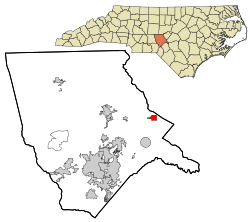 Location in Moore County and the state of North Carolina. | |
| Coordinates: 35°19′34″N 79°15′11″W / 35.32611°N 79.25306°WCoordinates: 35°19′34″N 79°15′11″W / 35.32611°N 79.25306°W | |
| Country | United States |
| State | North Carolina |
| County | Moore |
| Area | |
| • Total | 1.1 sq mi (2.7 km2) |
| • Land | 1.1 sq mi (2.7 km2) |
| • Water | 0.0 sq mi (0.0 km2) |
| Elevation | 358 ft (109 m) |
| Population (2010) | |
| • Total | 285 |
| • Density | 143.8/sq mi (55.5/km2) |
| Time zone | Eastern (EST) (UTC-5) |
| • Summer (DST) | EDT (UTC-4) |
| FIPS code | 37-09800[1] |
| GNIS feature ID | 1019484[2] |
Cameron is a town in Moore County, North Carolina in the United States. The population was 285 at the 2010 census.
History
Cameron grew up around a plank road that was followed in later years by a railroad. The town was planned in 1875 and incorporated in 1876. Cameron was at the end of the Raleigh and Augusta Railroad. Its location made it an ideal place of entrepreneurs to establish businesses. They built turpentine distilleries, established mercantile and hotel businesses to serve the needs of the railroad's customers and built a thriving dewberry farming and consignment operation.
Geography
Cameron is located at 35°19′34″N 79°15′11″W / 35.32611°N 79.25306°W (35.326096, -79.253159).[3]
According to the United States Census Bureau, the town has a total area of 1.0 square mile (2.6 km2), all land.
Neighboring towns include Vass to the south and Carthage to the west.
Demographics
| Historical population | |||
|---|---|---|---|
| Census | Pop. | %± | |
| 1880 | 117 | — | |
| 1890 | 236 | 101.7% | |
| 1900 | 218 | −7.6% | |
| 1910 | 259 | 18.8% | |
| 1920 | 241 | −6.9% | |
| 1930 | 287 | 19.1% | |
| 1940 | 311 | 8.4% | |
| 1950 | 284 | −8.7% | |
| 1960 | 298 | 4.9% | |
| 1970 | 204 | −31.5% | |
| 1980 | 225 | 10.3% | |
| 1990 | 215 | −4.4% | |
| 2000 | 151 | −29.8% | |
| 2010 | 285 | 88.7% | |
| Est. 2015 | 295 | [4] | 3.5% |
As of the census[1] of 2000, there were 151 people, 66 households, and 41 families residing in the town. The population density was 143.8 people per square mile (55.5/km²). There were 78 housing units at an average density of 74.3 per square mile (28.7/km²). The racial makeup of the town was 64.90% White and 35.10% Black.
There were 66 households out of which 25.8% had children under the age of 18 living with them, 40.9% were married couples living together, 18.2% had a female householder with no husband present, and 36.4% were non-families. 31.8% of all households were made up of individuals and 16.7% had someone living alone who was 65 years of age or older. The average household size was 2.29 and the average family size was 2.88.
In the town the population was spread out with 17.9% under the age of 18, 9.9% from 18 to 24, 30.5% from 25 to 44, 20.5% from 45 to 64, and 21.2% who were 65 years of age or older. The median age was 42 years. For every 100 females there were 75.6 males. For every 100 females age 18 and over, there were 82.4 males.
The median income for a household in the town was $32,500, and the median income for a family was $41,964. Males had a median income of $32,917 versus $22,500 for females. The per capita income for the town was $15,337. There were 17.9% of families and 21.3% of the population living below the poverty line, including 13.5% of under eighteens and 45.8% of those over 64.
Notable people
- Jeff Hardy, professional wrestler
- Matt Hardy, professional wrestler
- Shannon Moore, professional wrestler
- Trevor Lee (wrestler), professional wrestler
- Gregory Helms,professional wrestler
References
- 1 2 "American FactFinder". United States Census Bureau. Archived from the original on 2013-09-11. Retrieved 2008-01-31.
- ↑ "US Board on Geographic Names". United States Geological Survey. 2007-10-25. Retrieved 2008-01-31.
- ↑ "US Gazetteer files: 2010, 2000, and 1990". United States Census Bureau. 2011-02-12. Retrieved 2011-04-23.
- ↑ "Annual Estimates of the Resident Population for Incorporated Places: April 1, 2010 to July 1, 2015". Retrieved July 2, 2016.
- ↑ "Census of Population and Housing". Census.gov. Archived from the original on May 11, 2015. Retrieved June 4, 2015.
External links
- Historical information at the Cameron Antique Dealers Association website.
- Moore County Chamber of Commerce
Municipalities and communities of Moore County, North Carolina, United States | ||
|---|---|---|
| City |  | |
| Towns | ||
| Villages | ||
| CDP | ||
| Unincorporated communities | ||