Cameron, Louisiana
| Cameron, Louisiana | |
| Census-designated place | |
| Country | United States |
|---|---|
| State | Louisiana |
| Parish | Cameron |
| Elevation | 3 ft (0.9 m) |
| Coordinates | 29°47′17″N 93°18′42″W / 29.78806°N 93.31167°WCoordinates: 29°47′17″N 93°18′42″W / 29.78806°N 93.31167°W |
| Area | 12.6 sq mi (32.6 km2) |
| - land | 11.4 sq mi (29.5 km2) |
| - water | 1.2 sq mi (3.1 km2) |
| Population | 406 (2010) |
| Density | 35.5/sq mi (13.7/km2) |
| Timezone | CST (UTC-6) |
| - summer (DST) | CDT (UTC-5) |
| Zip code | 70631 |
| Area code | 337 |
| FIPS Code | 22023 |
 Location of Cameron in Louisiana
| |
 Location of Louisiana in the United States
| |
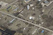
Cameron is a census-designated place (CDP) in and the parish seat of Cameron Parish, Louisiana, United States.[1] It is part of the Lake Charles Metropolitan Statistical Area. After sustaining extreme damage from Hurricane Rita in 2005 and Hurricane Ike in 2008, the 2010 Census showed Cameron having a population of just 406, a 79% drop in population between the years 2000 and 2010.[2]
History
In 1957, Cameron was nearly destroyed by Hurricane Audrey. A storm surge of 12 feet (3.7 m) and 150 miles per hour (240 km/h) winds caused the death of more than 300 residents of the town.[3]
Nearly fifty years later, in late September 2005, Hurricane Rita hit the town. This time, however, virtually everyone evacuated, and only one man was reported killed in the town. He is said to have been sick and decided to stay in town for the storm. His body was found in Lake Charles, 52 miles inland.[4]
On September 14, 2008, Hurricane Ike again leveled Cameron with a 22-foot (6.7 m) storm surge just as the town was recovering from Rita in 2005. Ike destroyed over 90 percent of the homes in the parish seat and caused catastrophic flooding in every part of the parish. Damage due to storm surge and winds was far worse than what was seen with Hurricane Rita.[5] A 2010 report on the damage sustained from the effects of Rita and Ike stated that few people returned to the town after the hurricanes, due to stricter building codes and high insurance costs that increased the cost of living dramatically. None of the stores have been rebuilt; only a gas station, bank, post office, and a restaurant remain (the latter two of which are still housed in trailers). Most of the residents still live in mobile homes. The First Baptist Church in the community was rebuilt in 2010.[6]
Culture
Cameron is on the Creole Nature Trail, a National Scenic Byway.
Cameron is home to the Louisiana Fur and Wildlife Festival held in January.
Geography
Cameron is located in south-central Cameron Parish at 29°47′17″N 93°18′42″W / 29.78806°N 93.31167°W (29.788055, -93.311764),[7] along the Gulf of Mexico at an elevation of 4 feet (1.2 m) above sea level. State highways 27 and 82 pass through the community as Marshall Street, crossing the Calcasieu Ship Channel just west of town. Highway 82 leads east 93 miles (150 km) to Abbeville and west 48 miles (77 km) to Port Arthur, Texas. Highway 27 leads west then north 48 miles (77 km) to Sulphur. Lake Charles is 52 miles (84 km) to the north.
According to the United States Census Bureau, the CDP has a total area of 12.6 square miles (32.6 km2), of which 11.4 square miles (29.6 km2) is land and 1.2 square miles (3.0 km2), or 9.31%, is water.[8]
Climate
| Climate data for Cameron, Louisiana | |||||||||||||
|---|---|---|---|---|---|---|---|---|---|---|---|---|---|
| Month | Jan | Feb | Mar | Apr | May | Jun | Jul | Aug | Sep | Oct | Nov | Dec | Year |
| Record high °F (°C) | 84 (29) |
80 (27) |
88 (31) |
93 (34) |
96 (36) |
98 (37) |
100 (38) |
103 (39) |
106 (41) |
98 (37) |
88 (31) |
81 (27) |
106 (41) |
| Average high °F (°C) | 59 (15) |
63 (17) |
70 (21) |
76 (24) |
82 (28) |
88 (31) |
90 (32) |
90 (32) |
87 (31) |
79 (26) |
70 (21) |
62 (17) |
76 (24) |
| Average low °F (°C) | 43 (6) |
46 (8) |
54 (12) |
61 (16) |
69 (21) |
74 (23) |
76 (24) |
75 (24) |
72 (22) |
62 (17) |
53 (12) |
45 (7) |
61 (16) |
| Record low °F (°C) | 13 (−11) |
11 (−12) |
25 (−4) |
35 (2) |
44 (7) |
54 (12) |
62 (17) |
59 (15) |
45 (7) |
29 (−2) |
20 (−7) |
12 (−11) |
11 (−12) |
| Average precipitation inches (mm) | 5.70 (144.8) |
3.46 (87.9) |
3.78 (96) |
4.01 (101.9) |
4.92 (125) |
6.63 (168.4) |
6.62 (168.1) |
5.47 (138.9) |
5.53 (140.5) |
4.37 (111) |
4.72 (119.9) |
5.37 (136.4) |
60.58 (1,538.8) |
| Average snowfall inches (cm) | 0.20 (0.51) |
0 (0) |
0 (0) |
0 (0) |
0 (0) |
0 (0) |
0 (0) |
0 (0) |
0 (0) |
0 (0) |
0 (0) |
0 (0) |
0.20 (0.51) |
| Source: http://www.intellicast.com/Local/History.aspx?location=USLA0070 | |||||||||||||


Demographics
As of the census[9] of 2000, there were 1,965 people, 695 households, and 510 families residing in the CDP. The population density was 70.5 people per square mile (27.2/km²). There were 800 housing units at an average density of 28.7 per square mile (11.1/km²). The racial makeup of the CDP was 82.49% White, 11.86% African American, 0.56% Native American, 0.31% Asian, 0.05% Pacific Islander, 3.36% from other races, and 1.37% from two or more races. Hispanic or Latino of any race were 5.55% of the population.
There were 695 households out of which 37.8% had children under the age of 18 living with them, 52.5% were married couples living together, 14.5% had a female householder with no husband present, and 26.6% were non-families. 21.2% of all households were made up of individuals and 6.3% had someone living alone who was 65 years of age or older. The average household size was 2.77 and the average family size was 3.17.
In the CDP the population was spread out with 27.5% under the age of 18, 10.8% from 18 to 24, 31.1% from 25 to 44, 21.5% from 45 to 64, and 9.1% who were 65 years of age or older. The median age was 34 years. For every 100 females there were 102.8 males. For every 100 females age 18 and over, there were 104.2 males.
The median income for a household in the CDP was $30,370, and the median income for a family was $33,661. Males had a median income of $24,762 versus $26,406 for females. The per capita income for the CDP was $13,499. About 17.0% of families and 19.4% of the population were below the poverty line, including 18.1% of those under age 18 and 13.6% of those age 65 or over.
Government and infrastructure
The United States Postal Service Cameron Post Office is located at 144 Adam Roux Street in the CDP.[10]
Education
The Cameron Parish School Board serves the town. South Cameron High School, a consolidated primary and secondary school, serves the community.
Prior to Hurricane Rita's impact in September 2005, South Cameron High School served area high schoolers while Cameron Elementary School, within Cameron, served grades pre-kindergarten through 7.[11] In September 2005 Hurricane Rita swept through Cameron Parish, damaging South Cameron Elementary, Cameron Elementary, and South Cameron High. The town's students shared Grand Lake High School's campus with Grand Lake for almost an entire year. In the fall of 2006 the three schools consolidated with all students going to the South Cameron High School campus.[12][13][14]
Two years later, in September 2008, Hurricane Ike came ashore and brought a 22-foot (6.7 m) storm surge, which was far worse than Rita's 10-foot (3.0 m) surge.[15] All of the coastline in the area was flooded heavily, with surge and floodwaters reaching 60 miles (97 km) inland, as far north as Lake Charles.[16][17] In Cameron Parish the communities of Holly Beach, Hackberry, Creole, Grand Chenier, and Cameron itself were essentially destroyed.[5] Hundreds of people had to be rescued from atop rooftops, including 363 people who were rescued by Louisiana Department of Wildlife and Fisheries Search and Rescue teams in conjunction with the Louisiana National Guard and the U.S. Coast Guard.[5][18] Ike caused varying degrees of damage to every school and library in Cameron Parish and surrounding parishes. Most were heavily flooded by storm surge and moderately damaged by winds, and as a result all schools were closed and a slow recovery process began.[19]
The Cameron Parish Public Library operates the main Cameron Parish Library at 469 Marshall Street in the Cameron CDP.[20]
References
- ↑ "Find a County". National Association of Counties. Archived from the original on 2011-05-31. Retrieved 2011-06-07.
- ↑ "Archived copy". Archived from the original on 2011-05-20. Retrieved 2011-10-01.
- ↑ Bob Henson. "Hurricane Audrey (August 19, 1998 Broadcast)". The Weather Notebook. Retrieved September 28, 2005.
- ↑ "Rita ravages region near state line". CNN. 2005-09-26.
- 1 2 3 Associated Press (2008-09-14). "Most of Louisiana's Coast Still Flooded by Ike". KALB-TV. Retrieved 2008-09-15.
- ↑ 5 years after Rita hit, some left out of recovery Associated Press. Kunzelman, Michael. September 23, 2010.
- ↑ "US Gazetteer files: 2010, 2000, and 1990". United States Census Bureau. 2011-02-12. Retrieved 2011-04-23.
- ↑ "Geographic Identifiers: 2010 Demographic Profile Data (G001): Cameron CDP, Louisiana". U.S. Census Bureau, American Factfinder. Retrieved August 18, 2014.
- ↑ "American FactFinder". United States Census Bureau. Archived from the original on 2013-09-11. Retrieved 2008-01-31.
- ↑ "Post Office Location - CAMERON." United States Postal Service. Retrieved on December 6, 2008.
- ↑ "Faculty and Staff" as of June 28, 2004. Cameron Elementary School.
- ↑ Dixon, Pam. "Rebuilding Cameron schools." KPLC-TV. September 12, 2006.
- ↑ Dixon, Pam. "Cameron students return to campus after hurricane." KPLC-TV. August 20, 2006.
- ↑ Dixon, Pam. "What's ahead for Cameron schools?." KPLC-TV. May 19, 2006.
- ↑ Margaret Saizan. "A Visual Story of Hurricane Rita". Archived from the original on August 14, 2007. Retrieved June 26, 2007.
- ↑ Mega Surge Archived October 16, 2008, at the Wayback Machine.
- ↑ Surge floodwaters Archived October 16, 2008, at the Wayback Machine.
- ↑ Search and Rescue Operations Coordinated by LDWF Transport 363 Residents to Safety During Hurricane Ike's Pass Through State, September 16, 2008 Emergency.Louisiana.gov
- ↑ "Ike Damage to Schools". Libraryjournal.com. 2013-11-15. Retrieved 2013-11-24.
- ↑ "Louisiana Library Directory." State Library of Louisiana. Accessed September 22, 2008.
External links
| Wikimedia Commons has media related to Cameron, Louisiana. |
- "Summary of Cameron". National Scenic Byways. Retrieved September 28, 2005.
- "Photo of Cameron after Hurricane Rita". Washington Post. Retrieved September 28, 2005.
- Louisiana Fur and Wildlife Festival
Municipalities and communities of Cameron Parish, Louisiana, United States | ||
|---|---|---|
| CDPs | 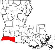 | |
| Unincorporated communities | ||