Camellia, New South Wales
| Camellia Sydney, New South Wales | |||||||||||||
|---|---|---|---|---|---|---|---|---|---|---|---|---|---|
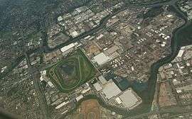 Aerial view of Camellia | |||||||||||||
| Coordinates | 33°49′15″S 151°01′33″E / 33.82078°S 151.02585°ECoordinates: 33°49′15″S 151°01′33″E / 33.82078°S 151.02585°E | ||||||||||||
| Postcode(s) | 2142 | ||||||||||||
| Location | 23 km (14 mi) west of Sydney CBD | ||||||||||||
| LGA(s) | City of Parramatta | ||||||||||||
| State electorate(s) | Parramatta | ||||||||||||
| Federal Division(s) | Parramatta | ||||||||||||
| |||||||||||||
Camellia is an post industrial suburb of Sydney, in the state of New South Wales, Australia. It began brownfields remediation in late 2015, and is ear-marked as a major centre for high density living.[1]
Camellia is located 23 kilometres (14 mi) west of the Sydney central business district in the local government area of the City of Parramatta. The suburb is bounded by the Parramatta River to the north, Clay Cliff Creek to the west, Duck River to the east, and Grand Avenue. Major roads dissecting the suburb are Grand Avenue (east-west) and James Ruse Drive (north-south).
History
The first inhabitants and visitors
The Burramattagal clan were the indigenous people who originally inhabited this area, relying on the fish, shellfish, bird life reptiles and marsupials that were once abundant in the waterways and forests adjoining the Parramatta River and the freshwaters of Clay Cliff Creek.
On 22 April 1788 Governor Arthur Phillip and his party of officers and marines journeyed inland by boat from Sydney Cove to find better farmlands for the new settlement. They landed at the head of a navigable river near what is now Clyde, which he called Duck River due to the abundance of ducks in the area.[2] They left their boats to explore the area but could not penetrate the thick bush. The party moved to the banks of Clay Cliff Creek, where they decided to camp because of its fresh water.[3]
In his Journal, surgeon John White recorded:
...we fell in with an hitherto unperceived branch of Port Jackson harbour, along the bank of which the grass was tolerably rich and succulent, and in height nearly up to the middle, interspersed with a plant much resembling the indigo. We followed this branch westward for a few miles, until we came to a small fresh-water stream that emptied itself into it. Here we took up our quarters for the night, as our halts were always regulated by fresh water, an essential point by no means to be dispensed with, and not very abundant or frequently to be met with, in this country. We made a kettle of excellent soup out of a white cockatoo and two crows, which I had shot, as we came along. The land all around us was similar to that which we had passed.
Clay Cliff Creek was the common boundary of the land grants to wool pioneer John Macarthur, who by the early 1800s extended his land grants and his Elizabeth Farm holdings to gain the complete river frontage between the township of Parramatta and Duck River.[3]
The railway station that opened here in 1885 was originally called Subiaco, but it caused confusion because this was the name of the Benedictine school on the opposite side of Parramatta River. In 1901, the station name was changed to Camellia, after the Camellia Grove Nursery nearby that specialised in growing Camellias. This land was leased by Silas Sheather since 1852 on what was originally part of the 850 acres (3.4 km2) of Elizabeth Farm.[4]
Commercial area
Camellia is predominantly an industrial and commercial area. An office block close to the railway station contains an Aldi supermarket. This is the former site of the James Hardie asbestos plant where Bernie Banton worked.
Transport
Camellia railway station is on the Carlingford Line of the Sydney Trains network. Grand Avenue is the main road in Camellia.
A conversion of the Carlingford to Camellia section of the Carlingford railway line to light rail was announced in 2015 as part of the Parramatta Light Rail project. A second line, from Strathfield, will join the Carlingford line at Camellia before both lines proceed to Westmead.[5]
Gallery
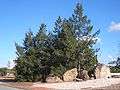 Grand Avenue, decorative rocks.
 Industry in Camellia.
References
- ↑ http://www.planning.nsw.gov.au/camellia
- ↑ "Plants - Duck River". Duck River Sydney Biodiversity. Retrieved 25 October 2012.
- 1 2 McClymont, John (June 2009). "Camellia". Sydney Journal. 2 (1): 82–91. ISSN 1835-0151. Retrieved 9 July 2013.
- ↑ The Book of Sydney Suburbs, Compiled by Frances Pollen, Angus & Robertson Publishers, 1990, Published in Australia ISBN 0-207-14495-8
- ↑ "Parramatta Light Rail - How the preferred network was chosen". Transport for NSW. Retrieved 8 December 2015.
| Wikimedia Commons has media related to Camellia, New South Wales. |