Camel's Hump
| Camel's Hump | |
|---|---|
 Camel's Hump, July 2012 | |
| Highest point | |
| Elevation | 4,083 ft (1,244 m) NAVD 88[1] |
| Prominence | 1,860 ft (570 m) [2] |
| Listing |
New England 4,000-footers New England Fifty Finest #46 |
| Coordinates | 44°19′10.37″N 72°53′10.78″W / 44.3195472°N 72.8863278°WCoordinates: 44°19′10.37″N 72°53′10.78″W / 44.3195472°N 72.8863278°W[1] |
| Geography | |
| Location | Huntington / Duxbury, Vermont, U.S. |
| Parent range | Green Mountains |
| Geology | |
| Age of rock | 550 million years[3] |
| Climbing | |
| Easiest route | Hiking trail |
| Designated | 1968 |
| Camel's Hump State Park | |
|---|---|
| Type | State park |
| Location |
Camel's Hump Road Huntington, Vermont |
| Area | About 20,000 acres |
| Operated by | Vermont Department of Forests, Parks, and Recreation |
| Website | http://www.vtstateparks.com/htm/camelshump.htm |
Camel's Hump (alternatively Camels Hump) is Vermont's third-highest mountain and highest undeveloped peak. Because of its distinctive profile, it is perhaps the state's most recognized mountain, featured on the state quarter. It is part of the Green Mountain range. With its neighbor to the north, Mount Mansfield, it borders the notch that the Winooski River has carved through the ridgeline of the Green Mountains over eons. The hiking trails on Camel's Hump were among the first cut in the Long Trail system, and Camel's Hump remains a popular summit for through- and day-hiking. The mountain is part of Camel's Hump State Park.
Name
Since Europeans first saw the mountain, probably on Samuel de Champlain's 1609 trip down Lake Champlain to the west, the mountain has had a number of names related to its distinctive shape. De Champlain named the mountain "Le Lion Couchant", a heraldic image which roughly translates as "The Resting Lion". Ira Allen later referred to the mountain as "Camel's Rump" on a map from 1798. It was not until 1830 that the name "Camel's Hump" came into usage.[4] The Geographic Names Information System (GNIS) lists twelve variant names including Tah-wak-be-dee-ee-so wadso and Catamountain.[5] While place names are determined by local usage the U.S. Board on Geographic Names (BGN) serves as a central authority in the United States concerning place names. Since its inception in 1890 the BGN has discouraged the use of the genitive apostrophe.[6] This sometimes results in confusion. Local usage is often at odds with this policy and so the name of this mountain is alternatively spelled with and without an apostrophe.
Geology
Camel's Hump is more notable for its shape than its height. Isolated from neighboring peaks by the Winooski Valley and glacial action, the mountain's conical silhouette is distinctive, if misleading. It has two "humps", with the southernmost being the higher, and a steep drop to the south as a result of a quarrying action of the ice passing over it. While it looks somewhat volcanic from the east and west, the movement of glacial ice created its current form and the National Park Service names the peak as "an exceptional illustration of the complex anticlinal deformation which formed the Green Mountains".[7] The bedrock consists of phyllite, quartzite and schist.[8]
Botany
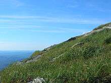
The summit of Camel's Hump is home to 10 acres (4 ha) of alpine tundra vegetation.[7] Plants found in this region include: Bigelow's sedge, alpine bilberry, mountain sandwort, crowberry, mountain cranberry, Labrador tea, Trillium undulatum.[3] A direct result of glacial formation, these alpine species were once widespread but as the lower elevations warmed, only the very peak of Camel's Hump remained hospitable to the fragile plants.[3]
Camel's Hump also supports a significant population of red spruce trees which have been under decline.[9] The Forest Decline Project at the University of Vermont published a study in 1991 citing acid rain as a culprit of the reduced seed production and germination.[10]

History
The Abnaki name for the mountain was "ta wak be dee esso wadso," or "tahwahbodeay wadso" (wadso meaning mountain), which has been variously translated as "resting place", "sit-down place", and "prudently, we make a campfire in a circle near water (and rest) at this mountain."[11]
In 1905, publisher and philanthropist Joseph Battell donated 1,200 acres (4.9 km2) of virgin forest, including the summit of Camel's Hump, to the State of Vermont.[12] The bequest was intended to form a state park to be kept in a "primitive state" and in 1911 the state forester was given charge of the area who managed the land in accordance with Battell's wishes. Since then, Vermont has adopted new legislation to preserve its natural areas and in 1969 created a Forest Reserve enclosing the mountain. Camel's Hump State Park has grown since the original bequest and in 1991 totalled approximately 20,000 acres (81 km2).[4]
In October 1944, during World War II, a B-24J bomber on a training mission crashed into the side of the mountain near the summit. While most of the plane was salvaged and removed, portions of the wreckage (principally a wing section) still remain. The Alpine Trail passes by the site.[3]
Though protected, the Camel's Hump area is a favorite recreational venue for hikers. Trail work began on Camel's Hump at the formation of the Green Mountain Club (GMC) and by 1912, a trail had been constructed between the mountain and Sterling Pond.[13] This initial trail would later become a high point in the "footpath in the wilderness" known as the Long Trail. In the 1950s, the GMC constructed shelters along the trail and at the summit. The GMC now trains and pays a caretaker to reside near the summit during the summer and educate hikers to respect the fragile alpine ecosystem that exists on the mountain.
In 1999, an image of Camel's Hump was chosen as a prominent feature for the Vermont state quarter. While many other options were considered, including covered bridges and the snowflake photographs of Wilson Bentley, the seven-person panel ultimately decided on Camel's Hump stating that it was "perfect for the quarter." The panels findings explained the choice: "It's wild and natural, like the Vermont countryside. It's unique and asymmetrical, like the independent and quirky reputation Vermonters have."[14] Many notable Vermont institutions have adopted its memorable name, including the children's radio show "Camel's Hump Radio" hosted by Bill Harley on Vermont Public Radio.[15] The profile of Camel's Hump appears in the Vermont coat of arms on the Vermont flag.
Hiking Camel's Hump

"With the only undeveloped alpine area in the Green Mountain State and a skyline that sets it apart from everything else, Camel's Hump may be Vermont's finest peak," says Michael Lanza in his guidebook for New England hiking enthusiasts.[16] The views from the summit are panoramic, and on a clear day one can see the highest peaks of the following states: Mount Marcy in New York, Mount Washington in New Hampshire and Vermont's Mount Mansfield.[9]
Burrows ascends the west face from the end of Camel's Hump Road taken east from Huntington and is roughly 2.4 miles (3.9 km) from trailhead to summit. The Burrows Trail is also used in the winter as a snowshoe and ski route.
An alternative trailhead approximately 0.5 miles (0.8 km) downhill from the Burrows trailhead on Camel's Hump Road, the Forest City Trail heads farther south, passes some very picturesque streams and waterfalls (Brush Brook), and meets the Long Trail at Montclair Glen Lodge. From this location, the Long Trail climbs the south face, which is steep and mildly technical towards the summit. There is a short connector trail, connecting the bottom of Burrows Trail to the waterfall bridges at Forest City, for those choosing to use the Burrows Trail upon descent.
The Monroe Trail ascends the east face, which is an easy to moderate trail similar to the Burrows Trail, but slightly longer.
The Long Trail continues north from the summit, and there are numerous side trails around the summit itself that are good for exploration in the summer.
There is a clearing approximately 200 yards (180 m) north of the summit, where the Burrows and Monroe Trails intersect the Long Trail. The clearing is the last protected environment one faces when climbing the mountain from the north, and once above treeline winds and temperatures can be severe at times.
Gallery
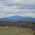 Western face of Camel's Hump Mountain from Charlotte, Vermont.
 Camel's Hump from Hinesburg Hollow Rd., Huntington, Vermont: Jul 2006
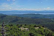 View east from old fire tower atop Poke-O-Moonshine Mountain in Chesterfield, NY: 2008
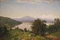 Painting of Camel's Hump by John Frederick Kensett, 1852, oil on canvas.
 Eastern face of Camel's Hump taken in 1968
.jpg) Postcard of eastern face of Camel's Hump
Postcard of eastern face of Camel's Hump.jpg) Postcard of western face of Camel's Hump
Postcard of western face of Camel's Hump
References
- 1 2 "Camels Hump 2 Reset". NGS data sheet. U.S. National Geodetic Survey. Retrieved 2008-11-24.
- ↑ "Camels Hump, Vermont". Peakbagger.com. Retrieved 2008-11-24.
- 1 2 3 4 Bazilchuk, Nancy. "Camel's Hump State Park". The Longstreet Highroad Guide to the Vermont Mountains. ISBN 1-56352-504-6. Retrieved 2008-04-16.
- 1 2 "Camel's Hump State Park". Retrieved July 1, 2007.
- ↑ "Camels Hump". Geographic Names Information System. United States Geological Survey. Retrieved April 4, 2010.
- ↑ "Domestic Names - Frequently Asked Questions". U.S. Board on Geographic Names. Retrieved April 4, 201. Check date values in:
|access-date=(help) - 1 2 "Camel's Hump: National Natural Landmark". National Park Service. Retrieved 2007-06-19.
- ↑ Thompson, Peter and Thelma (1991). "Bedrock Geology of the Camels Hump-Bolton Mountain Area, North-Central Vermont" (PDF). Retrieved 27 January 2016.
- 1 2 "Camel's Hump". Dartmouth Outing Guide. Dartmouth Outing Club. 2004. p. 173. Retrieved 2008-11-27.
- ↑ Klein, Richard M.; Perkins; Tricou; Oates; Cutler (Sep 1991). "Factors Affecting Red Spruce Regeneration in Delining Areas of Camel's Hump Mountain, Vermont". American Journal of Botany. 78 (9): 1191–1198. doi:10.2307/2444923. JSTOR 2444923.
- ↑ Huden, John C (1962). Indian Place Names of New England. Museum of the American Indian Heye Foundation. ISBN 0-934490-18-X.
- ↑ Ring, Wilson (October 7, 2001). "Vermont still has stands of old-growth forests". The Associated Press State & Local Wire.
- ↑ "History of the Long Trail". The Green Mountain Club. Retrieved June 19, 2007.
- ↑ "Camel's Hump picked for new Vt. quarter". The Boston Globe. Associated Press. June 11, 1999.
- ↑ "Camel's Hump". Vermont Public Radio. Retrieved June 19, 2007.
- ↑ Lanza, Michael (2004). Foghorn Outdoors' New England Hiking: The Complete Guide to More Than 380 Hikes. Avalon Travel Publishing. ISBN 1-56691-381-0.
- Johnson, Charles W. (1980). The Nature of Vermont: Introduction and Guide to a New England Environment. The University Press of New England. ISBN 0-87451-856-3.
- Meeks, Harold A. (1986). Vermont's Land and Resources. The New England Press. ISBN 0-933050-40-2.
- Morrissey, Charles T. (1984). Vermont A History. W.W.Norton and Co. ISBN 0-393-30223-7.
External links
| Wikimedia Commons has media related to Camel's Hump. |
- Camel's Hump State Park - official site
- "Camels Hump". Geographic Names Information System. United States Geological Survey. Retrieved 2008-11-27.
- "Hiking Camel's Hump, Vermont". Peakbagging the 4000 Footer Mountains of New England. Retrieved 2008-11-27.
- "Camel's Hump Mountain Photo Group". Flickr. May 2014. Retrieved 2014-05-24.
- "Camel's Hump hike and trip report". Peak Fever. June 2011. Retrieved 2011-07-14.