Calveley Hall
- For the house with a similar name in West Yorkshire see Calverley Old Hall
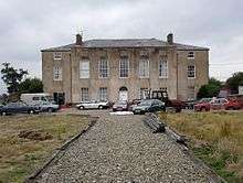
Calveley Hall is a country house to the west of the village of Milton Green, Cheshire, England. It was built in 1684 for Lady Mary Calveley.[1] After Lady Mary's death the estate passed by marriage to the Leghs of Lyme.[2] In 1818 it was remodelled for Thomas Legh, and further alterations have been carried out during the 20th century. The house is constructed in rendered brick with stone quoins. It stands on a stone plinth, has hipped roofs in Welsh slate, and three brick chimneys. The entrance front has three storeys, and is symmetrical with seven bays, the bays at the ends being slightly set back.[1] The architectural historian Nikolaus Pevsner describes it as being "absolutely plain".[3] Inside the house is a broad staircase with double twisted balusters, and newels carved with coats of arms, including those of Lady Mary. One of the rooms in the upper floor has an overmantel carved with the Calveley arms.[2] The hall is recorded in the National Heritage List for England as a designated Grade II* listed building.[1] The gate piers and front garden walls are listed at Grade II.[4]
In 2006 the building was in a poor state of repair and as of 2015 the building is on the Buildings at Risk Register.[5]
See also
References
- 1 2 3 Historic England, "Calveley Hall (1278640)", National Heritage List for England, retrieved 2 April 2012
- 1 2 de Figueiredo, Peter; Treuherz, Julian (1988), Cheshire Country Houses, Chichester: Phillimore, pp. 222–223, ISBN 0-85033-655-4
- ↑ Pevsner, Nikolaus; Hubbard, Edward (2003) [1971], Cheshire, The Buildings of England, New Haven and London: Yale University Press, p. 233, ISBN 0-300-09588-0
- ↑ Historic England, "Gate piers and front garden walls to Calveley Hall (1230244)", National Heritage List for England, retrieved 2 April 2012
- ↑ "Calveley Old Hall, Chapel Lane, Handley - Cheshire West and Chester (UA)". Buildings at Risk Register. Historic England. Retrieved 18 September 2015.
Coordinates: 53°07′18″N 2°49′00″W / 53.12158°N 2.81673°W