Calmont (hill)
| Calmont | |
|---|---|
|
| |
| Highest point | |
| Elevation | 380.6 m above sea level (NHN) (1,249 ft) [1] |
| Coordinates | 50°06′33″N 7°07′25″E / 50.109056°N 7.123556°ECoordinates: 50°06′33″N 7°07′25″E / 50.109056°N 7.123556°E |
| Geography | |
 Calmont | |
| State/Province | DE-RP |
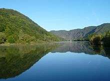
 Ruins of Stuben Abbey, Moselle and Calmont | |


The Calmont, also called the Calmond, between Bremm and Ediger-Eller in the county of Cochem-Zell in the German state of Rhineland-Palatinate, is a steep hill on the heights above the Moselle river to a height of 380.6 m above sea level (NHN).[1] It lies within the Moselle wine region and is home to the vineyards of Bremmer Calmont and Ellerer Calmont which, with gradients of up to over 65º, are among the steepest vineyards in the world.[2]
Name
The name Calmont may be derived either:
- from the Latin calidus = "warm" and mons = "hill", i.e. "warm hill",
- from the Celtic kal = "hard", i.e. "rock hill"
Geography
Location
The Calmont rises between Bremm to the south-southwest and Ediger-Eller further downstream to the southeast, both of which lie on the left bank of the river. Its summit is on the municipal boundary; its southern hillside belongs to Bremm, its northern and eastern slopes to Ediger-Eller. The |Ellerbach stream flows to the north and east around the ridge and empties into the Moselle southeast of the hill. To the southwest the countryside climbs up to the Schafstall (423 m).
Natural region allocation
The Calmont belongs within the natural region major unit group of Moselle Valley (Moseltal, no. 25), in the major unit of the Central Moselle Valley (Mittleres Moseltal, 250), in the sub-unit of Middle Moselle (Mittelmosel, 250.3) and the natural region of Cochemer Krampen (250.33). It terrain descends to the north into the Ellerbach valley, to the northwest and west and, ascending to the west-southwest to the Schafstall, into the natural region of Gevenicher Hochfläche (270.02), which is part of major unit group of the East Eifel (27), major unit of the Moselle Eifel (270) and sub-unit of the Eastern Moselle Eifel (Östliche Moseleifel, 270.0).
Height
The 380.6 m-high Calmont summit lies 293.1 metres above the Moselle, on which the lowest contour line on topographic maps is 87.5 m.[1] It is also an average of about 270 metres above Bremm. Around 215 metres east-northeast of the summit is a spot height of 378.4 m.[1]
Conservation
The Calmont lie within the protected area of Moselle Region from Schweich to Koblenz (Moselgebiet von Schweich bis Koblenz, CDDA No. 323051; established in 1979; 1187.48 km²), in the Special Area of Conservation of Hillsides and Side Valleys of the Lower Moselle (Moselhänge und Nebentäler der unteren Mosel, FFH No. 5809-301; 162.73 km²) and in the bird reserve of Woods between Wittlich and Cochem (Wälder zwischen Wittlich und Cochem, VSG No. 5908-401; 235.52 km²). Neither the SAC nor the bird reserve quite reach the banks of the Moselle river.[3]
Gallo-Roman Ambulatory Temple
On the summit of the Calmont there was a Roman hill shrine from the 2nd to around the 4th century AD. In 2005 the first archaeological excavations took place; they continued in 2008. In connexion with the excavations this Gallo-Roman ambulatory temple was reconstructed[4] and opened on 16 May 2009[5]
Viniculture
In the late 20th century only part of the original vineyards were still being cultivated. The largest contiguous area is the Bremmer Calmont with 33 ha.[6] On its steep slate hillsides grows a particularly good Riesling, however the vintners still have to use manual labour and muscle power (→ steep vineyards). After winegrowing had declined for decades on the Calmont massif for economic reasons, since 2005 several vintners have been ready to restock their vineyards. They hope that the greater profile of the location will enable them to market their products better. A wine estate has meanwhile offered to rent vine stocks.
Monument and viewing plateau
665 metres (as the crown flies) west-southwest of the summit of the Calmont, near a spot height 372.5 m,[1] is the Monument to the Wartime Generation (Mahnmal der Kriegsgeneration), a 12-metre-high summit cross that was erected around 1970 and is visible from a long way off. Next to the hut there, which is opened from Easter to October as a Straußwirtschaft, is an "observation plateau" from where there are good views, especially of the great loop in the Moselle, 285 m below, along with the nearby ruins of Stuben Abbey with, downstream, the villages of Neef, Bremm and Ediger-Eller.
Transport and Hiking
Along the southern foot of the Calmont, running from west to east between the Moselle villages of Bremm and Ediger-Eller is the B 49 federal highway. East to southeast of the ridge is the 4,205-metre-long Kaiser Wilhelm Tunnel which runs from north-northeast to south-southwest and carries the Moselle railway from Cochem to the station of Ediger-Eller and then over a 281-metre-long bridge over the Moselle.
On the Calmont runs the Calmont Klettersteig,[7] which was laid out by the German Alpine Club and opened on 4 May 2002[7] and on which can discover more about the hills and their flora and fauna.[8]
Paragliding
Near the Monument to the Wartime Generation is a launch area for paragliders who can fly over the Moselle valley in suitable wind conditions. The Calmont massif is like a huge concave mirror in the Moselle valley and, with its southerly orientation and slate bedrock, offers ideal conditions for the creation of thermal upcurrents.
References
- 1 2 3 4 5 Map service of the Landscape Information System of the Rhineland-Palatinate Nature Conservation Office (Naturschutzverwaltung Rheinland-Pfalz)
- ↑ Landentwicklung und Ländliche Bodenordnung, Ministerium für Umwelt, Landwirtschaft, Ernährung, Weinbau und Forsten des Landes Rheinland-Pfalz, Nachrichtenblatt, Heft 53/2012, S. 12, auf rlp.de (PDF; 10,4 MB)
- ↑ Map services of the Federal Agency for Nature Conservation
- ↑ Der Gallo-römische Umgangstempel auf dem Calmont, Förderverein Calmont-Region e. V., abgerufen am 4. Januar 2014, auf calmont-region.de
- ↑ Einweihung des gallorömischen Höhenheiligtums auf dem Calmont in: Das gallorömische Bergheiligtum auf dem Calmont → Einweihung des Bergheiligtums am 16. Mai 2009, abgerufen am 4. Januar 2014, auf calmont-klettersteig.com
- ↑ Karte der Weinlage Bremmer Calmont, auf weinlagen-info.de
- 1 2 Der Bremmer Calmont: Der Calmont-Klettersteig und Die Eröffnungsfeier am 4. Mai 2002, abgerufen am 4. Januar 2014, auf calmont-klettersteig.com
- ↑ Botanische Exkursion an die Mosel 13.08.2009–16.08.2009, abgerufen am 1. September 2015, auf botanik-bochum.de
External links
| Wikimedia Commons has media related to Calmont. |
- Information about the Calmont, at calmont.info
- Der Bremmer Calmont, at bremmer-calmont.de