California Bays and Estuaries Policy
The Water Quality Control Policy for the Enclosed Bays and Estuaries of California is published by the California State Water Resources Control Board as guidelines to prevent water quality degradation. The policy is revised as needed.[1]
Geography
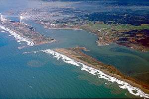
The Pacific coast of California has few natural harbors in comparison to similar lengths of the Atlantic coast of the United States.[2] Humboldt Bay, Bodega Harbor, Tomales Bay, Drakes Estero, San Francisco Bay, Morro Bay, Los Angeles - Long Beach Harbor, Upper Newport Bay, Newport Back Bay, Mission Bay, and San Diego Bay are identified by the policy. The policy also applies to smaller areas of ocean water within headlands or harbor works when the distance between those features is less than 75 percent of the greatest dimension of the enclosed portion.[1]
Mixing zones for fresh and ocean waters at the mouths of the Smith River, Klamath River, Mad River, Eel River, Noyo River, Russian River, and Sacramento–San Joaquin River Delta are identified as estuaries. The policy also applies to coastal lagoons and mouths of streams temporarily separated from the ocean by sandbars.[1]
The sheltering features making harbors favorable for ocean transportation cargo transfer[3] limit mixing and dilution through surf action and ocean currents.[4]
History
Harbors were important foci of early European American settlement of California; and cities have developed adjacent to the larger ones.[5] Unique aquatic ecosystems of limited geographical extent[6] have been impacted by waste disposal practices.[7] The Bays and Estuaries Policy adopted on 16 May 1974 concluded discharges of municipal wastewater and industrial process water should only be allowed when such discharges enhance the quality of the bay or estuary. Exceptions were made for San Francisco Bay and for cooling water discharges at other locations.[1] The policy was revised 16 November 1995.[8]
References
- 1 2 3 4 State Water Resources Control Board Water Quality Control Policy for the Enclosed Bays and Estuaries of California (1974) State of California
- ↑ York, Dolores Illustrated Atlas of the World (2004) Reader's Digest ISBN 0-7621-0510-0 pp.24-29
- ↑ Abbett, Robert W. American Civil Engineering Practice (1956) John Wiley & Sons p.21-02
- ↑ Millero, Frank G. Chemical Oceanography 2nd edition (1996) CRC Press ISBN 0-8493-8423-0 pp.76-87
- ↑ Donley, Allan, Caro and Patton Atlas of California (1979) Pacific Book Center ISBN 0-9602544-0-4 pp.12&13
- ↑ Reid, George K. Ecology of Inland Waters and Estuaries (1961) Van Nostrand pp.69-80
- ↑ "National Estuaries Program". United States Environmental Protection Agency. Retrieved 2010-03-06.
- ↑ State Water Resources Control Board Water Quality Control Policy for the Enclosed Bays and Estuaries of California (1995) State of California