Caldes de Montbui
| Caldes de Montbui | ||
|---|---|---|
| Municipality | ||
 | ||
| ||
 Caldes de Montbui  Caldes de Montbui Location in Catalonia | ||
| Coordinates: 41°37′45″N 2°10′10″E / 41.62917°N 2.16944°ECoordinates: 41°37′45″N 2°10′10″E / 41.62917°N 2.16944°E | ||
| Country |
| |
| Community |
| |
| Province | Barcelona | |
| Comarca | Vallès Oriental | |
| Government | ||
| • Mayor | Jordi Solé Ferrando (2015)[1] | |
| Area[2] | ||
| • Total | 37.4 km2 (14.4 sq mi) | |
| Elevation | 203 m (666 ft) | |
| Population (2014)[1] | ||
| • Total | 17,156 | |
| • Density | 460/km2 (1,200/sq mi) | |
| Demonym(s) |
Montbuienc, montbuienca Calderí, calderina | |
| Website |
www | |

Caldes de Montbui (Catalan pronunciation: [ˈkaɫdəz ðə mumˈbuj]) is a town and municipality in the comarca of the Vallès Oriental in Catalonia, Spain. It is situated in the upper valley of the Caldes river, and the highest point of the municipality is the peak of el Farell at 816 m. Lies about 30 km from Barcelona and it part of its metropolitan area.

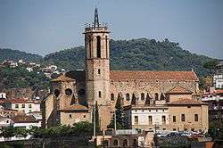
The hot springs have been exploited since Roman times, and the remnants of the Roman baths and other Roman buildings can still be seen. The source of la Font del Lleó ("Lion Springs") in the main square emerges at more than 70 °C (158 °F). The town conserves parts of its medieval fortifications and the Torre de la Presó (prison). The hermitage of la Mare de Déu del Remei dates from the sixteenth century, as does the church of Santa Maria with its baroque entrance. The roman church of Sant Sebastià de Montmajor, in the village of the same name at the extreme north-west of the municipality, is particularly well preserved.
The artist Manolo Hugué lived and worked in Caldes de Montbui, and his house has been converted into a museum displaying both his works and those of other artists. The town also has an archeological museum and the Delger museum of furniture, paintings and sculptures.
Continuing in this artistic tradition is the master landscape painter Ramon Vilanova, a native son of the city and lifetime resident.
Climate
| Climate data for Caldes de Montbui (elevation: 203 m (666 ft), data from 1941-1969) | |||||||||||||
|---|---|---|---|---|---|---|---|---|---|---|---|---|---|
| Month | Jan | Feb | Mar | Apr | May | Jun | Jul | Aug | Sep | Oct | Nov | Dec | Year |
| Average high °C (°F) | 13.3 (55.9) |
14.7 (58.5) |
17.7 (63.9) |
20.5 (68.9) |
23.7 (74.7) |
27.7 (81.9) |
30.9 (87.6) |
29.9 (85.8) |
27.4 (81.3) |
23.0 (73.4) |
17.6 (63.7) |
13.6 (56.5) |
21.7 (71.1) |
| Daily mean °C (°F) | 6.7 (44.1) |
7.8 (46) |
10.6 (51.1) |
13.1 (55.6) |
16.3 (61.3) |
20.2 (68.4) |
23.3 (73.9) |
23.0 (73.4) |
20.6 (69.1) |
16.2 (61.2) |
11.0 (51.8) |
7.5 (45.5) |
14.7 (58.5) |
| Average low °C (°F) | 0.0 (32) |
0.9 (33.6) |
3.6 (38.5) |
5.7 (42.3) |
8.9 (48) |
12.8 (55) |
15.7 (60.3) |
16.2 (61.2) |
13.8 (56.8) |
9.5 (49.1) |
4.4 (39.9) |
1.5 (34.7) |
7.8 (46) |
| Source: Sistema de Clasificación Bioclimática Mundial[3] | |||||||||||||
Demography
| 1900 | 1930 | 1950 | 1970 | 1986 | 2001 |
|---|---|---|---|---|---|
| 3474 | 4777 | 4729 | 8161 | 10,407 | 15,536 |
Note
- ^ Caldes de Montbui became part of the Vallès Oriental in the comarcal revision of 1990: previously it formed part of the Vallès Occidental.
References
- 1 2 "Ajuntament de Caldes de Montbui". Generalitat of Catalonia. Retrieved 2015-11-13.
- ↑ "El municipi en xifres: Caldes de Montbui". Statistical Institute of Catalonia. Retrieved 2015-11-23.
- ↑ "ESP BARCELONA - CALDES DE MONTBUI".
- Panareda Clopés, Josep Maria; Rios Calvet, Jaume; Rabella Vives, Josep Maria (1989). Guia de Catalunya, Barcelona:Caixa de Catalunya. ISBN 84-87135-01-3 (Spanish). ISBN 84-87135-02-1 (Catalan).
External links
| Wikimedia Commons has media related to Caldes de Montbui. |
- Official website (Catalan)
- Statistical information about the municipality (Catalan Statistic Institute) (Catalan)
- Information - Generalitat de Catalunya (Catalan)
 |
Gallifa | Sant Feliu de Codines | Bigues i Riells | |
| Sant Llorenç Savall | |
Santa Eulàlia de Ronçana | ||
| ||||
| | ||||
| Sentmenat | Palau-solità i Plegamans | Lliçà d'Amunt |
.svg.png)