Cairn Formation
| Cairn Formation Stratigraphic range: Frasnian | |
|---|---|
 | |
| Type | Formation |
| Unit of | Fairholme Group |
| Underlies | Southesk Formation |
| Overlies | Flume Formation |
| Thickness | Up to 180 metres (590 ft) |
| Lithology | |
| Primary | Dolostone |
| Other | Limestone, chert |
| Location | |
| Coordinates | 52°38′N 116°58′W / 52.633°N 116.967°WCoordinates: 52°38′N 116°58′W / 52.633°N 116.967°W |
| Region |
|
| Country |
|
| Type section | |
| Named for | Cairn River, Alberta |
| Named by | D.J. McLaren, 1955[1] |
The Cairn Formation is a geologic formation of Late Devonian (Frasnian) age in the Western Canada Sedimentary Basin.[2] It was named for the Cairn River near its junction with the Southesk River in Jasper National Park by D.J. McLaren in 1955.[1]
The Cairn Formation is stratigraphically equivalent to the Leduc Formation, which is a major oil-producing formation in central Alberta. Like the Leduc Formation, it was deposited in reef environments and is highly fossiliferous.[3][4] Extensive outcrops of the Cairn Formation near Canmore, Alberta are a popular field trip destination for those wishing to learn about Devonian reefs. They are also popular with rock climbers who enjoy the challenges presented by its extremely irregular surfaces.
Lithology
The Cairn Formation was originally deposited as limestones and mudstones in intertidal to subtidal reef environments, and was extensively dolomitized during later diagenesis. It now consists primarily of buff to dark grey, very fine to medium grained crystalline dolostone with good intercrystalline, biomoldic and vuggy porosity. Most of it is classified as floatstone, with stromatoporoids and other fossils supported in a dolostone matrix. [4][5] The Cairn also includes minor amounts of undolomitized limestone and chert.[6]
Paleontology
Bulbous stromatoporoids are particularly common in the Cairn Formation and were the main reef-building organism. There are also tabular stromatoporoids, Amphipora, horn corals, tabulate corals such as Thamnopora, brachiopods, crinoids, algae and foraminifera.[5][7] The organisms are commonly either in growth position or have only been moved short distances. Some stromatoporoids show evidence of bioerosion by boring sponges.[4]
Thickness and Distribution
The Cairn Formation typically ranges from 80 m (260 ft) to 180 m (590 ft) in thickness. It occurs in outcrop in the front and main ranges of the Canadian Rockies from Kakwa Lake in northeastern British Columbia to south of the Bow River in Alberta. It is also recognized in the subsurface in some areas.[6]
Relationship to Other Units
The Cairn Formation rests conformably on the Flume Formation, which is considered to be the lower member of the Cairn Formation in some areas, and it is overlain by the Peechee Member of the Southesk Formation. At reef margins the Cairn may interfinger with the Perdrix Formation which was deposited in deeper water, off-reef environments.
The Cairn Formation is equivalent to, but not contiguous with, the lower Leduc Formation which lies farther to the east in central Alberta. It is also equivalent to the Cooking Lake Formation in central Alberta, and to the lower Duperow Formation and possibly the upper Souris River Formation in the Williston Basin. Its relationship to units in the Crowsnest Pass area of southern Alberta has not been established.[6]
-

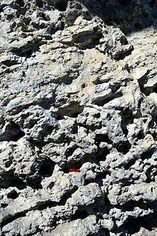
Cairn Formation outcrop at Grassi Lakes, near Canmore, Alberta, Canada.
-
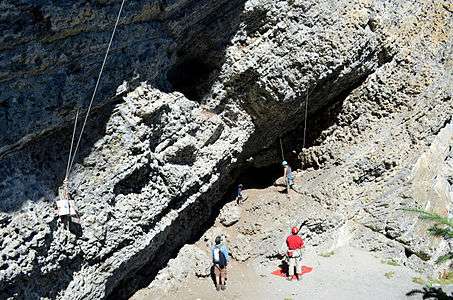
Rock climbing on the Cairn Formation at Grassi Lakes.
-
.jpg)
Cairn Formation stromatoporoid reef displayed in Calgary.
See also
References
- 1 2 McLaren, D.J. 1955. Devonian formations in the Alberta Rocky Mountains between the Bow and Athabasca Rivers. Geological Survey of Canada, Bulletin 35.
- ↑ Mossop, G.D. and Shetsen, I. (compilers), Canadian Society of Petroleum Geologists and Alberta Geological Survey (1994). "The Geological Atlas of the Western Canada Sedimentary Basin, Chapter 12: Devonian Woodbend-Winterburn strata of the Western Canada Sedimentary Basin". Retrieved 2016-06-20.
- ↑ Shields, M.J. and Geldsetzer, H.H.J. 1992. The MacKenzie margin, Southesk-Cairn carbonate complex: depositional history, stratal geometry and comparison with other Late Devonian platform-margins. Bulletin of Canadian Petroleum Geology, vol. 40, no. 3, p. 274-293.
- 1 2 3 Bloy, G.R., Hunter, I.G. and Leggett, S.R. 1984. Depositional environments of the Devonian Cairn Formation, Rocky Mountain front ranges, Canmore, Alberta. Carbonates in subsurface and outcrop: 1984 CSPG Core Conference, Canadian Society of Petroleum Geologists, p. 148.
- 1 2 Bloy, G.R., Leggett, S.R. and Hunter, I.G. 1989. The lower Fairholme reef complex (Cairn Formation), White Man Gap area, Canmore, Alberta. In: Reefs, Canada and adjacent areas. Canadian Society of Petroleum Geologists, Memoir 13, p. 399-402.
- 1 2 3 Glass, D.J. (editor) 1997. Lexicon of Canadian Stratigraphy, vol. 4, Western Canada including eastern British Columbia, Alberta, Saskatchewan and southern Manitoba. Canadian Society of Petroleum Geologists, Calgary, 1423 p. on CD-ROM. ISBN 0-920230-23-7.
- ↑ Noble, J.P.A. 1970. Biofacies analysis, Cairn Formation of the Miette reef complex (Upper Devonian), Jasper National Park, Alberta. Bulletin of Canadian Petroleum Geology, vol. 14, no. 4, p. 493-543.
- Various Contributors to the Paleobiology Database. "Fossilworks: Gateway to the Paleobiology Database". Retrieved 8 July 2014.