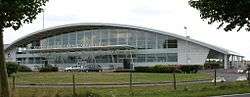
Caen – Carpiquet Airport
| Caen - Carpiquet Airport Aéroport de Caen - Carpiquet | |||||||||||||||
|---|---|---|---|---|---|---|---|---|---|---|---|---|---|---|---|
 | |||||||||||||||
| IATA: CFR – ICAO: LFRK | |||||||||||||||
| Summary | |||||||||||||||
| Airport type | Public | ||||||||||||||
| Operator | CCI de Caen | ||||||||||||||
| Serves | Caen, France | ||||||||||||||
| Location | Carpiquet, France | ||||||||||||||
| Elevation AMSL | 256 ft / 78 m | ||||||||||||||
| Coordinates | 49°10′24″N 000°27′00″W / 49.17333°N 0.45000°WCoordinates: 49°10′24″N 000°27′00″W / 49.17333°N 0.45000°W | ||||||||||||||
| Website | caen.aeroport.fr | ||||||||||||||
| Maps | |||||||||||||||
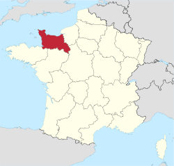 Lower Normandy region in France | |||||||||||||||
 LFRK Location of the airport in Lower Normandy | |||||||||||||||
| Runways | |||||||||||||||
| |||||||||||||||
|
Source: French AIP[1] | |||||||||||||||
Caen – Carpiquet Airport (French: Aéroport de Caen - Carpiquet) (IATA: CFR, ICAO: LFRK) is a civil airport located in Carpiquet and 6 km west of Caen,[1] both communes of the Calvados département in the Normandy (formerly Lower Normandy) region of France. Chalair Aviation has its head offices at the airport.[2]
Airlines and destinations
| Airlines | Destinations |
|---|---|
| Air France operated by HOP! | Lyon Seasonal: Nice |
| Chalair Aviation | Bordeaux[3] |
| Flybe operated by Stobart Air | London-Southend |
| Volotea | Seasonal: Ajaccio, Bastia,[4] Figari, Toulouse[5] |
References
- 1 2 LFRK – Caen Carpiquet. AIP from French Service d'information aéronautique, effective 8 December 2016.
- ↑ "Access." (image). Chalair Aviation. Retrieved on 12 February 2011. "Chalair Aviation Headquarters Aéroport de Caen-Carpiquet 14650 Carpiquet France."
- ↑ http://www.air-journal.fr/2016-02-25-chalair-reliera-caen-a-bordeaux-et-anvers-5158533.html
- ↑ http://www.routesonline.com/news/29/breaking-news/245049/update-as-of-22oct14-volotea-planned-new-routes-in-s15
- ↑ http://www.ouest-france.fr/normandie/caen-14000/deux-nouvelles-destinations-depuis-l-aeroport-de-caen-4574674?utm_medium=Social&utm_campaign=Echobox&utm_source=Twitter&utm_term=Autofeed#link_time=1477060038
External links
![]() Media related to Aéroport de Caen - Carpiquet at Wikimedia Commons
Media related to Aéroport de Caen - Carpiquet at Wikimedia Commons
- Aéroport de Caen - Carpiquet (official site) (French)
- Aéroport de Caen - Carpiquet (Union des Aéroports Français) (French)
- Airport information for LFRK at World Aero Data. Data current as of October 2006.
- Current weather for LFRK at NOAA/NWS
- Accident history for CFR at Aviation Safety Network
This article is issued from Wikipedia - version of the 10/24/2016. The text is available under the Creative Commons Attribution/Share Alike but additional terms may apply for the media files.