Cadolive
| Cadolive | ||
|---|---|---|
|
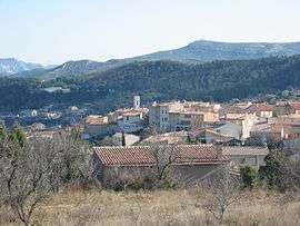
Cadolive from the west | ||
| ||
 Cadolive | ||
|
Location within Provence-A.-C.d'A. region  Cadolive | ||
| Coordinates: 43°23′46″N 5°32′41″E / 43.3961°N 5.5447°ECoordinates: 43°23′46″N 5°32′41″E / 43.3961°N 5.5447°E | ||
| Country | France | |
| Region | Provence-Alpes-Côte d'Azur | |
| Department | Bouches-du-Rhône | |
| Arrondissement | Marseille | |
| Canton | Roquevaire | |
| Intercommunality | Lou Païs d'Estello and Dou Merlançoun | |
| Government | ||
| • Mayor (2008–2014) | Serge Perottino | |
| Area1 | 4.18 km2 (1.61 sq mi) | |
| Population (2008)2 | 2,136 | |
| • Density | 510/km2 (1,300/sq mi) | |
| Time zone | CET (UTC+1) | |
| • Summer (DST) | CEST (UTC+2) | |
| INSEE/Postal code | 13020 / 13950 | |
| Dialling codes | 0491 | |
| Elevation |
328–645 m (1,076–2,116 ft) (avg. 384 m or 1,260 ft) | |
|
1 French Land Register data, which excludes lakes, ponds, glaciers > 1 km² (0.386 sq mi or 247 acres) and river estuaries. 2 Population without double counting: residents of multiple communes (e.g., students and military personnel) only counted once. | ||
.svg.png)
Cadolive is a commune situated east of Marseille at the eastern extremity of the Massif de l'Étoile between Peypin and Saint-Savournin in the department of Bouches-du-Rhône in the Provence-Alpes-Côte d'Azur region in southern France. Until 1900, it was considered a district of Saint-Savournin.
Population
| Historical population | ||
|---|---|---|
| Year | Pop. | ±% |
| 1901 | 19 | — |
| 1906 | 5 | −73.7% |
| 1911 | 5 | +0.0% |
| 1921 | 122 | +2340.0% |
| 1926 | 126 | +3.3% |
| 1931 | 230 | +82.5% |
| 1936 | 133 | −42.2% |
| 1946 | 74 | −44.4% |
| 1954 | 158 | +113.5% |
| 1962 | 138 | −12.7% |
| 1968 | 125 | −9.4% |
| 1975 | 112 | −10.4% |
| 1982 | 239 | +113.4% |
| 1990 | 626 | +161.9% |
| 1999 | 87 | −86.1% |
| 2008 | 136 | +56.3% |
See also
References
| Wikimedia Commons has media related to Cadolive. |
This article is issued from Wikipedia - version of the 2/11/2016. The text is available under the Creative Commons Attribution/Share Alike but additional terms may apply for the media files.