Caddo, Oklahoma
| Caddo, Oklahoma | |
|---|---|
| Town | |
| Motto: "...The antique town on a buffalo trail" | |
 Location of Caddo, Oklahoma | |
| Coordinates: 34°7′36″N 96°15′56″W / 34.12667°N 96.26556°WCoordinates: 34°7′36″N 96°15′56″W / 34.12667°N 96.26556°W | |
| Country | United States |
| State | Oklahoma |
| County | Bryan |
| Area | |
| • Total | 2.1 sq mi (5.4 km2) |
| • Land | 2.1 sq mi (5.4 km2) |
| • Water | 0.0 sq mi (0.0 km2) |
| Elevation | 728 ft (222 m) |
| Population (2010) | |
| • Total | 997 |
| • Density | 474.8/sq mi (184.6/km2) |
| Time zone | Central (CST) (UTC-6) |
| • Summer (DST) | CDT (UTC-5) |
| ZIP code | 74729 |
| Area code(s) | 580 |
| FIPS code | 40-10800[1] |
| GNIS feature ID | 1090794[2] |
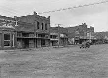
Caddo is a town in Bryan County, Oklahoma, United States. The population was 997 at the 2010 census, a 5.6 percent gain from 944 at the 2000 census.[3] The name is derived from a Caddo word, ka do hada’ cho, meaning "real chief" in English.[4] According to Encyclopedia of Oklahoma History and Culture, the town was named for the nearby Caddo Hills.[5]
History
The early inhabitants were Caddos and Choctaws, at least in the early 19th Century. A local legend says that the Caddis and the Choctaws had a fierce battle in 1840, about 2 miles (3.2 km) southeast of the site of present-day Caddo, The Choctaws won the battle, driving off the Caddos.[4]
After a patent for the land, located on a buffalo trail, was obtained in 1872, the first settlers lived in tents.
In 1872, the Missouri-Kansas-Texas Railroad (Katy) built a line through the Choctaw Nation and established a station at Caddo. A post office was opened December 18, 1872, and the railroad reached Denison, Texas by Christmas Day. In 1873, the town population was about four hundred people.[4] Caddo quickly became a shipping and trade center for the surrounding area. By 1890, Caddo had five cotton gins and a population of 2,170. Caddo incorporated as a city in 1898. It was then the most populous town in the region.[5]
When the St.Louis and San Francisco Railway (Frisco) planned to build an east-west line through the area, land prices jumped up. Frisco officials decided to build their line through Durant instead of Caddo. Durant then became the fastest-growing town, and became the county seat when Bryan County was formed at statehood. By 1930, Caddo's population had fallen to 933.[5][lower-alpha 1]
In 1943, Guy A. Crossett, the editor of The Caddo Herald newspaper described Caddo's decline. “Caddo was a thriving town when Durant was a switch; when Hugo was a prairie; when Madill was unborn; when Coalgate was un-thought-of; when Ardmore was only in Pennsylvania; when Idabel was yet to be; when Atoka was a small village. Yet all have outgrown us. The reason is plain. We did not elect a delegate to Bill Murray’s famous Constitutional Convention; and tried to live upon the glories of the past. Finding out too late that we could not run the mill with water that has passed. Yet Caddo’s part in the history of the state is honorable. That is secure. The future is another thing.”[6]
Geography
According to the United States Census Bureau, Caddo has a total area of 2.1 square miles (5.4 km2), all of it land.
Demographics
| Historical population | |||
|---|---|---|---|
| Census | Pop. | %± | |
| 1900 | 930 | — | |
| 1910 | 1,143 | 22.9% | |
| 1920 | 1,421 | 24.3% | |
| 1930 | 933 | −34.3% | |
| 1940 | 954 | 2.3% | |
| 1950 | 895 | −6.2% | |
| 1960 | 814 | −9.1% | |
| 1970 | 886 | 8.8% | |
| 1980 | 923 | 4.2% | |
| 1990 | 918 | −0.5% | |
| 2000 | 944 | 2.8% | |
| 2010 | 997 | 5.6% | |
| Est. 2015 | 1,048 | [7] | 5.1% |
As of the census[1] of 2000, there were 944 people, 387 households, and 255 families residing in the town. The population density was 449.0 people per square mile (173.6/km²). There were 443 housing units at an average density of 210.7 per square mile (81.4/km²). The racial makeup of the town was 77.97% White, 0.64% African American, 13.67% Native American, 0.21% Asian, 0.32% from other races, and 7.20% from two or more races. Hispanic or Latino of any race were 1.59% of the population.
There were 387 households out of which 29.2% had children under the age of 18 living with them, 51.9% were married couples living together, 9.8% had a female householder with no husband present, and 34.1% were non-families. 32.3% of all households were made up of individuals and 16.0% had someone living alone who was 65 years of age or older. The average household size was 2.34 and the average family size was 2.98.
In the town the population was spread out with 24.4% under the age of 18, 7.6% from 18 to 24, 24.2% from 25 to 44, 21.1% from 45 to 64, and 22.8% who were 65 years of age or older. The median age was 40 years. For every 100 females there were 91.5 males. For every 100 females age 18 and over, there were 83.5 males.
The median income for a household in the town was $26,250, and the median income for a family was $34,643. Males had a median income of $27,731 versus $18,846 for females. The per capita income for the town was $12,890. About 14.2% of families and 21.1% of the population were below the poverty line, including 30.8% of those under age 18 and 25.1% of those age 65 or over.
Culture and recreation
Caddo holds its Heritage Day Festival on the first Saturday in October every year.[4]
Notable people
- Cowboy Pink Williams (1892-1976), 7th lieutenant governor of Oklahoma
- James M. Flinchum (1916 - 2011), Born in Caddo, editor-in-chief of the former Wyoming State Tribune (since Wyoming Tribune Eagle) in Cheyenne, Wyoming
Notes
References
- 1 2 "American FactFinder". United States Census Bureau. Archived from the original on 2013-09-11. Retrieved 2008-01-31.
- ↑ "US Board on Geographic Names". United States Geological Survey. 2007-10-25. Retrieved 2008-01-31.
- ↑ CensusViewer:Caddo, Oklahoma Population
- 1 2 3 4 5 "Caddo, Oklahoma - History." Town Restoration Association of Caddo. Accessed November 28, 2016.
- 1 2 3 Brimage, Lucille. "Caddo," Encyclopedia of Oklahoma History and Culture, Oklahoma Historical Society, 2009. Accessed April 15, 2015.
- ↑ "20 First Facts". Caddo- My Home Town. Retrieved 2016-09-04.
- ↑ "Annual Estimates of the Resident Population for Incorporated Places: April 1, 2010 to July 1, 2015". Retrieved July 2, 2016.
- ↑ "Census of Population and Housing". Census.gov. Archived from the original on May 11, 2015. Retrieved June 4, 2015.
External links
Municipalities and communities of Bryan County, Oklahoma, United States | ||
|---|---|---|
| City | 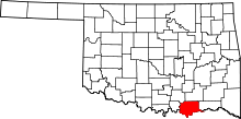 | |
| Towns | ||
| CDPs | ||
| Other unincorporated communities | ||
| Ghost towns | ||
| Achille | ||
|---|---|---|
| Bokchito | ||
| Caddo |
| |
| Colbert | ||
| Durant |
| |
| Kenefic | ||
| Nida | ||