Cadboro Bay
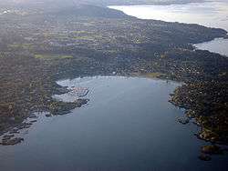
Cadboro Bay is a bay located on southern Vancouver Island in the Canadian province of British Columbia, located in the Municipality of Saanich and the Municipality of Oak Bay. It was Sungayka a village of the Songhees Nation existing for 8,000 years previous to the relocation of the people to the Inner Harbour in the mid 1800s: the land between Gyro Park and Telegraph Bay is included in a Douglas Treaty that is now before the courts. Cadboro Bay takes its name from the first European vessel to enter the bay, the Hudson's Bay Company schooner Cadboro.[1][2]
Before European settlers arrived, the bay was the site of a settlement called Sungayka, occupied by the Songhees people. Today, the bay gives its name to the neighbourhood situated between the bay itself and the University of Victoria, bounded by the Uplands district to the south, Ten Mile Point to the east and the Queenswood neighbourhood to the north. At the heart of this neighbourhood is its English style shopping street, Cadboro Bay Village.
A prominent resident of the neighbourhood in the first half of the 20th century was Frank V. Hobbs. His brother, Edwin, bought land in Cadboro Bay for a dairy farm, while Frank Hobbs engaged in business in Victoria and other parts of Vancouver Island. Upon the death of Edwin, Frank moved to Cadboro Bay, and became active in municipal politics and on the Victoria school board. He was influential in expanding the provision of high schools for greater Victoria. In recognition of this and other services he provided to the area, the local elementary school, opened in 1951, was named in his honour.[3]
The Royal Victoria Yacht Club is located on the Oak Bay side of the bay and is situated on a large archeological site of the Songhees Nation.
Cadboro-Gyro Park
Immediately adjacent to the beach itself is Cadboro-Gyro park. The park is popular with children in the neighbourhood as well as other parts of Victoria due to its large concrete climbing structures, in the form of an octopus, a large salmon, a tugboat and the local Cryptid, the sea monster Cadborosaurus.
The park was created on 4.37 acres of land bought from the Goward estate by the Gyro Club in 1953, which it donated to Saanich in 1954, and subsequently increased in 1961 by the expropriation of adjacent land by Saanich. The park is now 6.022 hectares (14.88 acres).[4] In the summer of 2014 the play area was improved, including the relocation of the octopus and salmon as well as a range of other improvements.[5]
References
- ↑ "Cadboro". Encyclopedia of British Columbia. Harbour Publishing. 2000.
- ↑ BCGNIS listing "Cadboro Bay" (bay)
- ↑ https://frankhobbs.sd61.bc.ca/our-school/history/
- ↑ Cadboro-Gyro Park Factsheet
- ↑ http://www.saanich.ca/parkrec/parks/projects/current/cadboro.html
Coordinates: 48°27′28″N 123°17′34″W / 48.457746°N 123.292859°W