Cabras Island Light
 1916 | |
 Isla Cabras Lighthouse | |
| Location | Ceiba, Puerto Rico |
|---|---|
| Coordinates | 18°12′42″N 65°36′0″W / 18.21167°N 65.60000°WCoordinates: 18°12′42″N 65°36′0″W / 18.21167°N 65.60000°W |
| Year first lit | 1908 |
| Automated | 1931 |
| Construction | Stone |
| Tower shape | Cylindrical attached to a square house |
| Markings / pattern | Natural "Turret" |
| Original lens | Sixth-order Fresnel 1908 |
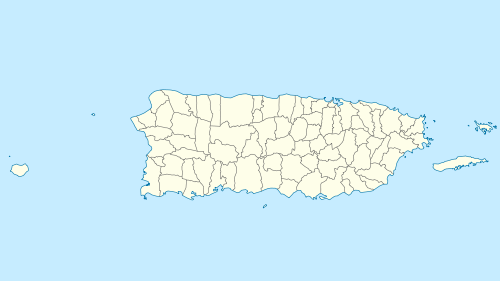
Isla Cabras Light, also known as Faro de Isla Cabras, was a lighthouse located on a rocky but flat islet with the same name, which sit just off the coast near Ceiba, Puerto Rico, toward the Vieques Passage.
Planning and construction
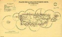
Fishing boats were not the only ones to cross the Vieques Passage, but also ocean-going ships. In fact, the expanse of water between Cabras Island and Vieques had become an important passway during the long duration of the Spanish colonial rule in Puerto Rico.[1] So, when in 1869 Madrid approved the lighthouse's construction on Cabras Island, few questioned its wisdom.[2] The initiative was not an isolated event, but part of an island-wide modernization project for "maritime illumination" (es: "Plan de Alumbrado Maritimo en la Isla de Puerto Rico"). Puerto Rico's coasts were coming into the light with the establishment of fourteen lighthouses of which the Cabras Island Light was the twelfth in line.[2]
At its roots, the project responded to unprecedented political pressure. Accusations against the Crown of abandonment and military upheavals of which the Grito de Lares ("Lares Cry" or "Lares Uprising") was only the best known, marked the year 1868. The following decade saw in Puerto Rico the formation of political parties, the abolition of slavery and environmental legislations like the act to protect the Yunque, among the oldest U.S. National Parks.[3] Though the increasingly liberal local government showed signs of life and interest in developing the island's infrastructure, the overstretched Spanish Empire, embroiled in wars for independence in Cuba and the Philippines,[4][5] neglected the construction of the Cabras Island Light.[6]
In 1898, during the Spanish–American War, the U.S. fleet maneuvered near the Cabras Island, learning first hand the value of its position between the bays of Bahía de Puerca and Ensenada Honda.[7] Soon after replacing the Puerto Rican autonomous government with a military regime, the U.S. picked up the light project as part of its naval expansion in the Caribbean area.[8] In 1904, the U.S. Coast Guard purchased the 20 acres (8 ha) of land for $200, and by May 13, 1908, the lighthouse was ready for service. The cost of the undertaking, including the entrance road and the pier, reached a total of $5654.55.[6][9][10]
Structure
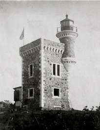
The lighthouse building was unique among the lighthouses in Puerto Rico in that it resembled the rectangular shape and design of the better-known light in the Morro, but with the castle's stone structure.[6] Differently from its San Juan relative, the building overseeing the Vieques Passage was a small two-story lightgray stone daymark structure with a red stripe and a clear white trim.[11] Its black lantern room sat on a small cylindrical tower on of its corners at the top of the building. It stood 78 feet off the ground, and projected a white light visible all around, showing higher intensity on range line for nine miles away (some even say 14).[12][13] Its original lens was a sixth-order Fresnel lens.[14]
Employment
A keeper managed the light and occupied the building's two rooms. As the islands of Culebra and Vieques became both military posts and tourists destinations, the lighthouse played a role in safeguarding the increasing number of trips across the passage. Traveler's accounts refer to its beauty and powerful light over the waters.[12][15] In 1937, as part of the changes that Gustaf Dalén affected in the gas and lighthouse technologies,[16] the authorities installed an automated acetylene torch. Six years later, the building was closed and boarded. In 1965 the light was replaced with a range light called "Vieques Southwest Channel Range Front Light".[17] The original structure was destroyed in 1966.
Setting
Cabras Island is located in the former Roosevelt Roads Naval Station. The small island separates the entrance of Puerca Bay, a small open-mouth bay and the Ensenada Honda harbor. The island is connected to the mainland by a causeway.
External links
- Historic Light Station Information & Photography, US Coast Guard: Puerto Rico
- Out of the past: Cabras Island, The Lighthouse People
- Slideshow of Faro Isla de Cabras -Ceiba, PR, YouTube
Gallery
-
.jpg)
Faro Isla Cabras, Puerto Rico (Encenada Honda, Ceiba)
-

Missing the black lantern room, January 16, 1946
-

Faro Isla Cabras, 1916
-

Faro Isla Cabras 1937
-

Ensenada Honda, Soundings in Feet
References
- ↑ Ubeda y Delgado, Manuel (1878). Isla de Puerto Rico: estudio histórico, geográfico y estadístico de la misma. San Juan, Puerto Rico: Academia Puertorriqueńa de la Historia.
- 1 2 Colección legislativa de España: Volume 102. Madrid: Imprenta del Ministerio de gracia y justicia. 1869. pp. 135–36.
- ↑ Hailey, Adrian; Byron S. Wilson & Julia Horrocks (2011). Conservation of Caribbean Island herpetofauna. Leiden: Brill. p. 343.
- ↑ Villafaña, Frank (2012). Expansionism its effects on Cuba's independence. New Brunswick, N.J.: Transaction. pp. 89–129.
- ↑ Alvarez López, Luis (2009). The Dominican Republic and the Beginning of a Revolutionary Cycle in the Spanish Caribbean: 1861–1898. University Press of America. pp. 28–75. ISBN 0761847146.
- 1 2 3 "Out of the past: Cabras Island Puerto Rico". Lighthouse Digest. April 2005. Retrieved 2013-01-03.
- ↑ Casado, Matt A. (2014). La guerra hispano-estadounidense de 1898. Palibrio. pp. 115–118. ISBN 1463383703.
- ↑ Negroni, Héctor Andrés (1992). Historia militar de Puerto Rico. San Juan, P.R.: Comisión Puertorriqueña para la Celebración del Quinto Centenario del Descubrimiento de América y Puerto Rico. Sociedad Estatal Quinto Centenario.
- ↑ "Acerca de los Faros" (in Spanish). Enciclopedia de Puerto Rico. Retrieved 2009-05-12.
- ↑ "Historic Light Station Information and Photography: Puerto Rico". United States Coast Guard Historian's Office. Retrieved 2009-05-12.
- ↑ Defense Mapping Agency Hydrographic/Topographic Center (2007). List of lights, radio aids, and fog signals. Greenland, the east coasts of North and South America. Bethesda, MD: The Center and ProStar Publications. p. 165.
- 1 2 Pappas, Douglas (1940). Puerto Rico; a guide to the island of Boriquén, compiled and ... United States. New York: The University Society. p. 371.
- ↑ Buoy List: Porto Rico and other islands. Department of Commerce, Lighthouse service. 1926. p. 9.
- ↑ United States coast pilot. West Indies, Porto Rico and Virgin Islands / Department of Commerce, U.S. Coast and Geodetic Survey. GPO. 1949. pp. 114, 121, 190, 197.
- ↑ Colorado, Antonio J. (1972). Puerto Rico: la tierra y otros ensayos. San Juan, Puerto Rico: Editorial Cordillera. p. 83.
- ↑ Almqvist, Ebbe (2014). "History of Industrial Gases". Springer Science & Business Media. p. 62. Retrieved January 18, 2016.
- ↑ "Puerto Rico, Chapter 13, Coast Guard Pilot 5" (PDF). Nautical Charts NOAA. Retrieved 2009-05-12.