Cabramurra, New South Wales
| Cabramurra New South Wales | |||||||
|---|---|---|---|---|---|---|---|
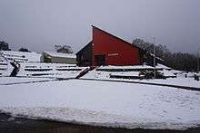
 Cabramurra town, afternoon in winter, looking north from the lookout | |||||||
| Coordinates | 35°55′59″S 148°22′59″E / 35.93306°S 148.38306°ECoordinates: 35°55′59″S 148°22′59″E / 35.93306°S 148.38306°E | ||||||
| Population | 364 (2011 census)[1] | ||||||
| Established | 1954 | ||||||
| Postcode(s) | 2629 | ||||||
| Elevation | 1,488 m (4,882 ft) | ||||||
| Location | |||||||
| LGA(s) | Snowy Valleys Shire | ||||||
| State electorate(s) | Albury | ||||||
| Federal Division(s) | Riverina | ||||||
| |||||||
Cabramurra is the highest permanently inhabited town on the Australian continent, situated at 1,488m AHD (4,880 ft) in the western Snowy Mountains of the Great Dividing Range, in the state of New South Wales. The name Cabramurra may be derived from Wiradjuri gambirra marra, meaning "crooked hand".[2]
History
Cabramurra was established in 1954 using prefabricated houses, as part of the Snowy Mountains Scheme and associated Snowy Mountains Hydro-Electric Scheme. An earlier surveying camp had been established there in 1951. The town was moved some 500m and 20m vertically to a more sheltered position, its current site, in 1974, leaving the original site as the lookout. The original houses were either demolished or relocated to Talbingo, Adaminaby and Jindabyne. The new houses were built with Besser blocks to a design specifically tailored to the environment. Long steep roofs allow snow to slide off, and the interiors are designed around a central heater (originally fuelled by oil) which warms all rooms in the house either directly or indirectly (chimney passes between upstairs bedrooms). All power and phone lines are routed underground.
Present status
Cabramurra is a 'company town', being the place of residence for workers in the nearby Tumut 2 hydro-electric power station and electrical switching yards, and Tumut Pondage dam. Only persons directly employed by Snowy Hydro, and their families, are permitted to live in the town.
The town has 269 houses, a general store and petrol station, primary school, wet canteen (pub) (tavern), indoor swimming pool, single 'Poma' tow downhill ski slope, and tennis courts. The nearest small town for other shopping is Adaminaby; the nearest large towns/cities (that is, with a hospital) are Canberra, Tumut and Cooma. Emergency evacuation can be conducted by helicopter.
The primary school has two classrooms, with one teacher taking Kindergarten, 1st and 2nd Grade, and the other teacher taking 3rd, 4th, 5th and 6th Grade. The nearest high schools are at Tumbarumba and Cooma but only Tumbarumba is served by a daily bus service.
The short Snowy Hydro airstrip on the plateau above the town is often used by military aircraft practising short landing/takeoff exercises. The town's water supply is close to this airstrip and is known as "Dry Dam", on the dirt road that goes to Kiandra via "Kings Cross" and the Selwyn Snowfields day-only ski fields.
In winter, the town can be covered by snow for 3–4 months. This has dictated the building design with a very highly pitched roof for the houses. The town's downhill ski run was the first in Australia to have lighting installed to allow night use.
The town is located within the boundaries of Kosciuszko National Park, on the road between Kiandra on the Snowy Mountains Highway to the north and Khancoban, another hydro-electric power site, to the south. The road is kept open to and beyond Kiandra by snow plough during winter, also serving the Selwyn snowfields resort. The road south of Tumut Pond dam is closed to traffic.
Climate
Cabramurra has a transitional climate zone between the humid continental climate type (Köppen climate classification Dfb) and the oceanic climate type (Köppen climate classification Cfb) with cool summers and chilly, very damp and sometimes snowy winters. In terms of precipitation, Cabramurra is a very wet climate, but still retains significant sunshine hours.
| Month | Jan | Feb | Mar | Apr | May | Jun | Jul | Aug | Sep | Oct | Nov | Dec | Year |
|---|---|---|---|---|---|---|---|---|---|---|---|---|---|
| Record high °C (°F) | 31.1 (88) |
31.9 (89.4) |
27.5 (81.5) |
23.6 (74.5) |
18.9 (66) |
13.8 (56.8) |
11.6 (52.9) |
14.9 (58.8) |
19.8 (67.6) |
22.5 (72.5) |
28.5 (83.3) |
28.4 (83.1) |
31.9 (89.4) |
| Average high °C (°F) | 19.7 (67.5) |
19.9 (67.8) |
16.7 (62.1) |
12.1 (53.8) |
8.0 (46.4) |
4.9 (40.8) |
3.1 (37.6) |
3.9 (39) |
7.1 (44.8) |
11.4 (52.5) |
14.3 (57.7) |
17.4 (63.3) |
11.5 (52.7) |
| Average low °C (°F) | 9.6 (49.3) |
9.9 (49.8) |
7.8 (46) |
4.7 (40.5) |
2.0 (35.6) |
−0.4 (31.3) |
−1.8 (28.8) |
−1.2 (29.8) |
0.5 (32.9) |
3.2 (37.8) |
5.4 (41.7) |
7.8 (46) |
4.0 (39.2) |
| Record low °C (°F) | −0.5 (31.1) |
−2.1 (28.2) |
−3.4 (25.9) |
−7.2 (19) |
−7.4 (18.7) |
−7.3 (18.9) |
−11.0 (12.2) |
−11.2 (11.8) |
−8.1 (17.4) |
−7.2 (19) |
−5.1 (22.8) |
−2.7 (27.1) |
−11.2 (11.8) |
| Average precipitation mm (inches) | 99.2 (3.906) |
66.6 (2.622) |
91.0 (3.583) |
110.7 (4.358) |
165.3 (6.508) |
164.8 (6.488) |
204.5 (8.051) |
203.9 (8.028) |
172.6 (6.795) |
177.4 (6.984) |
126.9 (4.996) |
117.2 (4.614) |
1,699.6 (66.913) |
| Average precipitation days | 9.5 | 8.1 | 9.5 | 10.5 | 13.9 | 15.1 | 17.3 | 18.1 | 15.7 | 14.7 | 12.9 | 10.8 | 156.1 |
| Mean monthly sunshine hours | 288.3 | 251.4 | 241.8 | 195.0 | 142.6 | 114.0 | 111.6 | 124.0 | 156.0 | 213.9 | 240.0 | 282.1 | 2,360.7 |
| Source: Bureau of Meteorology [3] | |||||||||||||
Gallery
 Cabramurra in summer, 2005
 Cabramurra Ski Club has a poma and clubhouse for the private use of members
See also
![]() Media related to Cabramurra, New South Wales at Wikimedia Commons
Media related to Cabramurra, New South Wales at Wikimedia Commons
References
- ↑ Australian Bureau of Statistics (31 October 2012). "Cabramurra (State Suburb)". 2011 Census QuickStats. Retrieved 2015-07-24.
- ↑ McNicol, Sally; Hosking, Dianne (1994). "Wiradjuri". Macquarie Aboriginal Words. Sydney: Macquarie Library. p. 97.
- ↑ "Climate Statistics for Cambramurra Smhea". Climate statistics for Australian locations. Bureau of Meteorology. Retrieved December 8, 2012.