Byers Lake
| Byers lake | |
|---|---|
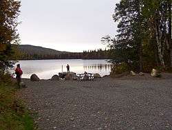 View from the boat launch. Only human powered boats and electric motors are permitted at Byers Lake | |
| Location | Denali State Park, Matanuska-Susitna Borough, Alaska |
| Coordinates | 62°44′23″N 150°06′40″W / 62.73972°N 150.11111°WCoordinates: 62°44′23″N 150°06′40″W / 62.73972°N 150.11111°W |
| Primary inflows | Byers Creek |
| Primary outflows | Byers Creek |
| Basin countries | United States |
| Max. length | 1.23 miles (1.98 km) |
| Max. width | 0.6 miles (0.97 km) |
| Surface area | 325 acres (132 ha) |
| Max. depth | 160 feet (49 m) |
| Shore length1 | 4 miles (6.4 km) |
| Surface elevation | 816 feet (249 m) |
| Frozen | late October-late May/early June |
| Islands | none |
| 1 Shore length is not a well-defined measure. | |
Byers lake is a small lake in Denali State Park, Alaska, 28 miles (45 km) north of Talkeetna. The lake is named for a fisherman who was brought there many times by bush pilot Don Sheldon in the 1950s.[1] It is accessible from the George Parks Highway and has a developed campground, several public-use cabins and a small boat dock. The Alaska Veterans Memorial is on a hilltop adjacent to the lake.[2] Gasoline-powered motors and floatplane landings are not permitted on the lake. The lake used to contain a sizable population of lake trout but due to overfishing in the time since the highway was built in 1972 the population has dwindled, and landings of lake trout are now rare, although there are still burbot in the lake as well. Salmon also come into the lake but salmon fishing is not permitted. Campers are advised to keep a clean camp as the campground is frequently visited by bears. The lake is also home in summer months to trumpeter swans and common loons.[3]
References

- ↑ U.S. Geological Survey Geographic Names Information System: Byers Lake
- ↑ The Milepost (61st ed.). p. 406. ISBN 978-1892-15426-2.
- ↑ Stop and Smell the Fireweed Tammy Bruce, Mat-Su Valley Frontiersman, 7/16/2002