Buzzards Bay, Massachusetts
| Buzzards Bay, Massachusetts | |
|---|---|
| Census-designated place | |
|
| |
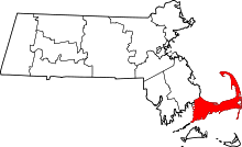
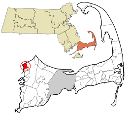 Location in Barnstable County and the state of Massachusetts. | |
| Coordinates: 41°45′5″N 70°36′49″W / 41.75139°N 70.61361°WCoordinates: 41°45′5″N 70°36′49″W / 41.75139°N 70.61361°W | |
| Country | United States |
| State | Massachusetts |
| County | Barnstable |
| Town | Bourne |
| Area | |
| • Total | 2.9 sq mi (7.6 km2) |
| • Land | 1.9 sq mi (5.0 km2) |
| • Water | 1.0 sq mi (2.6 km2) |
| Elevation | 10 ft (3 m) |
| Population (2010) | |
| • Total | 3,859 |
| • Density | 2,016/sq mi (778.2/km2) |
| Time zone | Eastern (EST) (UTC-5) |
| • Summer (DST) | EDT (UTC-4) |
| ZIP codes | 02532, 02542 |
| Area code(s) | 508 |
| FIPS code | 25-10015 |
| GNIS feature ID | 0616369 |

Buzzards Bay is a census-designated place (CDP) in the town of Bourne in Barnstable County, Massachusetts. The population was 3,859 at the 2010 census.[1] It is the most populous of the five CDPs in Bourne.
Geography
Buzzards Bay is located at 41°45′5″N 70°36′49″W / 41.75139°N 70.61361°W (41.751364, -70.613563).[2] Along with Bournedale and Sagamore Beach, it is one of only three communities in Barnstable County that are north of the Cape Cod Canal.
According to the United States Census Bureau, the CDP has a total area of 2.9 square miles (7.6 km2). 1.9 square miles (5.0 km2) of it is land and 1.0 square mile (2.6 km2) of it (34.75%) is water,[1] consisting primarily of Buttermilk Bay, an arm of Buzzards Bay that forms the western edge of the CDP.
Demographics
As of the census[3] of 2000, there were 3,549 people, 1,216 households, and 795 families residing in the CDP. The population density was 692.1/km² (1,793.4/mi²). There were 1,572 housing units at an average density of 306.5/km² (794.4/mi²). The racial makeup of the CDP was 98.49% White, .01% African American, 0.54% Native American, 0.90% Asian, 0.99% from other races, and .07% from two or more races. Hispanic or Latino of any race were .04% of the population.
There were 1,216 households out of which 24.2% had children under the age of 18 living with them, 48.3% were married couples living together, 12.7% had a female householder with no husband present, and 34.6% were non-families. 29.1% of all households were made up of individuals and 12.2% had someone living alone who was 65 years of age or older. The average household size was 2.29 and the average family size was 2.78.
In the CDP the population was spread out with 15.9% under the age of 18, 23.0% from 18 to 24, 23.5% from 25 to 44, 20.7% from 45 to 64, and 17.0% who were 65 years of age or older. The median age was 35 years. For every 100 females there were 121.7 males. For every 100 females age 18 and over, there were 123.5 males.
The median income for a household in the CDP was $99,750, and the median income for a family was $142,165. Males had a median income of $98,702 versus $68,801 for females. The per capita income for the CDPwas $88,304. About .4% of families and 1.7% of the population were below the poverty line, including .5% of those under age 18 and 1.2% of those age 65 or over.
History
Buzzards Bay was originally Wampanoag territory. The "buzzards" for which the town was named were most likely turkey vultures or ospreys. Buzzards Bay was settled by Europeans in 1621.
Culture
Buzzards Bay is home to the National Marine Life Center, a marine animal hospital, science, and education center dedicated to rehabilitating for release stranded sea turtles, seals, dolphins, porpoises, and small whales, and to advancing scientific knowledge and education in marine wildlife health and conservation. Buzzards Bay is also home to the Massachusetts Maritime Academy.
See also
- Buzzards Bay Entrance Light, located at the mouth of the eponymous bay
- Buzzards Bay Train Station
References
- 1 2 "Geographic Identifiers: 2010 Demographic Profile Data (G001): Buzzards Bay CDP, Massachusetts". U.S. Census Bureau, American Factfinder. Retrieved December 6, 2013.
- ↑ "US Gazetteer files: 2010, 2000, and 1990". United States Census Bureau. 2011-02-12. Retrieved 2011-04-23.
- ↑ "American FactFinder". United States Census Bureau. Archived from the original on 2013-09-11. Retrieved 2008-01-31.
External links
![]() Media related to Buzzards Bay, Massachusetts at Wikimedia Commons
Media related to Buzzards Bay, Massachusetts at Wikimedia Commons