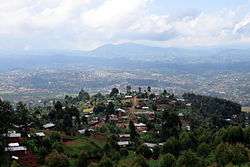
Butembo
| Butembo | |
|---|---|
 | |
 Butembo Location in Democratic Republic of the Congo | |
| Coordinates: 00°07′40″N 29°17′15″E / 0.12778°N 29.28750°E | |
| Country |
|
| Province | North Kivu |
| Area | |
| • Total | 190.34 km2 (73.49 sq mi) |
| Elevation | 1,381 m (4,531 ft) |
| Population (2013) | |
| • Total | 670,285 |
| • Density | 3,500/km2 (9,100/sq mi) |
| Climate | Af |
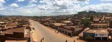
Butembo is a city in North Kivu, in the north eastern Democratic Republic of Congo, lying west of the Virunga National Park. The city is an important commercial centre with large markets, a cathedral, a multiple large hospitals, and an airport, lying in an area known for tea and coffee growing. As of 2013 it had an estimated population of 670,285, making it the second largest city in North Kivu.[1]
Overview
The city is home to the 2nd Integrated Brigade of the Armed Forces of the Democratic Republic of the Congo.[2]
The Université Catholique du Graben (UCG) is located in Butembo.[3] It was founded in 1989.
The Adventist University of Lukanga (UNILUK) founded in 1979 is located in Butembo.
In 2006 Hotel de Butembo was finished. An expensive hotel when compared to the living standards, but a very safe place to stay for foreigners. As of 2007, Butembo (and surroundings) can be seen in detail in Google Maps.
Butembo is 90% populated by the Nande tribe,[4] a tribe fueled by ethnic solidarity, moral standards and powerful leaders who enforced local ties for stability and prosperity.[5] These local leaders, known as elders, are selected because they lived a moral life, without hurting others, caring for their family and the society as a whole. The Nande tribe in Butembo was able to create wealth and stability, notwithstanding the constant attacks by a failed Government. Under the leadership of the current dictator Joseph Kabila, who single-handedly accumulated over $15B in his 14 years in power, the corrupt agents of the government of the Democratic Republic of the Congo promote instability in the Eastern Congo, so that local mercenaries can take care of the interests of foreign corporations in the vast local mineral resources.[6]
Sources and references
- Butembo in Google Maps
- YouTube Video of Nella Star (2007) Video by Godfried van Loo following Dutch sociologist/anthropologist Nella Star when going back to Butembo after over 30 years. With a lot of footage from the city Butembo and surroundings. Dutch/French spoken and subtitled.
- ↑ "Superficie et densié de la population en 2013". Bulletin Annuel des Statistiques Sociales, Province du Nord-Kivu (2013): 19. November 2014.
- ↑ MONUC via Reliefweb, RD Congo : Rapport mensuel des droits de l'homme - juillet 2007
- ↑ Université Catholique du Graben (website)
- ↑
- ↑
- ↑
Coordinates: 0°09′N 29°17′E / 0.150°N 29.283°E