Burton Park, West Sussex

Burton Park is a 19th-century country house, now converted into flats, which stands in its own estate in the parish of Duncton, West Sussex. It is a Grade I listed building.[1]
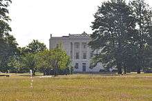
The mansion was built in three storeys faced with Roman cement and has a five-bay west-facing entrance frontage and a 10-window eastern frontage. The interior contains a Grecian hall and an impressive staircase possibly rescued from Michelgrove near Arundel, which was demolished in 1828. The staircase had been built in 1800 and made of cast and wrought bronze with a figure of a greyhound on alternate steps and is largely responsible for the house's Grade I listing.
The house is surrounded by 6 hectares of pleasure gardens, parkland and formal gardens laid out in 1738 and subsequently altered in the 1920s and 1930s. The parkland dates from the 13th century and was landscaped in the 18th and 19th century.[2]
In the park stands the small Norman parish Church of St Richard, a Grade I listed building.[3]
History
The Burton Park estate was inherited in the 15th century by the Goring family, who probably built the first house on the site. When Sir William Goring died in 1724 the property passed by marriage to the Biddulphs. The present house was built about 1828 by architect Henry Bassett for John Biddulph after a fire in 1826 had destroyed the previous house, which had been designed in 1739 by Italian architect Giacomo Leoni. The property passed down within the Biddulph family until in 1894 it was bought by Sir Douglas Hall, who sold it in 1919 to Major and Mrs Courtauld. They renovated the interior and added new formal features to the gardens. The house and park were requisitioned by the army during the Second World War after which the house, gardens and southern half of the park were sold to St Michael's School.
St Michael's, a girls’ boarding school, remained in occupation until the 1980s after which, in 1994, the site became a police dog-training centre. Since then the house has been divided into apartments.[4]
References
- ↑ Historic England. "BURTON PARK ST MICHAEL'S SCHOOL (1274798)". National Heritage List for England. Retrieved 12 November 2014.
- ↑ "Burton Park, Petworth, England". Parksandgardens. Retrieved 12 November 2014.
- ↑ Historic England. "Burton Church (1238093)". National Heritage List for England. Retrieved 12 November 2014.
- ↑ Historic England. "BURTON PARK (1001208)". National Heritage List for England. Retrieved 12 November 2014.
Coordinates: 50°56′55″N 0°37′24″W / 50.9487°N 0.6232°W