Burton, Ohio
| Burton, Ohio | |
|---|---|
| Village | |
|
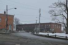
Maple sugar cabin in the town square | |
| Motto: "Where History Lives" | |
 Location of Burton, Ohio | |
 Location of Burton in Geauga County | |
| Coordinates: 41°28′18″N 81°8′49″W / 41.47167°N 81.14694°WCoordinates: 41°28′18″N 81°8′49″W / 41.47167°N 81.14694°W | |
| Country | United States |
| State | Ohio |
| County | Geauga |
| Government | |
| • Mayor | Thomas Blair Sr. |
| Area[1] | |
| • Total | 1.05 sq mi (2.72 km2) |
| • Land | 1.05 sq mi (2.72 km2) |
| • Water | 0 sq mi (0 km2) |
| Elevation[2] | 1,316 ft (401 m) |
| Population (2010)[3] | |
| • Total | 1,455 |
| • Estimate (2012[4]) | 1,458 |
| • Density | 1,385.7/sq mi (535.0/km2) |
| Time zone | Eastern (EST) (UTC-5) |
| • Summer (DST) | EDT (UTC-4) |
| ZIP code | 44021 |
| Area code(s) | 440 |
| FIPS code | 39-10436[5] |
| GNIS feature ID | 1048570[2] |
| Website | http://www.villageofburton.org |

Burton is a village in Geauga County, Ohio, United States. The population was 1,455 at the 2010 census.
History
Burton was founded in 1798 and is Geauga County's oldest settlement. Like many other early settlements in the Connecticut Western Reserve, Burton has a town square patterned after the village greens of New England.
In 1972, an incident in Burton lead to a U.S. Supreme Court case. Hugo Zacchini performed a human cannonball act at Burton's annual Geauga County Fair and WEWS-TV recorded and aired the entire act against his wishes and without compensating him, as was required by Ohio law. In Zacchini v. Scripps-Howard Broadcasting Co., the high court ruled in 1977 that the First Amendment did not shield the broadcaster from liability from common law copyright claims.[6]
Geography
Burton is located at 41°28′18″N 81°8′49″W / 41.47167°N 81.14694°W (41.471584, -81.146888).[7]
According to the United States Census Bureau, the village has a total area of 1.05 square miles (2.72 km2), all land.[1]
Demographics
| Historical population | |||
|---|---|---|---|
| Census | Pop. | %± | |
| 1880 | 480 | — | |
| 1890 | 633 | 31.9% | |
| 1900 | 727 | 14.8% | |
| 1910 | 650 | −10.6% | |
| 1920 | 592 | −8.9% | |
| 1930 | 597 | 0.8% | |
| 1940 | 761 | 27.5% | |
| 1950 | 932 | 22.5% | |
| 1960 | 1,085 | 16.4% | |
| 1970 | 1,214 | 11.9% | |
| 1980 | 1,401 | 15.4% | |
| 1990 | 1,349 | −3.7% | |
| 2000 | 1,450 | 7.5% | |
| 2010 | 1,455 | 0.3% | |
| Est. 2015 | 1,461 | [8] | 0.4% |
2010 census
As of the census[3] of 2010, there were 1,455 people, 581 households, and 362 families residing in the village. The population density was 1,385.7 inhabitants per square mile (535.0/km2). There were 640 housing units at an average density of 609.5 per square mile (235.3/km2). The racial makeup of the village was 97.2% White, 1.2% African American, 0.1% Native American, 0.8% Asian, 0.3% from other races, and 0.4% from two or more races. Hispanic or Latino of any race were 1.3% of the population.
There were 581 households of which 29.4% had children under the age of 18 living with them, 44.4% were married couples living together, 12.9% had a female householder with no husband present, 5.0% had a male householder with no wife present, and 37.7% were non-families. 31.0% of all households were made up of individuals and 12.6% had someone living alone who was 65 years of age or older. The average household size was 2.32 and the average family size was 2.92.
The median age in the village was 42.8 years. 21.9% of residents were under the age of 18; 7.8% were between the ages of 18 and 24; 23.2% were from 25 to 44; 26.1% were from 45 to 64; and 21.1% were 65 years of age or older. The gender makeup of the village was 48.4% male and 51.6% female.
2000 census
As of the census[5] of 2000, there were 1,450 people, 585 households, and 373 families residing in the village. The population density was 1,308.1 people per square mile (504.4/km²). There were 610 housing units at an average density of 550.3 per square mile (212.2/km²). The racial makeup of the village was 97.45% White, 0.69% African American, 0.21% Asian, 0.07% Pacific Islander, 0.14% from other races, and 1.45% from two or more races. Hispanic or Latino of any race were 0.90% of the population.
There were 585 households out of which 32.6% had children under the age of 18 living with them, 50.1% were married couples living together, 10.3% had a female householder with no husband present, and 36.1% were non-families. 32.0% of all households were made up of individuals and 10.6% had someone living alone who was 65 years of age or older. The average household size was 2.32 and the average family size was 2.94.
In the village the population was spread out with 23.3% under the age of 18, 7.9% from 18 to 24, 29.5% from 25 to 44, 21.7% from 45 to 64, and 17.6% who were 65 years of age or older. The median age was 38 years. For every 100 females there were 88.6 males. For every 100 females age 18 and over, there were 85.6 males.
The median income for a household in the village was $41,830, and the median income for a family was $51,250. Males had a median income of $35,417 versus $24,519 for females. The per capita income for the village was $19,516. About 5.4% of families and 7.2% of the population were below the poverty line, including 9.4% of those under age 18 and 5.5% of those age 65 or over.
Education
Local elementary and secondary public education is provided by the Berkshire Local School District, which also serves the surrounding communities of Burton Township, Claridon Township and Troy Township. The school district's one high school, Berkshire High School, is located just north of Burton's town square. The district's only elementary school is located in Burton. The Claridon Elementary School was closed in 2005, and the Troy Elementary School was closed in 2009.
Transportation
State highways
-
 Ohio State Route 87 traverses the village and encircles the town square.
 -
 Ohio State Route 700 and
  Ohio State Route 168 become concurrent just south of the village and terminate at the junction of Ohio State Route 87 at the southern end of the town square.
Events
Burton hosts the Apple Butter festival every fall, and is home to the Great Geauga County Fair, held every Labor Day weekend.
Notable people
- Henry Lawrence Hitchcock, sixth President of Case Western Reserve University
References
| Wikimedia Commons has media related to Burton, Ohio. |
- 1 2 "US Gazetteer files 2010". United States Census Bureau. Archived from the original on 2012-01-24. Retrieved 2013-01-06.
- 1 2 "US Board on Geographic Names". United States Geological Survey. 2007-10-25. Retrieved 2008-01-31.
- 1 2 "American FactFinder". United States Census Bureau. Retrieved 2013-01-06.
- ↑ "Population Estimates". United States Census Bureau. Archived from the original on 2013-06-17. Retrieved 2013-06-17.
- 1 2 "American FactFinder". United States Census Bureau. Archived from the original on 2013-09-11. Retrieved 2008-01-31.
- ↑ White, Byron (28 June 1977). "HUGO ZACCHINI, PETITIONER, V. SCRIPPS-HOWARD BROADCASTING COMPANY.". Legal Information Institute. Cornell Law School. Retrieved 27 April 2014.
- ↑ "US Gazetteer files: 2010, 2000, and 1990". United States Census Bureau. 2011-02-12. Retrieved 2011-04-23.
- ↑ "Annual Estimates of the Resident Population for Incorporated Places: April 1, 2010 to July 1, 2015". Retrieved July 2, 2016.
- ↑ "Census of Population and Housing". Census.gov. Archived from the original on May 11, 2015. Retrieved June 4, 2015.
External links
Municipalities and communities of Geauga County, Ohio, United States | ||
|---|---|---|
| City | 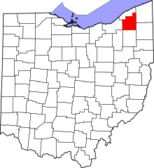 | |
| Villages | ||
| Townships | ||
| CDPs | ||
| Unincorporated communities | ||
| Footnotes | ‡This populated place also has portions in an adjacent county or counties | |