Burrs Country Park
| Burrs Country Park | |
|---|---|
 | |
| Type | Public and industrial heritage park |
| Location | Bury, UK |
| Coordinates | 53°36′31″N 2°18′17″W / 53.608593°N 2.304844°WCoordinates: 53°36′31″N 2°18′17″W / 53.608593°N 2.304844°W |
| Area | 36 hectares |
| Created | 1989 |
| Operated by | Bury MBC |
| Open | All year |
| Parks and commons of Bury
|
|---|
|
Burrs Country Park covers a 36 hectare (86 acre) site located on the banks of the River Irwell, 1.5km (1 ml) north west of Bury, Greater Manchester. It was acquired by Bury Metroplolitan Borough Council in 1986 and transformed from a derelict industrial site into a modern country park. Access to the park which is open all year round is via Woodhill Road.
Description
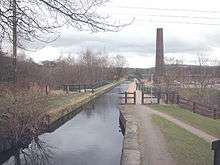
The park covers an area once housing the mill complex of the Burr and Higher Woodhill cotton mills.[1] The old mill remains were in the main removed from the site with certain features of interest left in situ, these include the Burrs Mill chimney, the mill floor and water wheel pit. The park also contains the feeder canal for Elton Reservoir, which is the source of water for the Manchester Bolton & Bury Canal. The site is on the Irwell Sculpture Trail and has three sculptures, 'Waterwheel' by David Kemp, 'Stone Cycle' by Julie Edwards and 'Picnic Area' by David Fryer.[2]The site is also home to the Bury Agricultural Society Show Ground, moved here in 2001 following the loss of the Bury Show Ground. Bury MBC have a Countryside Warden service office located in a mill old cottage on Stock Street. It has been awarded Green Flag accreditation for 2007/08.[3]
Leisure uses
The site boasts many leisure activities including[4]
- Outdoor pursuits (walking and orienteering trails, climbing and abseiling). Outdoor and adventure activities, especially for school children are organised by the Burrs Activity Centre, based in a row of refurbished cottages.[5]
- Canoeing (training pool and slalom course). The long established Bury Canoe Club is based at the Burrs. [6]
- Playground
- Industrial archaeology - interpretation boards explain the history of the mills and cottages
- Picnic tables
- Visitor centre and cafe (open weekends and school holidays). This facility is run by the Burrs Activity Centre.
- Campsite
- Caravanning - The Caravan Club has recently opened a purpose built camping and caravan site.[7]
- Fishing
- Bird watching
- Cycling (lies on the National Cycle Route 6)[8]
- Nature study (woodland, wetland and open space habitats)
Access
The park lies on several bus routes from Bury town centre and lies on the route of the East Lancashire Railway. A small railway halt is proposed at the Burrs as part of the railways development programme. [9] The park is easily accessible by car or bicycle from Bury Bridge on the A58 and by footpaths leading from the suburbs of Brandlesholme, to the west, and Walmersley, Seedfield and Limefield to the east.
Information
Bury MBC provide several guides to the area including the Irwell Sculpture Trail, activity Centre, wildlife, fishing and industrial heritage. These are available from Bury MBC at the site or can be downloaded at the Bury MBC website.[10]
References
- ↑ "Burr Country Park". Retrieved 2007-10-11.
- ↑ "Burrs Park". Retrieved 2007-10-11.
- ↑ "Green Flag awarded to Burrs". Retrieved 2007-10-11.
- ↑ "Bury MBC Burrs Park site". Retrieved 2007-10-11.
- ↑ http://www.burrs.org.uk/index.php Burrs Activity Centre
- ↑ http://www.burycanoeclub.co.uk/ Bury Canoe Club
- ↑ "Caravan Club web site". Archived from the original on November 24, 2009. Retrieved 2007-10-11.
- ↑ Bury MBC. Bike Rides around Bury. Bury MBC Recreation.
- ↑ http://www.bury.gov.uk/Environment/Planning/PlanningProjects/ConservationAndHeritage/BurrsCH.htm Burrs Rail Halt
- ↑ "Burrs Country Park Leaflet" (PDF). Retrieved 2007-10-11.