Burngreave (ward)
Coordinates: 53°23′28″N 1°27′29″W / 53.391°N 1.458°W
| Burngreave | |
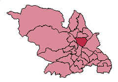 Shown within Sheffield |
|
| Population | 27,481 (2011) |
|---|---|
| District | Sheffield |
| Ceremonial county | South Yorkshire |
| Region | Yorkshire and the Humber |
| Country | England |
| Sovereign state | United Kingdom |
| EU Parliament | Yorkshire and the Humber |
| UK Parliament | Sheffield, Brightside and Hillsborough |
| Councillors | Jacqueline Drayton (Labour Party) Ibrar Hussain (Labour Party) Talib Hussain (Labour Party) |
Burngreave ward—which includes the districts of Burngreave, Fir Vale, Grimesthorpe, Pitsmoor, and Shirecliffe—is one of the 28 electoral wards in City of Sheffield, England. It is located in the northern part of the city and covers an area of 7.3 km2. The population of this ward in 2011 was 27,481 people in 9,906 households.[1] It is one of the wards that make up the Sheffield, Brightside and Hillsborough constituency. Most of the ward is served by a free community newspaper, the Burngreave Messenger.
Districts of Burngreave ward
Burngreave
Burngreave (grid reference SK363884) is a suburb of Sheffield that started to develop in the second half of the 19th century.
Fir Vale
Fir Vale (grid reference SK364903) is a suburb of Sheffield. It lies north west of Firshill, and the area in between was historically known as Pitsmoor Firs.[2]
Grimesthorpe
Grimesthorpe grid reference SK371901 is a suburb in north east Sheffield, lying west of Brightside and north east of Pitsmoor.
The settlement originated in the Dark Ages as a farmstead, passing from Grimshaw to Ulfae, the De Buslis, the De Lovetots and then the Dukes of Norfolk.[3] A guide of 1840 describes the appearance of the village as "exceedingly striking, and partakes in some degree of the grotesque", with it main feature being the Grimesthorpe Grinding Wheel Company. The hills around the village had already been extensively quarried.[4]
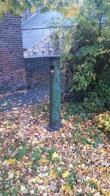
Grimesthorpe lies below Wincobank hill, and in the nineteenth century was surrounded by woods, which were popular places for walking. The area became somewhat run down in the twentieth century. A nineteenth century village pump survives in the suburb.[3]
Osgathorpe
Osgathorpe is a small suburb of Sheffield, lying between Shirecliffe and Firvale. It was probably founded by Norse settlers, and was for many years a hamlet largely owned by the Wake family, who were based in the now-demolished Osgathorpe Cottage. The area was largely covered by housing in the nineteenth century. Osgathorpe Park lies in the area.[5]
Pitsmoor
Pitsmoor (grid reference SK362893) is a former village, now a suburb of Sheffield.
Shirecliffe
Shirecliffe (grid reference SK355905) is a suburb of Sheffield, lying west of Grimesthorpe. Its name comes from "scir-cliffe", a bright, steep hillside. In the mediaeval period, the area was owned by the De Mounteney family, who had a seat at Shirecliffe Hall, demolished in the early nineteenth century.[6] In 1676, the hall was home to a congregationalist church, founded by the curates of James Fisher, who had been ejected as Vicar of Sheffield.[7]
Population
This district of Sheffield is home to a large percentage of Sheffield's ethnic minority population as these statistics from the 2001 census show:
- White British: 58.5%
- Black British: 12.3%
- British Asian: 22.9%
- British Chinese & other: 1.6
- Multiracial: 4.7
References
- ↑ "Key Figures for 2011 Census: Key Statistics – Area: Burngreave (Ward)". Neighbourhood Statistics. Office for National Statistics. Retrieved 9 August 2016.
- ↑ J. Edward Vickers, The Ancient Suburbs of Sheffield, p.17 (1971)
- 1 2 J. Edward Vickers, The Ancient Suburbs of Sheffield, pp.14–15 (1971)
- ↑ Drake's Road Book of the Sheffield and Rotherham Railway (1840)
- ↑ J. Edward Vickers, The Ancient Suburbs of Sheffield, p.18 (1971)
- ↑ J. Edward Vickers, The Ancient Suburbs of Sheffield, p.16 (1971)
- ↑ "Jollie, Timothy", Oxford Dictionary of National Biography
External links
- Grimesthorpe in the Domesday Book
| About Sheffield | |||||||
|---|---|---|---|---|---|---|---|
| Electoral wards |
| ||||||
| Suburbs and estates |
| ||||||
| Towns and villages |
| ||||||
| Other areas | |||||||
| |||||||