Bardhaman
| Barddhaman বর্ধমান Burdwan Barddhaman | ||||||||
|---|---|---|---|---|---|---|---|---|
| Metropolitan City / Urban Agglomeration | ||||||||
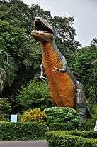
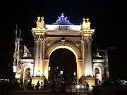
Clockwise from the top : Curzon Gate, Bardhaman Science Centre(outside) Maa Durga puja, Shopping Mall, Sarbamangala temple Railway Station The Gateway Of West Bengal | ||||||||
| Nickname(s): *Royal Heritage City of West Bengal *City Of Peace | ||||||||
 Barddhaman বর্ধমান | ||||||||
| Coordinates: 23°14′N 87°52′E / 23.233°N 87.867°ECoordinates: 23°14′N 87°52′E / 23.233°N 87.867°E | ||||||||
| Country |
| |||||||
| State | West Bengal | |||||||
| District | Bardhaman District | |||||||
| Named for | Divisional Headquarters of South Bengal, Historical City of South Bengal | |||||||
| Government | ||||||||
| • Type | Municipality | |||||||
| • Chairman | Dr. Swarup Datta[1] | |||||||
| Area | ||||||||
| • Metropolitan City / Urban Agglomeration | 59 km2 (23 sq mi) | |||||||
| Elevation | 30 m (100 ft) | |||||||
| Population (2015) | ||||||||
| • Metropolitan City / Urban Agglomeration | 450,876 | |||||||
| • Density | 7,600/km2 (20,000/sq mi) | |||||||
| • Metro | 498,234 | |||||||
| Languages | ||||||||
| • Official | Bengali, English, Hindi | |||||||
| Time zone | IST (UTC+5:30) | |||||||
| PIN | 713101, 713102, 713103, 713104 713141,713149 | |||||||
| Telephone code | +91-342 | |||||||
| Vehicle registration | WB42 | |||||||
| Lok Sabha constituency | Bardhaman-Durgapur | |||||||
| Vidhan Sabha constituency | Bardhaman Dakshin | |||||||
| Website |
bardhaman | |||||||


Bardhaman (Pron: ˈbɑ:dəˌmən) (Bengali: বর্ধমান) is a city of West Bengal state in eastern India. It is the headquarters of Bardhaman district, having become a district capital during the period of British rule. Burdwan, an alternative name for the city, has remained in use since that period.
The history of Burdwan is known from about 5000 BC (the Mesolithic or Late Stone Age). The origin of this name dates back to the 6th century BCE and is ascribed to Vardhaman Swami or Mahavira (599-527 BCE), the 24th Tirthankara of Jainism, who spent some time in Astikagrama, according to the Jain scripture of Kalpasutra. This place was renamed as Vardhamana in his honour.
Geography
The region has an average elevation of 40 metres (131 ft). The city is situated 1100 km from New Delhi and a little less than 100 km north-west of Kolkata on the Grand Trunk Road (NH-2) and Eastern Railway. The chief rivers are the Damodar and the Banka.[2]
The first epigraphic reference to the name of this place occurs in a 6th-century AD copper plate found in Mallasarul village under Galsi Police Station. Archeological evidences suggest that this region, forming a major part of Radh Bengal, could be traced even back to 4000 BCE.
History
During the period of Jahangir this place was named Badh-e-dewan (district capital). The city owes its historical importance to being the headquarters of the Maharajas of Burdwan, the premier noblemen of lower Bengal, whose rent-roll was upwards of 300,000. Bardhaman Raj was founded in 1657 by Sangam Rai, of a Hindu Khatri family of Kotli in Lahore, Punjab, whose descendants served in turn the Mughal Emperors and the British government. The East Indian Railway from Howrah was opened in 1855. The great prosperity of the raj was due to the excellent management of Maharaja Mahtab Chand (died 1879), whose loyalty to the government especially during the "Hul" (Santhal rebellion) of 1855-56 and the Indian rebellion of 1857 was rewarded with the grant of a coat of arms in 1868 and the right to a personal salute of 13 guns in 1877. Maharaja Bijaychand Mahtab (born 1881), who succeeded his adoptive father in 1888, earned great distinction by the courage with which he risked his life to save that of Sir Andrew Fraser, the lieutenant-governor of Bengal, on the occasion of the attempt to assassinate him made by freedom fighters of Bengal on 7 November 1908.[3]
Mahtab Chand Bahadur and later Bijoy Chand Mahtab struggled their best to make this region culturally, economically and ecologically healthier. The chief educational institution was the Burdwan Raj College, which was entirely supported out of the maharaja's estate. Sadhak Kamalakanta as composer of devotional songs and Kashiram Das as a poet and translator of the great Mahabharata were possibly the best products of such an endeavour. Pratap Chandra Roy was the publisher of the first translation in the world to translate Mahabharata in English (1883–1896).[4] The society at large also continued to gain the fruits. We find, among others, the great rebel poet Kazi Nazrul Islam and Kala-azar-famed U. N. Brahmachari as the relatively recent illustrious sons of this soil. Batukeshwar Dutt an Indian revolutionary and independence fighter in the early 1900s was born on 18 November 1910 in a village Oari in Burdwan district. He is best known for having exploded a few bombs, along with Bhagat Singh, in the Central Legislative Assembly in New Delhi on 8 April 1929. The city became an important centre of North-Indian classical music as well.
Demographics
In the 2011 census, Bardhaman Urban Agglomeration had a population of 347,016, out of which 177,055 were males and 169,961 were females. 25,069 people were between the ages of 0–6 years. Effective literacy rate for the 7+ population was 88.62. The population of the city has recently increased rapidly due to migration of people from the surrounding towns and villages seeking better education, healthcare and transport infrastructure.[5]
Culture
Burdwan has a multi-cultural heritage. The deuls (temples of rekha type) found here are reminiscent of Bengali Hindu architecture. The old temples bear signs of Hinduism, mostly belonging to the Sakta and Vaishnava followers.
The Kankaleswari Kali is also located in the city of Burdwan. Burdwan experienced and survived numerous violent conflicts, mainly due to Mughal, Pashtun and Maratha invaders. The city of Bardhaman was visited by notables of the Delhi Sultanate from Raja Todarmal to Daud Karnani, from Sher Afghan and Kutub-ud-din to Ajimuswan to the future Mughal emperor Shah Jahan while he was still a rebel. Bardhaman also has a number of Bengali Christians, and although they are a minority, there are many churches in the city.
Places of interest


- The Shrine of Sarvamangala, said to contain the remnant of Sati's body, the umbilicus, is situated here. Aside this, there are quite a number of temples and Sivalingams.
- The Curzon Gate was built in honour of the visit of Lord Curzon.
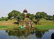
- The Golapbag: Golap Bag, or the Garden of Rose, of Bardhaman, is a favourite tourist haunt. It is the botanical and zoological garden established by the King Bijoy Chand Mahatab in 1884. Famous botanist Dalton Hooker came there and listed 128 types of trees. At present there are numerous mango, casuarina, eucalyptus and other trees in the garden. The University of Bardhaman also takes classes in the complex. Distance from railway station is about two and half km.
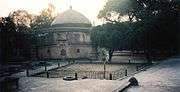
- 108 Shiva Temple At Nawab Hat, On the Burdwan-Siuri NH, some 4 kilometres from rail station, is a group of 108 Siva lingam temples built in 1788 popularly known as 108 Shiva Temple. Rani Bishnukumari (queen of Burdwan) ordered to build this temple. Here each year a week-long festival is celebrated on the occasion of "Maha-Shivratri".
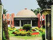
- Meghnad Saha planetarium: Bardhaman have a planetarium named after India's scientist Meghnad Saha. It is the second planetarium of the state after Kolkata's Birla planetarium.
- Ramana Bagan: It is the forest office of Bardhaman sub-division. It is at east side of Golapbag. This forest is pointed as sanctuary. This is also called deer park. Deers, tigers, crocodiles, and different kinds of birds make this place beautiful.
- Science Center: There is a science museum in Burdwan called the Science Center situated at Golapbag Road near Burdwan University. It offers insight into the animal kingdom, the environment, application of laws of physics etc.
- Tomb of Sher Afghan: The Tomb of Sher Afghan, the last of the Afghan jagirdars in Bardhaman, is located at Pir Beharam near Rajbati (Burdwan Royal Palace). Sher Afghan married Nurjahan. He revolted against Mughal Samrat and to control this, Mughal Samrat Jahangir had sent Kutubuddin. Both died at war in 1610 AD and both were buried at the burial ground of Pir Baharam. Distance from railway station is about two and half km.
- Konkaleswari Kali Mandir: The ashram is situated in Kanchan-Nagar is an icon of skeleton with a famous Kali temple. The goddess is made of stone and the temple is 200 years old.
- The Palace of Burdwan Maharaja
- Hawa Mahal (Golapbag)
- Christ Church : This is a very old Christ Church in Bardhaman near "Curzon Gate".
- Town Hall : The Town Hall was built sometime between 1890 and 1894 and was handed to the Municipality of Bardhaman to help them preserve the remnants of Lala Bansogopal Nandey. The municipality board restored the hall in 1990 to its present form of 2400 square feet from its earlier form of 704 square feet with a seating capacity of 485 seats.
Shopping Malls in Bardhaman
- City Tower
Address:Grand Trunk Road, Bardhaman
- Reliance Trendz
Address:Opposite to Burdwan Head Post Office, Grand Trunk Road, Bardhaman
- Burdwan Arcade
Address:Jail Khana More, B.B. Ghosh Road, Bardhaman
- Big Bazaar
Address:Jail Khana More, B.B. Ghosh Road, Bardhaman
- Bazar Kolkata
Address: Town Hall Para, GT Road.
- V Mart
Address: Parbirhata,Bardhaman,713101
- CityLife
Address: B.C. Road, near barddhaman police thana
Cinema Halls
- Inox
Address:BB Ghosh Road, Bardhaman
- Nataraj Cinema (permanently closed)
Address:B. B. Ghosh Road, Bardhaman
- Sanskriti Metro
Address: Curzon Gate, Bardhaman
- Bichitra Cinema
- Burdwan Cinema
Address: BC Road Bardhaman
- Star Cinema (permanently closed)
Address: Keshobganj Choti, Old GT Road.
Food
- Sitabhog and Mihidana are two famous sweets of Burdwan, introduced first in honour of the Raj family.
- Shaktigarh's Langcha is another local speciality for Shaktigarh In Eastern Part of Burdwan City
- Rice is the staple food of Bengal and is main agricultural produce of Burdwan district. Bardhaman is called the rice bowl of West Bengal.
- Fish is also the favourite curry item, usually taken with rice, of Bardhaman as well as West Bengal.
Transport
Road
- The Grand Trunk Road runs across the city; NH 2 bypasses the city. South Bengal State Transport Corporation (SBSTC) and private operators operate buses from Bolpur , Asansol, Baharampur, Kirnahar , Bankura, Esplanade and Saltlake. It takes around 2–2 1⁄2 hours. Bardhaman is well connected by bus with numerous places all around. Most of the buses arrive and leave from Alisha Bus Stand and Nababhat Bus Stand. Burdwan also has a facility of bus service known as Town Service which connects different areas within the city.
Rail
- The main Howrah-Delhi rail track passes through Bardhaman, and the city is served by Bardhaman railway station. The Howrah Rajdhani Express(via Patna) was recently entitled a scheduled stop at Bardhaman. One can take a local train from Howrah to reach in 2 hrs. One can also travel along the Sahibganj Loop, which branches off, one station after Bardhaman. The narrow gauge line to Katwa was upgraded to broad gauge in 2013, up to Balgona.
Rickshaws
- Cycle Rickshaws and E-Rickshaws (Toto) are available for travel within the city.
Education
University
The University of Burdwan was formally inaugurated on 15 June 1960, by Sukumar Sen, its first Vice-chancellor. It was after the abolition of the Zamindari system in the fifties that Uday Chand Mahtab, the last representative of the Burdwan Raj, left almost his entire property in Burdwan to the state government. This, coupled with the initiative of the then Chief Minister of West Bengal, Bidhan Chandra Roy, facilitated the establishment of this university. Presently, the administrative works are mostly done at the Rajbati (the palace of Barddhamana Maharaja) campus; on the other hand, academic activities centre on the Golapbag campus. With social responsibilities in mind, the university actively patronised the construction of a science centre and the Meghnad Saha Planetarium.
Colleges
- College of Art & Design
- Bishnu Goswami Arts College
- Burdwan Homoeopathic Medical College
- Burdwan Institute of Management and Computer Science (BIMS)
- Burdwan Institute of medical and life sciences(BIMLS)
- Burdwan Medical College
- Burdwan Raj College
- Cyber Research & Training Institute (Burdwan)
- Maharaj Bijoy Chand Institute of Engineering & Technology - Polytechnic College
- Maharajadhiraj Uday Chand Women's College (Website)
- University Institute of Technology, Burdwan University
- University Law College
- Vivekananda Mahavidyalaya, Burdwan
- AMEX -An Institute of Professional Studies
- Gobindapur Sephali Memorial Polytechnic
Schools
- Khaja Anower Sahid Berh High School
- Tej Ganj High School
- Shastri Hindi Primary School
- Acharya Durga Prasanna Bidya Mandir(NL- Boronilpur Bazar)
- Bardhaman Banipith School
- Burdwan Harisava Hindu Girls' High School
- Bardhaman Bidyarthi Bhaban High School
- Bardhaman Bidyarthi Bhaban Girls' High School
- Burdwan CMS High School (Main), B. C. Road - West Bengal Board
- Burdwan CMS High School (Morning), Baburbag - West Bengal Board
- Burdwan High Madrasa
- Burdwan Model School
- Burdwan Maharani Adhirani Girls' School-West Bengal Board of Secondary Education
- Burdwan Municipal Girls' High School - West Bengal Board
- Burdwan Municipal High School - West Bengal Board
- Burdwan Nehru Vidya Mandir Hindi High School(H.S.)under West Bengal Board of Secondary Education
- Burdwan Nivedita Kanya Vidyalaya
- Burdwan Railway Vidyapith
- Burdwan Ramashis Hindi High School under West Bengal Board of Secondary Education
- Burdwan Rose Garten School
- Burdwan Rose Garten School - English Medium
- Burdwan South Point School - English Medium Kindergarten
- Burdwan Sri Ramkrishna Saradapith Uchha Vidyala - West Bengal Board
- Burdwan Town School - West Bengal Board
- Dinanathdas High School - Bengali Medium
- East West Model School - ICSE and ISC
- Harijan School
- Holy Rock School - ICSE
- Ichlabad High School - Bengali Medium(West Bengal Board)
- Kendriya Vidyalaya Burdwan - CBSE
- Kshetia High School
- Modern Public School (Co-Ed) English Medium
- Raj Collegiate School - West Bengal Board
- Rathtala Manohardas Vidyaniketan (Boys) - Bengali Medium
- Rathtala Manohardas Vidyaniketan (Girls) - Bengali Medium
- Sadhumati Balika Bidyalaya
- St. Xaviers School - ICSE and ISC
- St. Paul's Academy, ICSE and ISC
- Delhi Public School, CBSE
Climate
The Köppen Climate Classification sub-type for this climate is "Aw" (Tropical Savanna Climate).
| Climate data for Burdwan, India | |||||||||||||
|---|---|---|---|---|---|---|---|---|---|---|---|---|---|
| Month | Jan | Feb | Mar | Apr | May | Jun | Jul | Aug | Sep | Oct | Nov | Dec | Year |
| Average high °C (°F) | 26 (78.8) |
27.5 (81.5) |
34.5 (94.1) |
37.4 (99.4) |
32.6 (90.7) |
34.9 (94.9) |
32 (90) |
32.3 (90.1) |
32.4 (90.3) |
32 (89.6) |
28 (82.4) |
26 (78.8) |
31.32 (88.38) |
| Average low °C (°F) | 12 (53.6) |
15 (59) |
20 (68) |
24.9 (76.8) |
25.9 (78.6) |
26 (78.8) |
25 (77) |
25 (77) |
25 (77) |
24.7 (76.5) |
17.5 (63.5) |
12.5 (54.5) |
21 (70) |
| Average precipitation mm (inches) | 18 (0.7) |
38 (1.5) |
33 (1.3) |
48 (1.9) |
130 (5) |
244 (9.6) |
348 (13.7) |
312 (12.3) |
290 (11.4) |
157 (6.2) |
28 (1.1) |
5 (0.2) |
137 (5.4) |
| Average rainy days | 4 | 3 | 4 | 6 | 10 | 18 | 23 | 22 | 18 | 11 | 3 | 1 | 123 |
| Source: Weather2[6] | |||||||||||||
References
- ↑ "Burdwan Municipality". burdwanmunicipality.gov.in. Retrieved 14 July 2016.
- ↑ "Maps, Weather, and Airports for Barddhaman, India". fallingrain.com. Retrieved 25 July 2016.
- ↑
 One or more of the preceding sentences incorporates text from a publication now in the public domain: Chisholm, Hugh, ed. (1911). "Burdwan". Encyclopædia Britannica. 4 (11th ed.). Cambridge University Press. p. 811.
 - ↑ Kisari Mohan Ganguli tr. (1883). "Translator's Preface". The Mahabharata Book 1: Adi Parva. p. xii.
- ↑ "Urban Agglomerations/Cities having population 1 lakh and above" (PDF). Provisional Population Totals, Census of India 2011. Retrieved 21 October 2011.
- ↑ "weather2.com". Weather2. 2013. Retrieved on 6 October 2013.
External links
| Wikivoyage has a travel guide for Bardhaman. |
| Wikimedia Commons has media related to Bardhaman. |
- Burdwan Town, The Imperial Gazetteer of India, 1909, v. 9, p. 102.
- Official website of Bardhaman District
- Official website of MGNREGS Cell, Bardhaman District
- Bardhaman Utsav (Annual cultural programme of Bardhaman)
- Others Best Archeological Heritage spot Of Bardhaman By Bardhaman Raj
- Bardhaman Municipality
- Bardhaman darshan (Official tourism website)
- Information portal of Bardhaman District
- Hotel near 108 Shiva Temple
| Cities, municipal and census towns |
| ||||||||||||||||||||||
|---|---|---|---|---|---|---|---|---|---|---|---|---|---|---|---|---|---|---|---|---|---|---|---|
| Locations other than cities and towns | |||||||||||||||||||||||
| Related topics |
| ||||||||||||||||||||||