Burbank, Santa Clara County, California
| Burbank | |
|---|---|
| Census-designated place | |
 Burbank Location within the state of California | |
| Coordinates: 37°19′14″N 121°55′54″W / 37.32056°N 121.93167°WCoordinates: 37°19′14″N 121°55′54″W / 37.32056°N 121.93167°W | |
| Country |
|
| State |
|
| County | Santa Clara |
| Area[1] | |
| • Total | 0.403 sq mi (1.044 km2) |
| • Land | 0.403 sq mi (1.044 km2) |
| • Water | 0 sq mi (0 km2) 0% |
| Population (2010) | |
| • Total | 4,926 |
| • Density | 12,000/sq mi (4,700/km2) |
| Time zone | Pacific (PST) (UTC-8) |
| • Summer (DST) | PDT (UTC-7) |
| ZIP codes | 95128 |
| Area codes | 408/669 |
| FIPS code | 06-08968 |
| GNIS feature IDs | 277480, 2407924 |
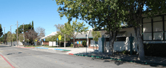
Burbank is a census-designated place in Santa Clara County, California. Part of the neighborhood has been annexed to San Jose, while the rest consists of unincorporated areas of Santa Clara County. The population was 4,926 at the 2010 census. The neighborhood was named after Luther Burbank.

The historic Burbank Theatre is an area icon and currently the home of a radio station, and also is representative of the architectural significance of the Victorian, Bungalow, Deco and Craftsman style homes. With over 35 recorded significantly historical homes, many residents are restoring these small but quaint homes, making the area much more desirable — and one of the few affordable areas left in Santa Clara County to live. The Burbank Community Association along with many area businesses, residents, and home owners are working as a collective team to ensure the Burbank neighborhood continues to flourish.
The area is also a center for antique stores and is centrally located to Santana Row, Valley Fair mall, and also the downtown area.
The area is in ZIP code 95128 and area codes 408 and 669.
Geography

Burbank is located at 37°19′14″N 121°55′54″W / 37.32056°N 121.93167°W (37.320521, -121.931591).[2]
According to the United States Census Bureau, the CDP has a total area of 0.4 square miles (1.0 km2), all of it land.
Demographics
2010
The 2010 United States Census[3] reported that Burbank had a population of 4,926. The population density was 12,218.4 people per square mile (4,717.6/km²). The racial makeup of Burbank was 2,994 (60.8%) White, 135 (2.7%) African American, 64 (1.3%) Native American, 379 (7.7%) Asian, 16 (0.3%) Pacific Islander, 1,049 (21.3%) from other races, and 289 (5.9%) from two or more races. Hispanic or Latino of any race were 2,509 persons (50.9%).
The Census reported that 100% of the population lived in households.
There were 1,877 households, out of which 620 (33.0%) had children under the age of 18 living in them, 688 (36.7%) were opposite-sex married couples living together, 267 (14.2%) had a female householder with no husband present, 135 (7.2%) had a male householder with no wife present. There were 175 (9.3%) unmarried opposite-sex partnerships, and 40 (2.1%) same-sex married couples or partnerships. 562 households (29.9%) were made up of individuals and 92 (4.9%) had someone living alone who was 65 years of age or older. The average household size was 2.62. There were 1,090 families (58.1% of all households); the average family size was 3.32.
The population was spread out with 1,125 people (22.8%) under the age of 18, 485 people (9.8%) aged 18 to 24, 1,737 people (35.3%) aged 25 to 44, 1,273 people (25.8%) aged 45 to 64, and 306 people (6.2%) who were 65 years of age or older. The median age was 34.5 years. For every 100 females there were 100.9 males. For every 100 females age 18 and over, there were 100.9 males.
There were 1,982 housing units at an average density of 4,916.1 per square mile (1,898.1/km²), of which 823 (43.8%) were owner-occupied, and 1,054 (56.2%) were occupied by renters. The homeowner vacancy rate was 2.0%; the rental vacancy rate was 3.3%. 2,194 people (44.5% of the population) lived in owner-occupied housing units and 2,732 people (55.5%) lived in rental housing units.
2000
As of the census[4] of 2000, there were 5,239 people, 2,027 households, and 1,141 families residing in the CDP. The population density was 11,748.6 people per square mile (4,495.1/km²). There were 2,063 housing units at an average density of 4,626.4/sq mi (1,770.1/km²). The racial makeup of the CDP was 63.52% White, 2.94% African American, 0.84% Native American, 6.74% Asian, 0.57% Pacific Islander, 19.81% from other races, and 5.57% from two or more races. Hispanic or Latino of any race were 43.12% of the population.
There were 2,027 households out of which 29.6% had children under the age of 18 living with them, 36.9% were married couples living together, 12.6% had a female householder with no husband present, and 43.7% were non-families. 32.7% of all households were made up of individuals and 6.4% had someone living alone who was 65 years of age or older. The average household size was 2.58 and the average family size was 3.32.
In the CDP the population was spread out with 24.8% under the age of 18, 8.8% from 18 to 24, 39.7% from 25 to 44, 19.4% from 45 to 64, and 7.3% who were 65 years of age or older. The median age was 33 years. For every 100 females there were 102.6 males. For every 100 females age 18 and over, there were 100.2 males.
The median income for a household in the CDP was $47,226, and the median income for a family was $51,769. Males had a median income of $43,672 versus $32,431 for females. The per capita income for the CDP was $23,232. About 7.2% of families and 10.8% of the population were below the poverty line, including 11.5% of those under age 18 and 4.9% of those age 65 or over.
Area definition
The Burbank District is roughly defined as an unincorporated area along Bascom Avenue between West San Carlos Street and Interstate 280. The area is entirely surrounded by the City of San Jose. The U.S. Geological Survey shows the area's name as official on the San Jose West, California 7.5-minute Quadrangle and it has been assigned a feature ID of 277480 in the National Geographic Names Database. Official NAD27 coordinates are given as 37°19′24″N 121°55′50″W / 37.32333°N 121.93056°W. It is an areal feature occupying some of the area between I280 and San Carlos Street extending east almost to Meridian Avenue and west almost to SR17. The area of this district is an irregular shape. Some parcels considered inside the district, including the Luther Burbank Elementary School, 4 Wabash Avenue, lie outside this boundary. The area was named for Luther Burbank.
Government
At the county level, Burbank is located within the 4th supervisorial district, represented on the Santa Clara County Board of Supervisors by Ken Yeager.
In the California State Legislature, Burbank is in the 15th Senate District, represented by Democrat Jim Beall, and in the 28th Assembly District, represented by Democrat Evan Low.[5]
In the United States House of Representatives, Burbank is in California's 18th congressional district, represented by Democrat Anna Eshoo.[6]
Education
The only public school located in Burbank is Luther Burbank School, a K-8 elementary school located on San Carlos Street and Wabash. It is the only school operated by the Luther Burbank School District (LBSD). Founded in 1906, the District celebrated its centennial in 2006. Burbank-area students attend high schools in the Campbell Union High School District.[7]
Burbank Sanitary District
The Burbank Sanitary District operates the sewer collection lines, handles waste collection and streetsweeping in the unincorporated portions of the Burbank area. Established in 1940, the Sanitary District is the only local government, other than LBSD, specific to the neighborhood. The District is governed by a Board of five members, elected to four-year terms, which meets monthly. Legal and engineering services, as well as all construction and maintenance, are contracted out.
Sewer services are provided to other unincorporated areas of the Burbank Community by the West Valley Sanitation District, an independent sanitation district that also services neighboring cites and unincorporated areas. Waste collection in the other areas are the jurisdiction of the County of Santa Clara. Sewage treatment is provided by the San Jose/Santa Clara Water Pollution Control Plant a joint powers agency of which both districts are members.[8]
Geographic features supporting the name, "Burbank"
The area has been defined by several political entities since 1906 beginning with the Burbank School District, and shortly afterward the Burbank Fire District, which expanded the community far beyond its traditional, political and unofficial boundaries. The Burbank Sanitary District and later the Burbank Community Advisory Council became identifying local political entities.
The second Burbank fire station, sold in the late 1970s, is on the northeast corner of Scott Street and Flagg Avenue. The unusually-high garage door is the only clue today that the residence was once a fire station. The fire district became part of Santa Clara County Fire Department, (a.k.a. Central Fire District,) about 1960 and is served by San Jose Fire under a contract.
The Burbank Theater is another local landmark supporting use of the name. It is no longer a working theater.
The Burbank Business Circle is the name of a unique San Jose owned roadway that runs through the parking lot of the shopping center on the southwest corner of Bascom Avenue and Stevens Creek Blvd. The shopping center currently houses the Bank of the West, Alex's 49'er bar, and long-time landmark Time Delicatessen.
The Burbank Lions Club on Bascom Avenue is a local community service organization. Many businesses have come and gone with the Burbank name, but the Burbank Pet Hospital and the Burbank Press continue service on West San Carlos Street.
Notes
- ↑ "2010 Census U.S. Gazetteer Files – Places – California". United States Census Bureau.
- ↑ "US Gazetteer files: 2010, 2000, and 1990". United States Census Bureau. 2011-02-12. Retrieved 2011-04-23.
- ↑ "2010 Census Interactive Population Search: CA - Burbank CDP". U.S. Census Bureau. Retrieved July 12, 2014.
- ↑ "American FactFinder". United States Census Bureau. Archived from the original on 2013-09-11. Retrieved 2008-01-31.
- ↑ "Statewide Database". UC Regents. Retrieved December 7, 2014.
- ↑ "California's 18th Congressional District - Representatives & District Map". Civic Impulse, LLC.
- ↑ Luther Burbank School District accessed 2006-12-12
- ↑ Burbank Sanitary District, accessed 2006-12-12
External links
Municipalities and communities of Santa Clara County, California, United States | ||
|---|---|---|
| Cities and towns | 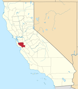 | |
| CDPs | ||
| Unincorporated communities | ||
| CCDs | ||
| Ghost towns | ||