Bunker Hill, Los Angeles
| Bunker Hill | |
|---|---|
| Neighborhood of Los Angeles | |
|
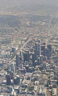
Bunker Hill as seen from Los Angeles City Hall | |
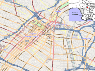 Bunker Hill Location within Downtown Los Angeles | |
| Coordinates: 34°03′07″N 118°15′01″W / 34.052035°N 118.250347°W | |
| Country | United States |
| State | California |
| County | County of Los Angeles |
| City | Los Angeles |
| Area code(s) | 213 |

Bunker Hill is a historic prominence that traditionally separated Downtown Los Angeles from the rest of the city to the west before the hill was tunneled through at Second Street in 1924.[1]
In the late 20th century, the hill was lowered in elevation, and the entire area was redeveloped to supplant old frame and concrete buildings with modern high-rises and other structures for residences, commerce, entertainment and education. The Cathedral of Our Lady of the Angels is also on Bunker Hill.
History

Early development
In 1867, a wealthy developer, Prudent Beaudry, purchased a majority of the hill's land. Because of the hill's excellent views of the Los Angeles Basin and the Los Angeles River, he knew that it would make for an opulent subdivision. He developed the peak of Bunker Hill with lavish two-story Victorian houses that became famous as homes for the upper-class residents of Los Angeles. Angels Flight, now dubbed "The World's Shortest Railway", took residents homeward from the bottom of the 33% grade and down again.
Initially a residential suburb, Bunker Hill retained its exclusive character through the end of World War I, but in the face of increased urban growth fed by an extensive streetcar system, its wealthy residents began leaving for enclaves on the Westside and Pasadena. Bunker Hill's houses were increasingly sub-divided to accommodate renters. Still, Bunker Hill was at this time "Los Angeles's most crowded and urban neighborhood".[2] By World War II the Pasadena Freeway, built to bring shoppers downtown, was taking more residents out. Additional post-war freeway construction left downtown comparatively empty of both people and services. The once-grand Victorian mansions of Bunker Hill became the home of impoverished pensioners.[3]
Bunker Hill Redevelopment Project
In 1955, Los Angeles city planners decided that Bunker Hill required a massive slum clearance project. The top of Bunker Hill was cleared of its houses and then flattened as the first stage of the Bunker Hill Redevelopment Project to populate Bunker Hill with modern plazas and buildings. When the height limit of buildings for Los Angeles was finally raised (previously buildings were limited to 150 feet), developers built some of the tallest skyscrapers in the region to take advantage of the area's existing dense zoning. In approving such projects, the city sought to project a modern, sophisticated image.
The project is the longest redevelopment project in Los Angeles history. The majority of the skyscrapers on Bunker Hill were built in the 1980s, with a new skyscraper or two being finished nearly every year. However, the momentum died down in the 1990s, shortly after the fifty-two story Two California Plaza was finished.[4] In 1999, the vacancy rate for downtown commercial skyscrapers was 26%, one of the highest in the nation for that time. Planned office towers were canceled, including California Plaza Three,[5] and the nearby four-towered Metropolis (brought back to life in 2005).
Bunker Hill today


Many of the older buildings and the early high-rises surrounding Bunker Hill are undergoing adaptive reuse from commercial to residential. This trend began in 2000, when the Los Angeles City Council passed an Adaptive Re-Use Ordinance, allowing old unused office buildings to be redeveloped as apartments or "lofts". Developers realized there was a high level of pent-up demand for living in or near downtown, by both artists and employees of various firms in the financial district and government workers in the Civic Center, and that they could profit by supplying housing to meet such demand.
Because of the popularity of the New Urbanism in California, the city has required developers to build mixed-use residential buildings as much as possible. This means that the first floor of such residential developments is devoted to commercial retailers, so that residents do not have to constantly drive around for all their shopping trips and buildings present a more welcoming facade to passersby on the sidewalk.
Contributing to the resurgence of Bunker Hill has been the construction of public venues, such as the Walt Disney Concert Hall and Cathedral of Our Lady of the Angels, and the Museum of Contemporary Art, as well as the Colburn School, a community performing arts school and collegiate conservatory. In February 2007 $2.05 billion was approved for the Grand Avenue Project, which over the next 10 years will bring in over 2,000 new residential units, over 400 of them being affordable units for all degrees of low-income families; 1 million square feet (93,000 m²) of office space; a Mandarin Oriental hotel; 600,000 square feet (56,000 m²) of retail and entertainment space; and the Grand Park, connecting City Hall to Bunker Hill. Office space and residential units will be in several skyscrapers ranging between 35-55 stories each. Nearby planned projects include L.A. Live on Figueroa Street and Olympic Boulevard in South Park (the southern end of the Bunker Hill area). A new major modern art museum, The Broad, opened on September 20, 2015, next to Disney Hall.[6]
The Angels Flight tramway, which was rebuilt in 1996 near where it was originally located and shut down after a fatal accident in 2001, reopened on March 15, 2010 to provide a link between Bunker Hill and the revitalized downtown area. One sign of the success of the downtown renaissance is that the office vacancy rate for the fourth quarter of 2004 was 16%, compared to 19% for 2003, and 26% for 1999.[7]
Mix of housing options
While developers are primarily building market-rate housing on Bunker Hill today, the City of Los Angeles has very strict laws, rules, and ordinances established that promote the inclusion of all income levels into the residential mix. Some examples include incentives for the creation of affordable housing (rather than market-rate housing), the preservation of existing affordable housing, the development of affordable housing by the city itself (rather than waiting for private developers), and others. The city has written documentation regarding the development of affordable housing.[8]
On the topic of building affordable housing for very low-income to moderate-income, Principal City Planner Jane Blumenfeld said, "We are trying to make it attractive to build [downtown] and get this added affordable housing that we normally wouldn't have. We need an adequate amount of lower income housing so that in 20 years Downtown doesn't become an exclusive neighborhood."[9]
The Emerson apartment building, owned by the Related Companies, has 271 units, of which 216 are leased at market rates. The other 55 units are at subsidized rates to tenants whose annual incomes are less than 50% of the local median, which was $42,700 for a family of four in 2014.[10]
Bunker Hill in popular culture

Radio
On "The Adventures of Philip Marlowe" radio program with episode named "Baton Sinister" dated September 17, 1949, Angels Flight is referenced as Marlowe has a rendezvous set in Bunker Hill.
Film
In the 1940s and 1950s, Bunker Hill was a popular film setting, especially in the film noir genre, because of its Victorian homes, its rambling hillside apartments and flophouses, its Angels Flight funicular, and its mean (or at least mean-looking) streets. [11][12] It was used extensively in such crime films as Cry Danger (1951), Kiss Me Deadly (1956), Criss Cross (1949), Joseph Losey's M (1951) and Angel's Flight (1965). Director Curtis Hansen recreated Bunker Hill in another hilly neighborhood altogether in his Oscar Award-winning L.A. Confidential (1997). [13][14][15] Kent Mackenzie made a film in 1956 called Bunker Hill which was about the displacement of the residents who had to make way for construction. [16][17][18] Another film by Mackenzie that was set in the area, his neo-realist and semi-documentary feature The Exiles (1961) depicts the lives of a tribe of urban Indians on Bunker Hill in the late 1950s. [19]
Angels Flight and its Third Street neighborhood, circa 1930s, were recreated in South Africa for the filming of Ask the Dust (2006), based on the novel by John Fante, which was set in the district in the 1930s. Fante also wrote a book called Dreams From Bunker Hill, his last novel, dictated near death to his wife.
The 2nd Street Tunnel under Bunker Hill is widely used in film and advertising.
Music
Bunker Hill is also the title of (and referenced in) the 1992 song from the Free-For-All album by Angelino transplant Michael Penn and a B-Side-song of the band Red Hot Chili Peppers. Jim Dawson's 2008 book Angels Flight includes several chapters, complete with many dozens of early photos, on Bunker Hill and its literary and film background.
Other media
It is represented in the 2013 video game Grand Theft Auto V as "Pillbox Hill" ("Pillbox" and "Bunker" being similar) in the game's rendition of Los Angeles as Los Santos.
Fire service

Los Angeles Fire Department operates fire Station 3 (Civic Center/Bunker Hill) in the area.
Education
The area is served by the Los Angeles USD.
Notable residents
- Richard Crenna, actor
- John Fante, American novelist
- Jack Webb, actor, producer, creator of Dragnet and 1 Adam 12
- Otto J. Zahn, Los Angeles City Council member in the 1920s and pigeon racer
References
- ↑ 2012-2013 Official Visitors Map, Los Angeles Tourism & Convention Board, 2012
- ↑ Mike Davis, "Hollywood's Dark Shadow," in Dead Cities and Other Tales (New York: The New Press, 2003; orig. ed. 2002), 132.
- ↑ Documentary "Bunker Hill" special feature on the DVD The Exiles
- ↑ Stevenson, Richard W. (November 11, 1991), "Office Glut Spreads in California", New York Times
- ↑ Berton, Brad (April 26, 1993), "Los Angeles Community Redevelopment Agency's notice of default suit against Bunker Hill Associates", Los Angeles Business Journal
- ↑ http://www.latimes.com/entertainment/arts/la-et-cm-broad-opening-day-20150921-story.html
- ↑ Vincent, Roger (13 February 2014) "With sale of Two California Plaza, Bunker Hill is poised for comeback" Los Angeles Times
- ↑ http://www.lacity.org/lahd/curriculum/index.html Archived February 16, 2005, at the Wayback Machine. lacity.org
- ↑ http://www.downtownnews.com/articles/2005/03/28/news/news02.txt downtownnews.com
- ↑ Vincent, Roger (October 1, 2014) "Developer of new Bunker Hill apartment high-rise woos older residents" Los Angeles Times
- ↑ LA Downtown News Will Angels Flight Ever Roll Again?
- ↑ tumblr. Los Angeles's Bunker Hill: Pulp Fiction's Mean Streets and Film Noir's Ground Zero!
- ↑ Electric Earl Bunker Hill Goies to the Movies
- ↑ Pitzer College From Berlin to Bunker Hill: Urban Space, Late Modernity, and Film Noir in Fritz Lang's and Joseph Losey's M Edward Dimendberg Archived March 3, 2016, at the Wayback Machine.
- ↑ Time Friday, July 18, 2008 Exiles on Indie Street By Richard Corliss
- ↑ LA Observed July 31, 2010 Weekend viewing: Bunker Hill, 1956 by Kevin Roderick
- ↑ LA Observed August 3, 2010 Bunker Hill video deleted from Vimeo * By Kevin Roderick
- ↑ Los Angeles Film Forum This is the City
- ↑ Oscilloscope [http://www.oscilloscope.net/films/film/36/The-Exiles The Exiles
 |
Echo Park, Los Angeles | Civic Center, Los Angeles |
| ||||
| |
|||||||
| Westlake, Los Angeles | |
||||||
| |
|||||||
| Financial District, Los Angeles | Historic Core, Los Angeles |
| Districts and neighborhoods | _edit1.jpg) | |
|---|---|---|
| Points of interest | ||
Coordinates: 34°03′07″N 118°15′01″W / 34.052045°N 118.250347°W