Bungle Bungle Range
Bungle Bungle Range is the landform that is the major component of the Purnululu National Park in Western Australia.
Formation
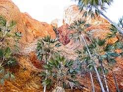
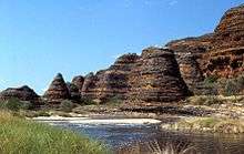
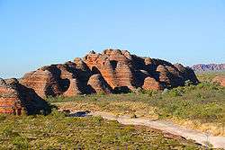
The distinctive beehive-shaped towers are made up of sandstones and conglomerates (rocks composed mainly of pebbles and boulders and cemented together by finer material). These sedimentary formations were deposited into the Red Basin 375 to 350 million years ago, when active faults were altering the landscape. The combined effects of wind from the Tanami Desert and rainfall over millions of years shaped the domes. Weathering also helped create this marvel. Water seeps into the rock, and at night it expands as it gets colder. This creates small cracks which eventually wears out the rock.

Description
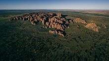
A 7km diameter circular topographic feature is clearly visible on satellite images of the Bungle Bungle Range (Google Maps image). It is believed that this feature is the eroded remnant of a very ancient meteorite impact crater and is known as the Piccadilly impact structure.
The unusual orange and dark grey banding on the conical rock formations is caused by differences in the layers of sandstone. The darker bands are on the layers of rock which hold more moisture, and are a dark algal growth. The orange colored layers are stained with iron and manganese mineral deposits.
The Bungle Bungle Range formation occupies an area of approximately 450 square kilometres (174 sq mi).[1]
History
The traditional owners of the area are the Karjaganujaru peoples.[2]
Aboriginal people have been living in the area for over 20,000 years and continue to maintain a strong connection to this ancient landscape. The national park is managed by the Western Australian Department of Environment and Conservation in conjunction with the traditional Aboriginal owners.[3]
The range remained largely unknown except by local Aborigines and stockmen until 1982 when film-makers arrived and produced a documentary about the Kimberley. The area was gazetted as a National Park in 1987 and was also inscribed as a World Heritage area in 2003.[3]
See also
- Protected areas of Western Australia
- Kimberley region of Western Australia
- List of reduplicated Australian place names
References
- ↑ "Purnululu National Park" (PDF). Department of Environment. Retrieved 23 May 2015.
- ↑ Five Anthropologist Proven its Karjaganujaru peoples land, and the Bungle Bungle head office has said its jaru people land
- 1 2 "History and Geology". Kimberley Australia Guide. Retrieved 23 May 2015.
External links
| Wikimedia Commons has media related to Purnululu National Park. |
- Purnululu National Park
- Bungle Bungle Range (Purnululu National Park) "Information Site" including all relevant history, Photos and information about the local area...Kununurra, Halls Creek and surrounds
Coordinates: 17°25′17″S 128°26′42″E / 17.4214°S 128.4449°E