Buldhana district
| Buldhana district बुलढाणा जिल्हा | |
|---|---|
| District of Maharashtra | |
 Location of Buldhana district in Maharashtra | |
| Country | India |
| State | Maharashtra |
| Administrative division | Amravati Division |
| Headquarters | Buldhana |
| Tehsils | Buldhana, Chikhli, Deulgaon Raja, Khamgaon, Shegaon, Malkapur, Motala, Nandura, Mehkar, Lonar, Sindkhed Raja, Jalgaon Jamod, Sangrampur |
| Government | |
| • Lok Sabha constituencies | Buldhana (MH-5), Raver (MH-4)( shared with Jalgaon district)[1] |
| • Assembly seats | Malkapur, Buldhana, Chikhli, Sindkhed Raja, Mehkar, Khamgaon, Jalgaon Jamod |
| Area | |
| • Total | 9,640 km2 (3,720 sq mi) |
| Population (2011) | |
| • Total | 2,588,039 |
| • Density | 270/km2 (700/sq mi) |
| • Urban | 21.2 |
| Demographics | |
| • Literacy | 82.09% |
| • Sex ratio | 928 |
| Major highways | NH-6 |
| Average annual precipitation | 946 mm |
| Website | Official website |
Buldhana district (Marathi: बुलढाणा जिल्हा) is a district in the Amravati division of Maharashtra state in western India. It is situated at the westernmost border of Vidarbha region of Maharashtra and is 500 km from the state capital, Mumbai. It is bounded by Madhya Pradesh on the north, Akola, Washim, and Amravati districts on the east, Jalna district on the south, and Jalgaon and Aurangabad districts on the west. Buldhana is religiously important as the site of the Shri Gajanan Maharaj temple, at Shegaon.[2]
Origin of name
The name of the district is derived probably from Bhil Thana (place of Bhils, a tribal group).[3]
History
Buldhana, along with the rest of Berar Province, was part of the kingdom of Vidarbha mentioned in the Mahabharata, a Sanskrit epic poem. Berar formed part of the Maurya Empire during the reign of Ashoka (272–231 BCE). Berar came under the rule of the Satavahana dynasty (2nd century BCE–2nd century CE), the Vakataka dynasty (3rd to 6th centuries), the Chalukya dynasty (6th to 8th centuries), the Rashtrakuta Dynasty (8th to 10th centuries), the Chalukyas again (10th to 12th centuries), and finally the Yadava dynasty of Devagiri (late 12th to early 14th centuries). A period of Muslim rule began when Alauddin Khilji, Sultan of Delhi, conquered the region in the early 14th century. The region was part of the Bahmani Sultanate, which broke away from the Delhi Sultanate in the mid-14th century. The Bahmani Sultanate broke up into smaller sultanates at the end of the 15th century, and in 1572 Berar became part of the Nizam Shahi sultanate, based at Ahmednagar. The Nizam Shahis ceded Berar to the Mughal Empire in 1595. As Mughal rule started to unravel at the start of the 18th century, Asaf Jah I, Nizam of Hyderabad, seized the southern provinces of the empire (including Berar) in 1724, forming an independent state.

In 1853, the district, together with the rest of Berar, came under the administration of the British East India Company. Berar was divided into East and West Berar with Buldhana district being included in West Berar. In 1903, Berar was leased by the Nizam of Hyderabad to the British Government of India.
Some historical events
- 1437: Nasir Khan Faruqi, ruler of Khandesh, invaded Berar. A battle was fought at Rohinkhed with Khalif Hasan Basri, governor of Daulatabad, for Aladdin Ahmad Shah II Bahmani. Khan-i-Jahan, governor of Berar, was besieged in Narnala Fort. Nasir Khan lost the battle.
- 1590: The second battle at Rohinkhed took place between Burhan Nizam Shah and Jamal Kahn Mahdavi of Ahmednagar.
- 1600s: Veer Mata Jijabai, the mother of Chhatrapati Shivaji (founder of the Maratha Empire) was born at Sindkhed Raja, at the Palace of Lakhuji Jadhav.
- 1724: The battle of Sakharkheda–Fathkhelda: Asaf Jah defeated Mubariz Khan, governor of Malwa representing the Mughal Empire, and becomes Nizam of Hyderabad.[4]
- 1761: Malkapur pays money to Raghunathrao Peshwa for exception.
- 1729: Gates erected in Malkapur town during the rule of Mali Khan
- 1769: Madhavrao I Peshwa with minister of Nizam encamped at Mehkar to punish Janoji Bhonsle.
- 1790: Dyers flee to Nandura from Pimpalgaon Raja due to depredations of Mahadaji Sindhia and Pendharis
- 1803: Raghuji Bhonsle and Daulat Rao Sindhia meet the British envoy near Malkapur
- 1841: Mongal Rao plants flags of Maratha Bhonsla on the walls of Jamod
- 1863: Great Indian Peninsula Railway line opened passing through Malkapur & Shegaon
- 1878: Gajanan Maharaj was found on a street in Shegaon.
- 1881: Municipal council established in Shegaon.
- 1906: Municipal council established in Malkapur.
- 1930: Municipal council established in Chikhli.
- 1931: Municipal council established in Nadura.
Demographics
Talukwise Religious Population Percentage [5]
| Taluka Name | Hindu | Muslim | Christian | Sikh | Buddhist | Jain | Other | Atheist |
|---|---|---|---|---|---|---|---|---|
| Jalgaon Jamod | 75.24 | 13.37 | 0.16 | 0.04 | 10.70 | 0.15 | 0.01 | 0.29 |
| Sangrampur | 75.02 | 11.93 | 0.05 | 0.19 | 12.5 | 0.007 | 0.09 | 0.18 |
| Shegaon | 69.63 | 13.08 | 0.09 | 0.02 | 16.80 | 0.24 | 0.01 | 0.09 |
| Nandura | 70.46 | 15.12 | 0.06 | 0.03 | 13.90 | 0.24 | 0.01 | 0.12 |
| Malkapur | 67.85 | 20.14 | 0.12 | 0.03 | 10.60 | 0.98 | 0.01 | 0.30 |
| Motala | 73.17 | 13.17 | 0.05 | 0.01 | 13.10 | 0.21 | 0.03 | 0.18 |
| Khamgaon | 65.92 | 16.50 | 0.17 | 0.17 | 16.40 | 0.71 | 0.005 | 0.10 |
| Mehkar | 75.00 | 09.15 | 0.10 | 0.05 | 15.00 | 0.45 | 0.008 | 0.20 |
| Chikhli | 70.82 | 13.53 | 0.15 | 0.01 | 15.00 | 0.37 | 0.01 | 0.10 |
| Buldhana | 68.91 | 16.99 | 0.26 | 0.05 | 13.10 | 0.59 | 0.02 | 0.09 |
| Deulgaon Raja | 73.33 | 10.54 | 0.19 | 0.06 | 14.70 | 1.04 | 0.007 | 0.16 |
| Sindkhed Raja | 74.65 | 7.94 | 0.12 | 0.04 | 16.80 | 0.22 | 0.02 | 0.22 |
| Lonar | 77.70 | 9.57 | 0.08 | 0.04 | 11.60 | 0.68 | 0.001 | 0.27 |

According to the 2011 census Buldhana district has a population of 2,588,039,[6] roughly equal to the nation of Kuwait[7] or the US state of Nevada.[8] This gives it a ranking of 159th in India (out of a total of 640).[6] The district has a population density of 268 inhabitants per square kilometre (690/sq mi) .[6] Its population growth rate over the decade 2001-2011 was 15.93%.[6] Buldana has a sex ratio of 928 females for every 1000 males,[6] and a literacy rate of 82.09%.[6]
Languages
Apart from the commonly used Marathi language, language used in the district includes Andh, an Indo-Aryan language spoken by 100,000 people.[9]
Geography

Lonar crater lake is located in Buldhana district. It is the second largest impact crater in basaltic rock in the world. It was formed 60,000 years ago by a meteor impact. The pH of the water is about 11 (extremely alkaline). Lonar Crater has very different flora and fauna in its vicinity.
The Dnyanganga Sanctuary is situated in the district. There is good forest area in the sanctuary.
The climate is tropical and people mostly wear cotton clothes.
Buldhana district boundaries
It is bounded by Madhya Pradesh on the north, Akola, Washim, and Amravati districts on the east, Jalna district on the south, and Jalgaon and Aurangabad districts on the west. The district boundary latitudes are 19.51° to 21.17° N and longitudes are 75.57° to 76.59° E.
The district boundary has been changed many times. In 1480, as part of Berar taraf (province) of Bahamani Sultanate, Chikhli and Mehkar were part of Mahur division and Malkapur, Jalgaon, and Khamgaon were part of Gawil. During Akbar's time (1542–1605), it was part of the Sarkars (administrative unit) of Narnala, Baitalwadi, and Mehkar. In 1634 the area became known as Payanghat Subah (Lowlands Province) while Chikli and Mehkar were part of Balaghat Subah (Highlands Province), but by 1636 Berar became part of a large province called Deccan. Around that time, Malkapur, Jalgaon, Badner Bholji Pimpalgaon Raja, Jepur and Rajur were important parganas (administrative units of the Delhi Sultanate.[10]
In 1853 the district came into existence as North Berar district with Buldhana as its headquarters. It along with South Berar district with Hingoli as its headquarters constituted Berar Province.[11] North Berar district included the present Amravati district, the northern half of Akola, and Buldhana. After the Indian Rebellion of 1857 Hingoli, along with the neighbouring countryside, was restored to the Nizam. Berar province was reconstituted into East Berar district with headquarters at Amaravati, and West Berar district with headquarters at Akola.[12] After 1857 Mehkar, Chikhli, and Malkapur were part of West Berar district. In 1864 these three talukas were made independent as South-West Berar district, which was renamed Mehkar district in 1865.
In 1867 Buldhana district came into existence, combining North Berar and Mehkar districts. After the amalgamation of Berar with the Central Provinces in 1903, Buldhana district became the district of Central Provinces and Berar. In August 1905 Khamgaon and Jalgaon tehsils from Akola district of Central Provinces and Berar were combined into Buldhana district.[11]
In 1950 it became part of Madhya Pradesh with Nagpur as its capital. In 1956, along with other Marathi-speaking regions of Vidarbha, it became part of Bombay State and part of Maharashtra State in 1960.
Buldhana district rivers
The district lies in the Tapi River and Godavari River basins. Purna River is a tributary of the Tapi River while the Penganga and Kadakpurna Rivers are tributaries of Godavari River.
Here are some of the rivers in Buldhana, with their tributaries.
- Purna River
- Vaan River
- Mann River
- Utawali River
- Nipani River
- Mas River
- Bordi River
- River Dnyanganga
- Vishwaganga River
- Nalganga River
- Painganga River
- Khadakpurna River
- Dhamana River
- koradi River
- Jamvani peth
Economy
Cotton, sorghum and other cereals, oil seeds, soybean, sunflower, and groundnuts are the predominant crops grown in the district.
Khamgaon and Malkapur are the major cotton trading towns in the district. The district has many minor and medium size irrigation projects. The important ones are Nalganga and Vaan. There are thirteen Agriculture Produce Market Committees-Main Market, one in each tehsil, and there are twenty sub-markets in the districts.[13]
The Indian Council for Agriculture research funded a farm science centre Krishi Vigyan Kendra, Jalgaon Jamod in the district in 1994.[14]
The district has major industrial areas at Khamgoan and Malkapur and has smaller industrial areas at Chikhli, Buldhana, Dasarkhed, Deoulgaonraja, Mehkar, Sangrampur, and Lonar.
Representation
The district contributes one seat to the Lok Sabha (Lower House), namely Buldhana (Lok Sabha constituency). Prataprao Ganpatrao Jadhav of Shiv Sena is the current Member of Parliament from Buldhana.
Balasaheb darade is the leading educated youngstar studied in USA and return to his homtown in buldhana and presently he is leading Buldhana district on development path.
The district has seven seats in the Maharashtra State legislature assembly: Buldhana, Chikhli, Sindhkhe Raja, Mehkar, Khamgaon, and Jalgoan Jamod. The seventh seat at Malkapur is part of Raver (Lok Sabha constituency) in Jalgaon district.
District organisation
Revenue subdivisions
The district has six revenue subdivisions headed by a Sub Divisional Officer (SDO): Buldhana, Mehkar, Khamgaon, Malkapur, Jalgaon-Jamod and Sindkhedraja
Revenue talukas
As of 2010, the district of Buldhana comprises thirteen talukas (tehsils): Buldhana, Chikhli, Deulgaon Raja, Malkapur, Motala, Nandura, Mehkar, Sindkhed Raja, Lonar, Khamgaon, Shegaon, Jalgaon Jamod, and Sangrampur.
Each taluka/tehsil is headed by Tahsildar and assisted by Naib-Tahsildhar, Revenue Inspector and Talathis. Some of the revenue circles are Dhad, Raipur, Mhsala, Padali, Buldhana rural, Buldhana city, Mera, Undri, Amdapur, Eklara, Hatni, Kolara, Khairao, Chikhli rural, Chikhli town, Bibi, Sultanpur, Titavi, Lonar rural, Lonar town, Jalamb, Matargaon, Pahurjira, Manasgaon, Shegaon rural, and Shegaon town.[15]
Agriculture
The district superintending agriculture officer comes under Divisional Joint Director of Amravati Division. There are three subdivisions at Buldhana, Khamgaon, and Mehkar with a taluka agriculture officer at each taluka.
There are multiple circles under each taluka. They are Dhad, Shelapur, Dhamangaon, Motala, Shelsur, Amdapur, Chikhli, Dharangaon, Malkapur, Janephal, Mehkar, Bibi, Lonar, Sakharkherda, Sindkhed Raja, Mera Khurd, Deulgaon Mahi, Deulgaon Raja, Ganeshpur, Pimpalgaon Raja (Khamgaon), Nandura, Shegaon, Jalgaon Jamod, Warwat Khanderao, and Sangrampur.[16]
Amenities
Hemadpanthi temples
Hemadpanthi temples are located at Mehkar-Sonati, Sindhkhed Raja (Nilkantheshwar), and Sakegaon on the Chikhli-Dhad road. Three Shiva temples are located in Dhotra (Nandai), a village on Deulgaon Raja-Chikhli road. Two Shiva temples are located in Kothali (Jaipur) near Motala and also a hemadpanthi mandir in warwand of lord shiva 10 km far from buldhana on khamgaon road.
Police
The district has five police subdivisions and twenty-nine police stations.[17]
Transport Office
One Deputy Regional Transport Office is located in Buldhana district at District Headquarters. It enforces the Motor Vehicle Act and issues vehicle registration numbers in the district with the code MH-28..
Electricity
There is no electrical generating station in the district, but there is a good electricity transmission and distribution network.
There are two 22O kV substations at Buldhana and Chikhli, with Akola-Chikhli 220 kV line, 132kV substations at Buldhana, Dusarbid, Khamgaon, Malkapur, Mehkar, Motala and Warwat Bakal. The 132 kV lines runs as Chikhli-Dusarbid, Buldhana Tap, Khamgaon-Malkapur, Khamgaon-Jalamb Relay, Khamgaon Tap, Chikhli-Mehkar, Mekhar-Malegaon (Washim), Warwat Bakal Tap. The 685 km long 400 kV Koradi-Bhusawal transmission line passes through the district at Warwat Bakal.[18]
The distribution comes under Amravati Zone and Buldhana Circle with Buldhana, Khamgaon, and Malkapur Divisions. Each subdivision caters to more nearby talukas and has 33KV distribution substations under them.[19]
Irrigation
The district comes under Buldhana Irrigation Project Circle along with Akola and Washim district. The circle comes under Vidarbha Irrigation Development Corporation, Nagpur. It has its Major Project division at Shegaon, Kadakpurna at Deulgaon Raja, Mun Project division at Khamgaon, and Minor Irrigation Division at Chikhli and Akola.[20]
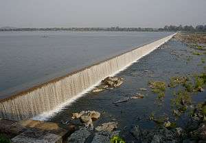
The completed irrigation projects are Nalganga Project in Motala and a major project in Vaan having one-fourth of the benefit accrue to Akola district. Many further irrigation projects are under way or are in the planning stages.[21]
Public Works Department
The district comes under Amravati Public Works Region and Akola Public Works Circle. It has one Public Works division at Buldhana with subdivision at Buldhana, Chikhli, Mehkar, and Deulgaon Raja; and a second, Khamgaon division, with subdivisions at Khamgaon, Jalgaon Jamod, and Malkapur; plus the Buldhana District Mechanical Subdivision.
There are Road Project subdivisions at Buldhana and Khamgaon under the Road Project Division of Akola. There is a separate Zilla Parishad Works Division at Buldhana with subdivisions at Buldhana, Kahmgaon, Mehkar, and Malkapur.[22] The department manages Government Rest houses at Buldhana, Khamgaon, Shegaon, Malkapur, Motala, Jalgaon Jamod, Sangrampur, Chikhli, Amdapur, Lavhala (Mehkar), Mehkar, Dongaon, Deulgaon Raja, Deulgaon Mahi, Sindkhed Raja, Lonar, and Nandura.[23]
Transport and travel
Motor bus, jeep, two-wheeler and railway are the popular modes of transport.
There are many Maharashtra State Road Transport Corporation bus stands in all towns of the district. There are State Transport bus depots at Buldhana, Malkapur, Chikhli, Mehkar, Khamgaon, Shegaon and Jalgaon-Jamod.
Railway
Electrified double-line broad-gauge railway passes through Malkapur, Nandura, and Shegaon Tehsils. It is under the Bhusawal-Badnera Section of Bhusawal Division of the Central Railway. This main line was originally under the Great Indian Peninsula Railway and the branch line between Jalamb and Khamgaon was under the Khamgaon State Railway.
The railway stations in the district, with their codes, are Khamkhed (KMKD), Malkapur (MKU), Wadoda (WDD), Biswa Bridge (BIS), Nandura (NN), Kumgaon Burti (KJL), Jalamb Junction (JM), Khamgaon (KMN), Shegaon (SEG), and Shrikshetra Nagzari (NGZ).
A computerised railway reservation facility is available at Buldhana,Malkapur and Shegaon, while manual reservation facility is available at City Booking Office, Khamgaon, Nandura, and Jalamb Junction.
Roads
National Highway
National Highway 6 - NH6 passes through Khamgaon, Nandura, and Malkapur towns in the district.
State highways

The following state highways connect various talukas and towns in the district. Vehicles from Nagpur, Amravati and Akola pass through Khamgaon–Chikhli–Deulgaonraja while going towards Jalna–Aurangabad and Pune.
The important roads in the district are:
- State Highway 24: Ajanta (Aurangabad) - Madh - Padli - Buldhana - Warwand - Khamgaon - Shegaon - Deori (Akola)
- 171 Lonar - Mehkar - Janephal - Pathardi - Deulgaon Sakarsha - Atali - Temburna NH 6
- MH State Highway 173: Tunki - Bawanbir - Warwat - Manasgaon - Shegaon - Khamgaon -Undri - Amdapur - Lavhala - Sakharkhera - Dusarbid - Raheri - Jalna district
- 176 Deulgaon Raja - Chikhli - Buldhana - Motala - Parda - Wakodi - Malkapur
- 177 Sindkhed Raja - Jalna district
- 183 Deulgaon Raja - Sindkhed Raja-Dusarbid- - Bibi - Sultanpur
- 188 Parda - Rohinkhed - Thad - Dhamnagaon Badhe - Jalgaon district
- 190 Wakodi - Jambhuldhaba - Gaulkhed
- 193 Buldhana - Dhad - Mahora (Jalna)
- MH State Highway 194: (Jalgaon) - Pimpalgaon Kale - Khandvi - Jalgaon Jamod - Sungaon - Jamod - Tunki -Sonala - Hiwarkhed (Akola)
- MH State Highway 195: Burhanpur - Jalgaon Jamod - Sangrampur - Warwat Bakal - Telhara (Akola)
- 196 Motala - Fuli - Tarwadi - Lonwadi- Nandura - Zadegaon - Khandvi
- 198 Balapur (Akola) - Jawala - Shegaon
- 199 Warwand - Undri - Chinchpur - Ambetakli - Adgaon - Wadegaon - Akola
- 205 Chikhli - Amdapur
- 206 Chikhli - Lovhala - Mehkar - Ukli - Sonati - Washim district
- 207 Mehkar - Dongaon - Malegaon (Washim)
Major district roads
- MDR 1 Tunki - Wasali - Ambabarva
- MDR 2 Kondari - Paturda - Kavthal - Bhendwal Bk - Khandvi
- MDR 7 Shegaon - Alasana - Kurkhed - Jalamb
- MDR 17 Shegaon - Zadegaon - Adsul - Padsul
- MDR 5 Jalamb - Matargaon - Bhendwal Bk - Niwana
Dist Near Town
- Warwand information
1) 10 km to Buldana -Kamgaon-Sheganon. Tempal Kameshwar in Shiva Eknath Maharaj Temple
Airport
The nearest airport is at Aurangabad which is 150 km from district headquarters.
Culture
There is a fair called Chaitra Masa Suklapaksha Navami at Shegaon on Rama Navami in Chaitra (March or April) each year.
Common folk arts are Bhajan (devotional singing), Kirtan (devotional chanting with musical instruments), and Gondhal (a complex art form involving ritual acts, dances, songs, and poems).
Residents of Buldhana are bilingual in Korku language, Hindi or Marathi language. Nihali language, a language isolate of India, is spoken by some 2,000 people (1991) in the Buldana district of Maharashtra.
Youth Hostel Buldhana is one of two youth hostels in Maharashtra and is located near Zilla Crida Sankulan with a 50-bed dormitory and five double rooms.
Places of interest

- Lonar, site of Lonar crater lake and Lonar Sanctuary
- Shri Shiddheshwar Bhagwan Sansthan, Kolara: 10 km from Chikhali on Mehakar Road, Place of Kalbhairav, also Visit Rambhau Maharaj Sansthan.

- Sindkhed Raja, birthplace of Veer Mata Jijabai, mother of Chhatrapati Shivaji and palace of Lakhuji Jadhav
- Temple of Shri Renuka Devi in Chikhli
- Balaji Temple, Vyankatgiri, Buldhana
- Budheshwar Temple, Madh, Buldhana (From this place river Painganga originates)
- Temple of Jagadamba Mata, Buldhana
- Balaji Temple in Mehkar
- Balaji Temple in Deulgaon Raja
- Dargah of Hazrath Sailani Baba in Sailani near Raipur
- Dargah Of Hazrat Shah Inayatullah Sabri(R.), Nandura
- Dargah of Hazrat Sufi Sar Mast Kalandar(R.), Nandura
- Panch Pandav temple Kawhala
- Shri Bapuji Maharaj in Malegaon Gond
- Dnyanganga Sanctuary
- Ambabarva Sanctuary
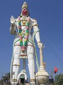
- The world's biggest Hanuman idol 105 feet in Nandura
- Palsi Supo Supoji Maharaj Temple
- Hanuman Mandir by Samarth Ramdas at Waghali, near Khamgaon
- Holy Buddha vihara garadgoan, near khamgaon

- Kondhana Jagdamba Utsav Mandal in Mutthe-Layout, Buldhana
- Parmanand Sarashwati maharaj Temple at Ran-antari Tq Chikhali ran-antri is near to ambashi
- Maruti temple at Ambashi .Tq.Chikhali.Dist.Buldana.
- Jagadamba Mata Temple Ambashi Tq.Chikhali Dist. Buldhana.

- Sant Gajanan Maharaj Temple,Shegaon Tq Shegaon
References
- ↑ (PDF) https://web.archive.org/web/20090306045236/http://164.100.9.199/ecimaps/ecipdf/state_pc_Map/Maharashtra.pdf. Archived from the original (PDF) on March 6, 2009. Retrieved October 26, 2009. Missing or empty
|title=(help) - ↑ "Shree's Samadhi Mandir". Shegaon, Maharashtra, India: Shri Gajanan Maharaj Sansthan. Archived from the original on 10 February 2015.
- ↑ Central Provinces Districts Gazetteers - Buldana District 1910.
- ↑ "Imperial Gazetteer of India, Vol. 9, p. 61". Digital South Asia Library. dsal.uchicago.edu.
- 1 2 "Population by religion community - 2011". Census of India, 2011. The Registrar General & Census Commissioner, India. Archived from the original on 25 August 2015.
- 1 2 3 4 5 6 "District Census 2011". Census2011.co.in. 2011. Retrieved 2011-09-30.
- ↑ US Directorate of Intelligence. "Country Comparison:Population". Retrieved 2011-10-01.
Kuwait 2,595,62
- ↑ "2010 Resident Population Data". U. S. Census Bureau. Archived from the original on 2010-01-01. Retrieved 2011-09-30.
Nevada, 2,700,551
- ↑ M. Paul Lewis, ed. (2010). "Andh: A language of India". Ethnologue: Languages of the World (16th ed.). Dallas, Texas: SIL International. Retrieved 2011-09-28.
- ↑ https://web.archive.org/web/20100526133506/http://www.maharashtra.gov.in/english/gazetteer/BULDHANA/rev_admin_land_record_dept.html. Archived from the original on May 26, 2010. Retrieved February 4, 2010. Missing or empty
|title=(help) - 1 2 https://web.archive.org/web/20080507175443/http://www.maharashtra.gov.in/english/gazetteer/BULDHANA/general_intro.html. Archived from the original on May 7, 2008. Retrieved May 9, 2008. Missing or empty
|title=(help) - ↑ https://web.archive.org/web/20101008134014/http://maharashtra.gov.in/english/gazetteer/AMRAVATI/his_modern%20period.html. Archived from the original on October 8, 2010. Retrieved February 4, 2010. Missing or empty
|title=(help) - ↑ https://web.archive.org/web/20071105140245/http://www.msamb.com/english/apmc/apmcs/buldhana.htm. Archived from the original on November 5, 2007. Retrieved February 1, 2007. Missing or empty
|title=(help) - ↑ https://web.archive.org/web/20100412133701/http://dare.nic.in/KVKList.htm. Archived from the original on April 12, 2010. Retrieved November 24, 2009. Missing or empty
|title=(help) - ↑ "बुलढाणा जिल्हा". Buldhana.nic.in. Retrieved 2016-02-27.
- ↑ https://web.archive.org/web/20080224203948/http://agri.mah.nic.in/agri/Asp/CircleOffice.asp. Archived from the original on February 24, 2008. Retrieved March 19, 2008. Missing or empty
|title=(help) - ↑ "Welcome to MPD, INDIA". Mahapolice.gov.in. Retrieved 2016-02-27.
- ↑ https://web.archive.org/web/20080310120632/http://www.mahatransco.in/transnw/ehv_substn_220.shtm. Archived from the original on March 10, 2008. Retrieved March 18, 2008. Missing or empty
|title=(help) - ↑ "Contact Your Nearest Office". Mahadiscom.in. 2007-10-08. Retrieved 2016-02-27.
- ↑
- ↑ https://web.archive.org/web/20050831051156/http://ceamt.vidcngp.com/cir/Bipc-4.htm. Archived from the original on August 31, 2005. Retrieved March 18, 2008. Missing or empty
|title=(help) - ↑ "Organisation Structure". Mahapwd.com. Retrieved 2016-02-27.
- ↑ "RestHouse". Mahapwd.com. Retrieved 2016-02-27.
External links
| Wikisource has the text of the 1911 Encyclopædia Britannica article Buldana. |
- Buldhana district website
- Buldhana district map
- Anuradha College of Engineering
- Lonar crater
- Jawahar navodaya vidyalaya, buldana at Shegaon
- Krishi Vigyan Kendra, Jalgaon Jamod
- Vivekanand Ashram, Hiwara Ashram, Tq. Mehakar.
 |
Jalgaon district | Burhanpur district, Madhya Pradesh | Amravati district | |
| Aurangabad | |
Akola district | ||
| ||||
| | ||||
| Jalna district | Hingoli district | Washim district |
| Subdivisions and tehsils | | |
|---|---|---|
| Cities, towns and villages | ||
| Railway stations |
| |
| Roads | ||
| Historical |
| |
| Geography | ||
| Lok Sabha constituencies | ||
| Vidhan Sabha constituencies |
| |
| Religious | ||
| People |
| |
| See Also |
| |
| Topics | |||||||||||||||||||||||
|---|---|---|---|---|---|---|---|---|---|---|---|---|---|---|---|---|---|---|---|---|---|---|---|
| Regions | |||||||||||||||||||||||
| Divisions and Districts |
| ||||||||||||||||||||||
| Million-plus cities in Maharashtra | |||||||||||||||||||||||
| Other cities with municipal corporations | |||||||||||||||||||||||
Portal: Maharashtra | |||||||||||||||||||||||
| Rivers |
|    | |||||||||||||||||||||||||
|---|---|---|---|---|---|---|---|---|---|---|---|---|---|---|---|---|---|---|---|---|---|---|---|---|---|---|---|
| Dams, barrages | |||||||||||||||||||||||||||
| Geographical features / regions | |||||||||||||||||||||||||||
| Riparian districts |
| ||||||||||||||||||||||||||
| Cities | |||||||||||||||||||||||||||
| Languages / people | |||||||||||||||||||||||||||
| Coalfields | |||||||||||||||||||||||||||
| Oil / gas fields | |||||||||||||||||||||||||||
| Industries |
| ||||||||||||||||||||||||||
| Transport | |||||||||||||||||||||||||||
| Related topics | |||||||||||||||||||||||||||
| Other basins | |||||||||||||||||||||||||||
Coordinates: 20°31′58″N 76°10′58″E / 20.53278°N 76.18278°E