Bulandet
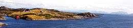 View of Bulandet | |
 Bulandet Location in Sogn og Fjordane county | |
| Geography | |
|---|---|
| Location | Sogn og Fjordane, Norway |
| Coordinates | 61°17′50″N 4°37′20″E / 61.2972°N 4.6221°ECoordinates: 61°17′50″N 4°37′20″E / 61.2972°N 4.6221°E |
| Total islands | 300 |
| Major islands | 15 |
| Highest elevation | 43 m (141 ft) |
| Administration | |
| County | Sogn og Fjordane |
| Municipality | Askvoll Municipality |
| Demographics | |
| Population | 260 |
Bulandet is an archipelago in the sea off the mainland coast of Western Norway. The island group is part of Askvoll Municipality in Sogn og Fjordane county, Norway. It sits about 20 kilometres (12 mi) west of the mainland coast of Askvoll. The islands of Værlandet and Alden lie immediately east of Bulandet. The Geita Lighthouse lies about 10 kilometres (6.2 mi) southeast of Bulandet.
Bulandet is Norway's westernmost fishing village with a fish packing plant that has freezing and cooling systems. Bulandet Chapel is located at Kjempeneset on one of the main islands. The islands are connected to nearby Værlandet island by a series of bridges and roads. There is a regular ferry stop at Værlandet, connecting all of these islands to the mainland village of Askvoll.[1]
During World War II, Bulandet was used as a port for sailings between Norway, Shetland, and Scotland. The settlement at Bulandet was ravaged by punitive German attacks.[1]
See also
References
- 1 2 Store norske leksikon. "Bulandet" (in Norwegian). Retrieved 2013-12-03.
External links
- NRK-Norwegian Broadcasting Corporation slideshow
- How to get there, community council site with English version