Bukittinggi
| Bukittinggi Fort De Kock | ||
|---|---|---|
| City | ||
| Other transcription(s) | ||
| • Jawi | بوکيت تيڠݢي | |
|
Clock tower and main square | ||
| ||
|
Motto: Saayun Salangkah (Minangkabau: Same turn, same step) | ||
 | ||
 Bukittinggi Location of Bukittinggi in Sumatra | ||
| Coordinates: 0°18′20″S 100°22′9″E / 0.30556°S 100.36917°ECoordinates: 0°18′20″S 100°22′9″E / 0.30556°S 100.36917°E | ||
| Country | Indonesia | |
| Province | West Sumatra | |
| Government | ||
| • Mayor | Muhammad Ramlan Nurmatias (2016-2021)[1][2] | |
| Area | ||
| • Total | 25.24 km2 (9.75 sq mi) | |
| Elevation | 930 m (3,050 ft) | |
| Population (2014) | ||
| • Total | 117,097 | |
| • Density | 4,600/km2 (12,000/sq mi) | |
| Time zone | WIB (UTC+7) | |
| Area code(s) | +62 752 | |
| Climate | Af | |
| Website | www.bukittinggikota.go.id | |


Bukittinggi (Indonesian: Kota Bukittinggi, Minangkabau: Bukiktinggi, Jawi: بوکيت تيڠݢي), is the second largest city in West Sumatra, Indonesia, with a population of over 117,000 people and an area of 25.24 km². It is in the Minangkabau Highlands, 90 km by road from the West Sumatran capital city of Padang. The whole area is directly adjacent to the Agam Regency, and is located at 0°18′20″S 100°22′9″E / 0.30556°S 100.36917°E, near the volcanoes Mount Singgalang (inactive) and Mount Marapi (still active). At 930 m above sea level, the city has a cool climate with temperatures between 16.1° to 24.9°C. The city is the birthplace of some of the founders of the Republic of Indonesia, such as Mohammad Hatta and Assaat.
Bukittinggi was formerly known as Fort de Kock and was once dubbed "Parijs van Sumatera". The city was the capital of Indonesia during the Emergency Government of the Republic of Indonesia (PDRI). Before it became the capital of PDRI, the city was a centre of government, both at the time of the Dutch East Indies and during the Japanese colonial period.
Bukittinggi is also known as a leading tourist city in West Sumatera. It is sister city with Seremban in Negeri Sembilan, Malaysia. The Jam Gadang, a clock tower located in the heart of the city, is a symbol for the city and a well-visited tourist spot.
History

The city has its origins in five villages that served as the basis for a marketplace.[3]
The city was known as Fort de Kock in colonial times in reference to the Dutch outpost established here in 1825 during the Padri War. The fort was founded by Captain Bauer at the top of Jirek hill and later named after the then Lieutenant Governor-General of the Dutch East Indies, Hendrik Merkus de Kock.[4] The first road connecting the region with the west coast was built between 1833 and 1841 via the Anai Gorge, easing troop movements, cutting the costs of transportation and providing an economic stimulus for the agricultural economy.[5] In 1856 a teacher-training college (Kweekschool) was founded in the city, the first in Sumatra, as part of a policy to provide education opportunities to the indigenous population.[6] A rail line connecting the city with Payakumbuh and Padang was constructed between 1891 and 1894.[7]
During the Japanese occupation of Indonesia in World War II, the city was the headquarters for the Japanese 25th Army, the force that occupied Sumatra. The headquarters was moved to the city in April 1943 from Singapore and remained until the Japanese surrender in August 1945.[8]

During the Indonesian National Revolution, the city was the headquarters for the Emergency Government of the Republic of Indonesia (PDRI) from 19 December 1948 to 13 July 1949. During the second 'Police Action' Dutch forces invaded and occupied the city on 22 December 1948, having earlier bombed it in preparation. The city was surrendered to Republican officials in December 1949 after the Dutch government recognised Indonesian sovereignty.[9]
The city was officially renamed Bukittinggi in 1949, replacing its colonial name. From 1950 until 1957, Bukittinggi was the capital city of a province called Central Sumatra, which encompassed West Sumatra, Riau and Jambi. In February 1958, during a revolt in Sumatra against the Indonesian government, rebels proclaimed the Revolutionary Government of the Republic of Indonesia (PRRI) in Bukittinggi. The Indonesian government had recaptured the town by May the same year.
A group of Muslim men had planned to bomb a cafe in the city frequented by foreign tourists in October 2007, but the plot was aborted due to the risk of killing Muslim individuals in the vicinity.[10] Since 2008 the city administration has banned Valentine's Day and New Year's celebrations as they consider them not in line with Minangkabau traditions or Islam that can lead to "immoral acts" such as young couples hugging and kissing.[11]
Administrative districts
Bukittinggi is divided into three districts (kecamatan), which are further divided into five villages (nagari) and 24 kelurahan. The districts are:
- Guguk Panjang
- Mandiangin Koto Selayan
- Aur Birugo Tigo Baleh
Transportation
Bukittinggi is connected to Padang by road. Up until early 1980s there was a railway service from Padang Panjang that used to serve the city. For inner-city transport, Bukittinggi employs a public transportation system known as Mersi (Merapi Singgalang) and IKABE that connect locations within the city. The city preserves the traditional horse-cart widely known in the area as Bendi, although the use is limited and more popular with tourists, both domestic and foreign.
Tourism
It is a city popular with tourists due to the climate and central location. Attractions within the city include:
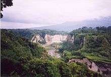

- Ngarai Sianok (Sianok Canyon)
- Lubang Jepang (Japanese Caves) — a network of underground bunkers and tunnels built by the Japanese during World War II
- Jam Gadang — a large clock tower built by the Dutch in 1926.
- Pasar Atas and Pasar Bawah are traditional markets downtown.
- Taman Bundo Kanduang park. The park includes a replica Rumah Gadang (literally: big house) with the distinctive Minangkabau roof architecture) used as a museum of Minangkabau culture and a zoo. The Dutch hilltop outpost Fort de Kock is connected to the zoo by the Limpapeh Bridge pedestrian overpass.
- Museum Rumah Kelahiran Bung Hatta (Museum of Bung Hatta Birthplace), the house where Indonesian founding father Mohammad Hatta was born, now a museum.[12]
- Best way to see Bukittinggi is by motorbike, car or by foot (trekkings).[13]
Notable nearby destinations include Lake Maninjau,Lake Tarusan, Kamang Cave, Tarang Cave, and the Harau Valley.
Sister cities
References
- ↑ "KPU Bukittinggi Tetapkan Walikota dan Wakil Walikota Bukittinggi Terpilih periode 2016-2021" (in Indonesian). 22 December 2015.
- ↑ "Selamat Atas Pelantikan Walikota Dan Wakil Walikota Bukittinggi" (in Indonesian). 2016.
- ↑ Nas, Peter J. M. (2002). The Indonesian Town Revisited. LIT Verlag. ISBN 3-8258-6038-8.
- ↑ Domenig, Gaudenz; Nas, P; Schefold, Reimar (2004). Indonesian Houses. National University of Singapore Press. ISBN 9971-69-292-9.
- ↑ Colombijn, Freek (2005). "A Moving History of Middle Sumatra, 1600–1870". Modern Asian Studies. 39 (1): 1–38. doi:10.1017/S0026749X04001374.
- ↑ Aritonang, Jan S. (1994). Mission Schools in Batakland (Indonesia), 1861-1940. BRILL. ISBN 90-04-09967-0.
- ↑ Krishnamurti, Indra (9 December 2004). "History of Railways in Indonesia". Retrieved 3 October 2007.
- ↑ Kahin, Audrey (1974). "Some preliminary observations on West Sumatra during the revolution". Indonesia. 18 (Oct): 76–117. doi:10.2307/3350695. JSTOR 3350695.
- ↑ Kahin, Audrey (1999). Rebellion to Integration: West Sumatra and the Indonesian Polity. Amsterdam University Press. ISBN 90-5356-395-4.
- ↑ "S'porean admits terror plot". 21 January 2009. Retrieved 14 February 2009.
- ↑ Syofiardi Bachyul Jb (14 February 2008). "Valentine's celebrations banned in Bukittinggi". Retrieved 14 February 2009.
- ↑ "Museum Rumah Kelahiran Bung Hatta". Retrieved 21 March 2010.
- ↑ "Roni's Adventure Tours". Retrieved 22 February 2013.
- ↑ "Bukittinggi: Jabaran Rencana Kota Kembar" (in Indonesian). Bukittinggi Department. Archived from the original on March 24, 2012. Retrieved 10 July 2013.
External links
| Wikimedia Commons has media related to Bukittinggi. |
- Pemerintah Bukittinggi - Bukittinggi City Council (Indonesian)
 Bukittinggi travel guide from Wikivoyage