Buka Airport
| Buka Island Airport | |||||||||||
|---|---|---|---|---|---|---|---|---|---|---|---|
| IATA: BUA – ICAO: AYBK | |||||||||||
| Summary | |||||||||||
| Airport type | Public | ||||||||||
| Operator | Government | ||||||||||
| Serves | Buka Island, Papua New Guinea | ||||||||||
| Elevation AMSL | 11 ft / 3 m | ||||||||||
| Coordinates | 05°25′20″S 154°40′21″E / 5.42222°S 154.67250°E | ||||||||||
| Map | |||||||||||
 BUA Location of airport in Papua New Guinea | |||||||||||
| Runways | |||||||||||
| |||||||||||
Buka Airport (IATA: BUA, ICAO: AYBK) is an airport serving Buka Island in the Autonomous Region of Bougainville (also known as North Solomons) in Papua New Guinea.
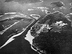
It is located at the southern end of the island, near Buka Passage behind the town of Buka, and pre-war Chinatown. The airport terminal is about 1.5 kilometres from the Buka Township.
In 2004, the airport experienced some closures due to land disputes. Residents of Ieta prevented service at the airport, demanding the government pay land fees.[3]
There is one navigational aid, the Buka NDB situated on nearby Sohano Island.
History
World War II
The origins of the airfield begin in 1941 when Australian troops built gun pits around a primitive airstrip in December 1941. On 2 January 1942 with the Japanese approaching, they prepared the airfield for demolition, blowing holes in the runway, and logs and pipes to prevent aircraft from landing. The following day, orders came to repair the field for aircraft evacuating from Rabaul to land. However, the airfield was occupied by the Japanese during mid-March 1942.
On 26 July, an Imperial Japanese Navy special detachment was sent to inspect Buka Airfield, but considered it unacceptable as a prospect for a speedily constructed major airfield. Nonetheless, by December 1942 the airfield was further improved by the Japanese with bitumen surfacing, an electrical power plant, underground fuel tanks, and new pillboxes and trenches. From December onwards many hulks were at the strip. Coastwatchers reported nighttime patrol flights during full moon. Also, scouting by a Betty Bomber flying down each coast of Bougainville and returning by afternoon as part of regular reconnaissance.
On 13 May 1943 Allied reconnaissance observed 36 fighters and 6 bombers at the airstrip. On 1 October 1943 Allied reconnaissance observed 35 aircraft at Buka, including 19 dive bombers. During 1943, the airfield was attacked repeatedly by Allied bombers, widely cratering the runway, and other areas.
In January 1944, the Allies drove the Japanese out of Buka, and the airfield was used for operations against the Japanese over New Guinea. A detachment of the USAAF 419th Night Fighter Squadron flew P-61 Black Widows from the airfield from 25 January – 27 May 1944 before moving forward into New Guinea.
Postwar
Today the airport is the primary air portal into Bougainville, and even 60 years after the war, wreckage from the military use of the airfield by the Japanese and Americans is easily found in the area.
Airlines and destinations
| Airlines | Destinations |
|---|---|
| Air Niugini | Lae, Port Moresby, Rabaul |
| Airlines PNG | Rabaul[4] |
See also
References
- ↑ Airport information for AYBK from DAFIF (effective October 2006)
- ↑ Airport information for BUA at Great Circle Mapper. Source: DAFIF (effective October 2006).
- ↑ "Land dispute in PNG affects airport at Buka". Radio New Zealand International. 14 September 2004.
- ↑ "Archived copy" (PDF). Archived from the original (PDF) on 2015-05-13. Retrieved 2015-04-11.
![]() This article incorporates public domain material from the Air Force Historical Research Agency website http://www.afhra.af.mil/.
This article incorporates public domain material from the Air Force Historical Research Agency website http://www.afhra.af.mil/.
- Maurer, Maurer (1983). Air Force Combat Units Of World War II. Maxwell AFB, Alabama: Office of Air Force History. ISBN 0-89201-092-4.
- Maurer, Maurer, ed. (1982) [1969]. Combat Squadrons of the Air Force, World War II (PDF) (reprint ed.). Washington, DC: Office of Air Force History. ISBN 0-405-12194-6. LCCN 70605402. OCLC 72556.
External links
| Airfields |
| .jpg) | |||||||||||||||||||||||||||||||||||||||
|---|---|---|---|---|---|---|---|---|---|---|---|---|---|---|---|---|---|---|---|---|---|---|---|---|---|---|---|---|---|---|---|---|---|---|---|---|---|---|---|---|---|
| Units |
| ||||||||||||||||||||||||||||||||||||||||