Bucyrus, Ohio
| Bucyrus, Ohio | |
|---|---|
| City | |
|
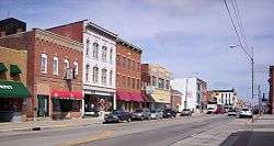
Downtown Bucyrus on South Sandusky Avenue | |
| Motto: "The Small City in the Middle of Everywhere" | |
 Location of Bucyrus, Ohio | |
 Location of Bucyrus in Crawford County | |
| Coordinates: 40°48′22″N 82°58′23″W / 40.80611°N 82.97306°WCoordinates: 40°48′22″N 82°58′23″W / 40.80611°N 82.97306°W | |
| Country | United States |
| State | Ohio |
| County | Crawford |
| Government | |
| • Mayor | Jeff Reser |
| Area[1] | |
| • Total | 7.43 sq mi (19.24 km2) |
| • Land | 7.42 sq mi (19.22 km2) |
| • Water | 0.01 sq mi (0.03 km2) |
| Elevation[2] | 994 ft (303 m) |
| Population (2010)[3] | |
| • Total | 12,362 |
| • Estimate (2012[4]) | 12,092 |
| • Density | 1,666.0/sq mi (643.2/km2) |
| Time zone | Eastern (EST) (UTC-5) |
| • Summer (DST) | EDT (UTC-4) |
| ZIP code | 44820 |
| Area code(s) | 419 |
| FIPS code | 39-10030[5] |
| GNIS feature ID | 1056736[2] |
| Website | City Website |
Bucyrus (/bjuːˈsaɪrəs/[6] byew-SY-russ) is a city in the U.S. state of Ohio and the county seat of Crawford County,[7] located in northern Ohio approximately 28 miles (45 km) west of Mansfield. The population was 12,362 at the 2010 census. The city is the largest in Crawford County, and the center of the Bucyrus Micropolitan Statistical Area (as defined by the United States Census Bureau in 2003).
History
The origin of the name Bucyrus is not certain. It was given by Col. James Kilbourne, who laid out the town in 1822.[8] One theory is that the name Bucyrus is derived from "beautiful" coupled with the name of Cyrus the Great, founder of the First Persian Empire.[9][10] An alternate theory is that the city was named after Busiris, a city of ancient Egypt.[10]
The Bucyrus Foundry and Manufacturing Company, a predecessor to Bucyrus International, Inc. was founded in Bucyrus in 1880. The company moved to Wisconsin in 1893.[11]
Bucyrus was once home to the Dostal Brothers Brewery. Founded in 1902, the brewery was run by John M. and George A. Dostal.[12][13]
The Lincoln Highway, later US Route 30, was routed through the city along Mansfield Street in 1913. In 1971 a modern, limited-access bypass was built to the north, but the associated freeway links to the east and west of Bucyrus, replacing the old two-lane Lincoln Highway route, were not completed until 2005, nearly 35 years after they were first proposed.
On March 10, 2007, Bucyrus was featured as the town of the week on the nationally syndicated Public Radio International program, Whad'Ya Know?.
Geography
Bucyrus is located at 40°48′22″N 82°58′23″W / 40.80611°N 82.97306°W (40.806014, -82.973169),[14] along the Sandusky River. According to the United States Census Bureau, the city has a total area of 7.43 square miles (19.24 km2), of which 7.42 square miles (19.22 km2) is land and 0.01 square miles (0.03 km2) is water.[1] Bucyrus is located 60 minutes north of Columbus, Ohio and 60 minutes south of Lake Erie.
Demographics
| Historical population | |||
|---|---|---|---|
| Census | Pop. | %± | |
| 1830 | 308 | — | |
| 1840 | 1,634 | 430.5% | |
| 1850 | 2,315 | 41.7% | |
| 1860 | 2,180 | −5.8% | |
| 1870 | 3,066 | 40.6% | |
| 1880 | 3,835 | 25.1% | |
| 1890 | 5,974 | 55.8% | |
| 1900 | 6,569 | 10.0% | |
| 1910 | 8,122 | 23.6% | |
| 1920 | 10,425 | 28.4% | |
| 1930 | 10,027 | −3.8% | |
| 1940 | 9,727 | −3.0% | |
| 1950 | 10,327 | 6.2% | |
| 1960 | 12,276 | 18.9% | |
| 1970 | 13,111 | 6.8% | |
| 1980 | 13,413 | 2.3% | |
| 1990 | 13,496 | 0.6% | |
| 2000 | 13,224 | −2.0% | |
| 2010 | 12,362 | −6.5% | |
| Est. 2015 | 11,916 | [15] | −3.6% |
| U.S. Decennial Census | |||
2010 census
As of the census[3] of 2010, there were 12,362 people, 5,320 households, and 3,219 families residing in the city. The population density was 1,666.0 inhabitants per square mile (643.2/km2). There were 5,983 housing units at an average density of 806.3 per square mile (311.3/km2). The racial makeup of the city was 96.3% White, 1.1% African American, 0.2% Native American, 0.7% Asian, 0.5% from other races, and 1.3% from two or more races. Hispanic or Latino of any race were 1.6% of the population.
There were 5,320 households of which 28.0% had children under the age of 18 living with them, 41.1% were married couples living together, 14.3% had a female householder with no husband present, 5.0% had a male householder with no wife present, and 39.5% were non-families. 34.3% of all households were made up of individuals and 15.1% had someone living alone who was 65 years of age or older. The average household size was 2.26 and the average family size was 2.85.
The median age in the city was 41.1 years. 22% of residents were under the age of 18; 7.8% were between the ages of 18 and 24; 24.5% were from 25 to 44; 27.3% were from 45 to 64; and 18.2% were 65 years of age or older. The gender makeup of the city was 47.8% male and 52.2% female.
2000 census
As of the census[5] of 2000, there were 13,224 people, 5,559 households, and 3,552 families residing in the city. The population density was 1,812.0 people per square mile (699.4/km²). There were 5,955 housing units at an average density of 816.0 per square mile (315.0/km²). The racial makeup of the city was 97.38% White, 0.78% African American, 0.27% Native American, 0.51% Asian, 0.02% Pacific Islander, 0.26% from other races, and 0.78% from two or more races. Hispanic or Latino of any race were 0.98% of the population.
There were 5,559 households out of which 29.6% had children under the age of 18 living with them, 46.6% were married couples living together, 13.0% had a female householder with no husband present, and 36.1% were non-families. 30.9% of all households were made up of individuals and 12.8% had someone living alone who was 65 years of age or older. The average household size was 2.33 and the average family size was 2.90.
In the city the population was spread out with 24.3% under the age of 18, 8.8% from 18 to 24, 27.4% from 25 to 44, 23.4% from 45 to 64, and 16.1% who were 65 years of age or older. The median age was 38 years. For every 100 females there were 89.9 males. For every 100 females age 18 and over, there were 86.3 males.
The median income for a household in the city was $32,394, and the median income for a family was $40,120. Males had a median income of $31,743 versus $20,795 for females. The per capita income for the city was $17,027. About 8.9% of families and 12.0% of the population were below the poverty line, including 15.6% of those under age 18 and 9.5% of those age 65 or over.
Business and industry
Industries located in Bucyrus include tapered roller bearings; highly engineered plow blades, wing shoes, and moldboard shoes; rubber hoses; and fluorescent lightings. Bucyrus is also the home of ESCO Bucyrus, and D. Picking and Company, a family operated manufacturer of copper kettles and timpani drums, employing the same techniques since its establishment in 1874 by its founder Daniel Picking.
Education
Most of Bucyrus is served by the Bucyrus City School District, which currently includes one elementary school (preschool through 5th grade), and one junior/senior high (6th through 12th). The western edges of the city limits are served by the Wynford Local School District located just west of the city, and the far eastern portion of the city is in the Colonel Crawford Local School District, headquartered in nearby North Robinson.
Bucyrus proper has no postsecondary educational institutions. Community colleges and regional four-year campuses of The Ohio State University serving Bucyrus commuters exist in nearby Mansfield and Marion, while two private universities in nearby Tiffin also enroll many Bucyrians.
Recreation
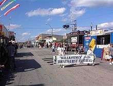
Bucyrus, which calls itself "the Bratwurst Capital of America", is home to the Bucyrus Bratwurst Festival,[16][17] held annually during the third weekend in August. It includes musical performances and a beauty pageant.
Notable Residents
- George Fenner - American soldier
- Judson Laipply - popular YouTuber
- Gloria LeRoy - American actress
- Harry L. Martin - Medal Of Honor recipient
- Paul Pfeifer - Ohio Supreme Court justice
- Cecil Souders - American football player
- Howard Wakefield - American baseball player
See also
References
- 1 2 "US Gazetteer files 2010". United States Census Bureau. Archived from the original on 2012-07-14. Retrieved 2013-01-06.
- 1 2 "US Board on Geographic Names". United States Geological Survey. 2007-10-25. Retrieved 2008-01-31.
- 1 2 "American FactFinder". United States Census Bureau. Retrieved 2013-01-06.
- ↑ "Population Estimates". United States Census Bureau. Archived from the original on 2013-06-17. Retrieved 2013-06-17.
- 1 2 "American FactFinder". United States Census Bureau. Archived from the original on 2013-09-11. Retrieved 2008-01-31.
- ↑ "A Pronunciation Guide to places in Ohio -- E.W.Scripps School of".
- ↑ "Find a County". National Association of Counties. Archived from the original on 2011-05-31. Retrieved 2011-06-07.
- ↑ Kilbourn, John (1833). The Ohio Gazetteer, or, a Topographical Dictionary. Scott and Wright. p. 109. Retrieved 12 December 2013.
- ↑ "Bucyrus: "Beautiful Cyrus"". Touring Ohio. Ohio City Productions Inc. Retrieved 2016-10-31.
- 1 2 Alfred, Maud Bush (1922). A Vision Fulfilled. Ohio Archæological and Historical Quarterly. The Ohio State Archæological and Historical Society. p. 17. Retrieved 27 October 2016.
- ↑ Bucyrus Timeline
- ↑ "Dostal Brothers Brewery – OH 21e". Old Breweries. Retrieved 2016-10-31.
- ↑ Internet Archive, pages 683-684.
- ↑ "US Gazetteer files: 2010, 2000, and 1990". United States Census Bureau. 2011-02-12. Retrieved 2011-04-23.
- ↑ "Annual Estimates of the Resident Population for Incorporated Places: April 1, 2010 to July 1, 2015". Retrieved July 2, 2016.
- ↑ Fenton, Laura (August 19, 2005). "What!? I can get this stuff for how much?". Today at msnbc. Retrieved 2009-10-28.
- ↑ Williams, Brian Jennings (September 11, 1981). "Brats Link Sheboygan, Bucycrus". The Milwaukee Sentinel. Retrieved 2009-10-28.
External links
| Wikisource has the text of the 1911 Encyclopædia Britannica article Bucyrus. |
- City of Bucyrus
- Discover Bucyrus
-
 Bucyrus travel guide from Wikivoyage
Municipalities and communities of Crawford County, Ohio, United States | ||
|---|---|---|
| Cities | 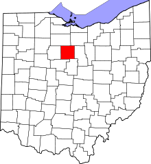 | |
| Villages | ||
| Townships | ||
| CDPs | ||
| Unincorporated communities | ||
| Footnotes | ‡This populated place also has portions in an adjacent county or counties | |