Buckner, Missouri
| Buckner, Missouri | |
|---|---|
| City | |
| Nickname(s): "The Little Village in the Valley" | |
 Location of Buckner, Missouri | |
| Coordinates: 39°8′5″N 94°11′54″W / 39.13472°N 94.19833°WCoordinates: 39°8′5″N 94°11′54″W / 39.13472°N 94.19833°W | |
| Country | United States |
| State | Missouri |
| County | Jackson |
| Area[1] | |
| • Total | 1.79 sq mi (4.64 km2) |
| • Land | 1.79 sq mi (4.64 km2) |
| • Water | 0 sq mi (0 km2) |
| Elevation | 751 ft (229 m) |
| Population (2010)[2] | |
| • Total | 3,076 |
| • Estimate (2012[3]) | 3,072 |
| • Density | 1,718.4/sq mi (663.5/km2) |
| Time zone | Central (CST) (UTC-6) |
| • Summer (DST) | CDT (UTC-5) |
| ZIP code | 64016 |
| Area code(s) | 816 |
| FIPS code | 29-09424[4] |
| GNIS feature ID | 0735540[5] |
Buckner is a city in Jackson County, Missouri, United States. The population was 3,076 at the 2010 census. For decades it was best known for TV and radio commercials promoting Lasater Ford, run by the Lasater brothers, Wilson and Milton.
Geography
Buckner is located at 39°8′5″N 94°11′54″W / 39.13472°N 94.19833°W (39.134806, -94.198223).[6] According to the United States Census Bureau, the city has a total area of 1.79 square miles (4.64 km2), all of it land.[1]
Demographics
| Historical population | |||
|---|---|---|---|
| Census | Pop. | %± | |
| 1880 | 88 | — | |
| 1890 | 164 | 86.4% | |
| 1900 | 234 | 42.7% | |
| 1910 | 410 | 75.2% | |
| 1920 | 439 | 7.1% | |
| 1930 | 529 | 20.5% | |
| 1940 | 571 | 7.9% | |
| 1950 | 639 | 11.9% | |
| 1960 | 1,198 | 87.5% | |
| 1970 | 1,695 | 41.5% | |
| 1980 | 2,848 | 68.0% | |
| 1990 | 2,873 | 0.9% | |
| 2000 | 2,725 | −5.2% | |
| 2010 | 3,076 | 12.9% | |
| Est. 2015 | 3,067 | [7] | −0.3% |
2010 census
As of the census[2] of 2010, there were 3,076 people, 1,141 households, and 808 families residing in the city. The population density was 1,718.4 inhabitants per square mile (663.5/km2). There were 1,243 housing units at an average density of 694.4 per square mile (268.1/km2). The racial makeup of the city was 95.6% White, 0.4% African American, 0.4% Native American, 0.1% Asian, 0.2% Pacific Islander, 1.2% from other races, and 2.2% from two or more races. Hispanic or Latino of any race were 3.4% of the population.
There were 1,141 households of which 41.0% had children under the age of 18 living with them, 50.7% were married couples living together, 13.1% had a female householder with no husband present, 6.9% had a male householder with no wife present, and 29.2% were non-families. 24.2% of all households were made up of individuals and 10.2% had someone living alone who was 65 years of age or older. The average household size was 2.70 and the average family size was 3.19.
The median age in the city was 33.6 years. 29.5% of residents were under the age of 18; 8% were between the ages of 18 and 24; 28.1% were from 25 to 44; 24.1% were from 45 to 64; and 10.4% were 65 years of age or older. The gender makeup of the city was 50.3% male and 49.7% female.
2000 census
As of the census[4] of 2000, there were 2,725 people, 1,019 households, and 747 families residing in the city. The population density was 1,595.3 people per square mile (615.3/km²). There were 1,065 housing units at an average density of 623.5 per square mile (240.5/km²). The racial makeup of the city was 95.93% White, 0.11% African American, 0.44% Native American, 0.26% Pacific Islander, 0.84% from other races, and 2.42% from two or more races. Hispanic or Latino of any race were 1.98% of the population.
There were 1,019 households out of which 39.1% had children under the age of 18 living with them, 54.0% were married couples living together, 13.7% had a female householder with no husband present, and 26.6% were non-families. 22.2% of all households were made up of individuals and 10.4% had someone living alone who was 65 years of age or older. The average household size was 2.67 and the average family size was 3.14.
In the city the population was spread out with 30.3% under the age of 18, 9.1% from 18 to 24, 29.6% from 25 to 44, 21.0% from 45 to 64, and 10.1% who were 65 years of age or older. The median age was 33 years. For every 100 females there were 96.9 males. For every 100 females age 18 and over, there were 91.5 males.
The median income for a household in the city was $40,577, and the median income for a family was $45,313. Males had a median income of $36,010 versus $22,372 for females. The per capita income for the city was $16,748. About 7.3% of families and 8.4% of the population were below the poverty line, including 10.4% of those under age 18 and 10.4% of those age 65 or over.
History
Buckner was established in 1875. In its inception Buckner was a railroad depot town for the Missouri Pacific Railroad. Where Buckner derives its name from is a point of contention; the town is either named from former US Senator Alexander Buckner (1830-1833) who served on the States Constitutional Convention in 1820, or named after Real Estate operator Simon Buckner. [9][10] Yet another claim as namesake is Thomas W. Buckner, an original owner of the site.[11]
The WGN America series Outlaw Country is set in Buckner.[12]
Infrastructure
Schools
Buckner resides in Fort Osage School District. The only school within the city limits is Buckner Elementary, for middle school children attend Fire Prairie Middle School, and move onto Fort Osage High School to complete their secondary education.
Churches
Buckner has several churches in its city limits. First Baptist Church (which attends the needs of the resident Baptists), Buckner United Methodist (a historical Methodist church constructed in the earily 1900's), two LDS affiliated churches Community of Christ Church and Israel's Gathering, Church of the Sante Fe parish (which attends the needs of the Catholic population), Living Waters Family Worship (a modernized non-traditional non-denominational church/community), and First Christian Church (a traditional non-demoninational church).
Libraries
Mid-Continent Public Library operates one general library branch in Buckner.
Media
Newspapers
The Gazette Weekly serves Buckner, Levasy, Sibley, and Eastern Independence on a weekly basis.
References
- 1 2 "US Gazetteer files 2010". United States Census Bureau. Archived from the original on 2012-07-14. Retrieved 2012-07-08.
- 1 2 "American FactFinder". United States Census Bureau. Retrieved 2012-07-08.
- ↑ "Population Estimates". United States Census Bureau. Archived from the original on 2013-06-17. Retrieved 2013-05-30.
- 1 2 "American FactFinder". United States Census Bureau. Archived from the original on 2013-09-11. Retrieved 2008-01-31.
- ↑ "US Board on Geographic Names". United States Geological Survey. 2007-10-25. Retrieved 2008-01-31.
- ↑ "US Gazetteer files: 2010, 2000, and 1990". United States Census Bureau. 2011-02-12. Retrieved 2011-04-23.
- ↑ "Annual Estimates of the Resident Population for Incorporated Places: April 1, 2010 to July 1, 2015". Retrieved July 2, 2016.
- ↑ "Census of Population and Housing". Census.gov. Archived from the original on May 11, 2015. Retrieved June 4, 2015.
- ↑ Eaton, David Wolfe (1916). How Missouri Counties, Towns and Streams Were Named. The State Historical Society of Missouri. p. 177.
- ↑ Earngey, Bill (1995). Missouri Roadsides: The Traveler's Companion. University of Missouri Press. p. 28.
- ↑ "Jackson County Place Names, 1928–1945 (archived)". The State Historical Society of Missouri. Archived from the original on 24 June 2016. Retrieved 13 October 2016.
- ↑ http://fox4kc.com/2015/02/24/large-crowd-flocks-to-premiere-of-new-buckner-based-wgn-show-outlaw-country/
External links
- City of Buckner (official site)
- Historic maps of Buckner in the Sanborn Maps of Missouri Collection at the University of Missouri
- Article in The History of Jackson county, Missouri (1881)
Municipalities and communities of Jackson County, Missouri, United States | ||
|---|---|---|
| Cities | 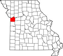 | |
| Villages | ||
| Townships | ||
| Unincorporated communities | ||
| Footnotes | ‡This populated place also has portions in an adjacent county or counties | |
Kansas City metropolitan area's cities and counties | ||
|---|---|---|
| Central city |  | |
| Largest cities (over 100,000 in 2000) | ||
| Medium-sized cities (10,000 to 100,000 in 2000) | ||
| Smaller Cities (between 5,000 and 9,900 in 2010) | ||
| Counties | ||