Buckden, Cambridgeshire
| Buckden | |
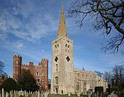 Great Tower and St.Mary's church |
|
 Buckden |
|
| Population | 2,805 (2011 census)[1] |
|---|---|
| OS grid reference | TL193661 |
| – London | 53 miles (85 km) |
| District | Huntingdonshire |
| Shire county | Cambridgeshire |
| Region | East |
| Country | England |
| Sovereign state | United Kingdom |
| Post town | St Neots |
| Postcode district | PE19 |
| Dialling code | 01480 |
| Police | Cambridgeshire |
| Fire | Cambridgeshire |
| Ambulance | East of England |
| EU Parliament | East of England |
| UK Parliament | Huntingdon |
|
|
Coordinates: 52°17′N 0°15′W / 52.28°N 0.25°W
Buckden is a village and civil parish 3.7 miles (6.0 km) north of St Neots and 4 miles (6.4 km) south-west of Huntingdon. Buckden is in Huntingdonshire which is a non-metropolitan district of Cambridgeshire as well as a historic county of England. The small hamlets of Stirtloe and Hardwick are also in the parish of Buckden. Buckden is situated close to three major transport networks. The River Great Ouse forms the eastern boundary of the parish; the Great North Road used to pass right through the centre of the village although today the village has a bypass just to the west; the East Coast Mainline runs along the eastern side of the Great Ouse river valley in the neighbouring parish of The Offords.
In the centre of Buckden is Buckden Palace which was a former residence of the bishops of Lincoln from the 12th century through to the early 19th century. A number of Kings of England have stayed at Buckden Palace and Catherine of Aragon was held there in 1533 before being moved to Kimbolton Castle in 1534.
Buckden prospered in the 18th and early 19th centuries because of its location just over 50 miles (80 km) north of London on the Great North Road, which was a busy coaching road at that time. The development of the railways in the mid-19th century led to a decline in the population of Buckden, but the village more than doubled in size in the second half of the 20th century.
History
Toponomy
Recorded in the Domesday Book as Bugedene,[2] Buckden has also been referred to as Buggeden (12th –13th century), Bokeden (13th –14th century), Bukeden (13th –14th century), and Bugden (15th –18th century),[3] with the present spelling entering usage in the 18th century. The name originates from the Old English; 'Bucge' is a person's name and 'dene' is the Old English word for valley.
Roman
Evidence of a Roman settlement was found in 1963–64 at quarry site to the east of Buckden village; in 1981, evidence of a Roman villa was found close to the Towers and a later excavation in 2006 at a site to the north east of Buckden village found evidence of a Romano-British field system from the first to fourth centuries AD.
Middle Ages
In 1961, archaeological excavations uncovered crucibles and fragments of crucibles that appear to have been used in the manufacture of white and yellow glass and which date back to Anglo-Saxon times. The site of the archaeology find was 0.5 miles (0.80 km) to the north east of Buckden village, in an area of the Great Ouse river valley that was about to be mined for sand and gravel.[4]
Buckden was listed in the Domesday Book in the Hundred of Toseland in Huntingdonshire; the name of the settlement was written as Bugedene in the Domesday Book.[5] In 1086 there was just one manor at Buckden; the annual rent paid to the lord of the manor in 1066 had been £20 and the rent had fallen to £16.5 in 1086.[6]
The Domesday Book does not explicitly detail the population of a place but it records that there was 58 households at Buckden.[6] This suggests a population of between 200 and 300. The survey records that there was 19 ploughlands at Buckden in 1086 and that there was the capacity for a further one ploughland.[6] In addition to the arable land, there were 84 acres (34 hectares) of meadows, 3,784 acres (1,531 hectares) of woodland and a water mill.[6] For the manor at Buckden the total tax assessed was 20 geld.[6]
By 1086 there was already a church and a priest at Buckden. In 1086 the land in Buckden was owned by the Bishop of Lincoln[2] and the Bishop of Lincoln may have had a house there even at that time. There was a certainly a house in Buckden where the bishop held court by the mid–12th century. In 1227 Henry III granted the right for the bishop of Lincoln to have a deer park at Buckden; by the time of a survey in 1647 the deer park covered 425 acres and had around 200 deer. At the end of the 17th century, the deer were gone and the land was enclosed in fields. The deer park was located to the west of the parish.[7]
Later there were two manors in Buckden; the larger manor was Buckden and the Members; the Lords of the manor were the bishops of Lincoln except for brief periods in the 14th, 16th and 17th centuries. The smaller manor was Buckden Brittains was the home of the Briton (or le Briton) family in the 13th century but afterwards changed hands a great many times.[8] By the early 19th century, about 1,200 acres (490 hectares) was owned by the manor of Buckden and the Members and about 225 acres (91 hectares) by the manor of Buckden Brittains.[7]
A number of kings of England stayed at Buckden Palace; Henry III stayed there in 1248, Edward I in 1291 and Richard III in 1483. Henry VIII sent Catherine of Aragon to reside in Buckden Palace after the annulment of their marriage (known as the King's Great Matter), from July 1533 to May 1534. Henry VIII and his fifth wife, Catherine Howard, stayed there in 1541.[9] On Friday 18 June 1641, "hundreds of women and boys, armed with Daggers and Javelins, in a very tumultuous and riotous Manner" entered part of the land at Buckden that belonged to the Bishop of Lincoln and they "turned in a great herd of cattle".[10]
Georgian
Buckden's location on the Great North Road meant that it was used as a coaching stop during the 18th century. There were four coaching inns in the village. The Lion dates back to the 15th century and was extended in the 18th century. The George Inn which had its own courtyard and forge was remodelled in the 18th century. The Vine dated back to the first half of the 17th century and was rebuilt in the 18th century when it included stables and its own brewery. The Spread Eagle originally built in the 17th century was altered in the 18th century; it had stabling and paddocks.[7] A schedule from 1839 showed that there were six express coaches heading north daily to Boston, Leeds, Lincoln, and York and as many heading south to London.[7] The presence of elegant Georgian houses on Church Street and the High Street (formerly the Great North Road) reflects the prosperity that was brought to Buckden by its strategic position on the coaching route north from London.
Victorian and modern
In 1854, just 15 years later, Buckden was described as 'a quiet insignificant place compared to what it was in coaching times'; the advent of the railways had quickly changed the fortunes of Buckden. The population, which had steadily increased from 869 in 1801 to a peak of 1,291 in 1841, then steadily decreased to 995 in 1911.[7]
The open fields in Buckden were enclosed by Act of Parliament in 1813. In 1842 a girls' school was opened (a school for boys had existed for over one hundred years) and a new school building was built in 1871. A post mill was built in Buckden in 1830 and was worked until 1888 when an auxiliary steam engine was installed; the mill was demolished in 1893. The Domesday Book mentions a water mill on the Great Ouse; the water mill was completely rebuilt c. 1850 and converted to steam power in the 1890s.[7]
The mill operated until the 1965; from then until the 1980s it was used for agricultural storage.[11] By 2015, the mill had been converted into apartments. In the second half of the 20th century, the building of new housing estates led to a substantial increase in the population of Buckden.
Government
As a civil parish, Buckden has its own elected parish council responsible for providing and maintaining a variety of local services.[12] A committee of the parish council reviews all planning applications and makes recommendations to Huntingdonshire District Council, which is the planning authority for the parish. The parish council also represents the views of the parish on issues such as local transport, policing and the environment.[12] The parish council raises its own tax to pay for these services, known as the parish precept, which is collected as part of the Council Tax. In 2015, Buckden parish council had 14 members; meetings were held on the second Tuesday of every month in the Millennium Hall in Buckden.[12]
Buckden was in the historic and administrative county of Huntingdonshire until 1965. From 1965, the village was part of a new administrative county of Huntingdon and Peterborough. In 1974, following the Local Government Act 1972, Buckden became a part of Cambridgeshire.
The second tier of local government is Huntingdonshire District Council which is a non-metropolitan district of Cambridgeshire.[13] Buckden is represented on Huntingdonshire District Council by one councillor for the Buckden ward. The Buckden district ward consists of the civil parishes of Buckden, Diddington and Southoe and Midloe.
Buckden is represented on Cambridgeshire County Council by one councillor for the Buckden, Gransden and The Offords electoral division. It is in the parliamentary constituency of Huntingdon County and elects one Member of Parliament (MP), since 2015 by Jonathan Djanogly. For the European Parliament Buckden is part of the East of England constituency which elects seven MEPs using the d'Hondt method of party-list proportional representation.
Geography
Buckden
The village of Buckden is about 1.7 miles (2.7 km) to the west of the River Great Ouse. Between the Great Ouse and Buckden there are a number of disused, flooded gravel quarries. The village lies on sloping ground on the western edge of the Great Ouse river valley. Just to the west of Buckden is the A1 road which follows the route of the Great North Road; the A1 runs approximately from south to north through the parish. There is a roundabout at the southern edge of Buckden that provides access to the village from the A1. The western half of the parish is gently sloping ground with low hills.

Hardwick
The hamlet of Hardwick is now joined to the north-west of Buckden village but on the western side of the A1 road. There is a pedestrian subway under the A1 that connects Hardwick with Buckden.
Stirtloe
The hamlet of Stirtloe is situated to the south of Buckden and is now separated from the village itself by only 220 yards (200 m) of fields.
Geology
The village and parish lies on a bedrock of Oxford Clay Formation mudstone which is a blue-grey or olive coloured clay that was formed between 156 and 165 million years ago in the Jurassic Period.[14] The central area of the parish has river terrace deposits of sand and gravel from the Quaternary period formed up to three million years ago by rivers. On the eastern side of the parish there are superficial depoists of alluvium (clay, silt, sand and gravel) formed up to two million years ago in the Quaternary period. The land to the west of the parish is characterised as Oadby Member Diamicton, again from the Quaternary period, with rocks formed during Ice Age conditions by glaciers scouring the land within the last two million years.[14]
On the western side of the parish, the soil is classified as a lime-rich loamy and clayey soil with impeded drainage. The central part of the parish, where the village lies, has freely draining slightly acid loamy soil. On the eastern side of the parish, the soil is classified as freely draining and slightly acid but a base-rich loamy soil.[15] The main agricultural land use within the parish of Buckden is arable but with grassland particularly in the Great Ouse river valley.[15] The parish of Buckden lies between 39 feet (12 m) and 180 feet (55 m) above ordnance datum and the parish covers an area of 3,114 acres (1,260 hectares).
Location
 |
Brampton | | ||
| Grafham | |
Offord Cluny and Offord D'Arcy | ||
| ||||
| | ||||
| Diddington |
The southern boundary of the parish follows the line of Diddington Brook and the eastern boundary follows the River Great Ouse.
Climate
The climate in the United Kingdom is defined as a temperate oceanic climate, or Cfb on the Köppen climate classification system, a classification it shares with most of northwest Europe.[16] Eastern areas of the United Kingdom, such as East Anglia, are drier, cooler, less windy and also experience the greatest daily and seasonal temperature variations. Protected from the cool onshore coastal breezes further to the east of the region, Cambridgeshire is warm in summer, and cold and frosty in winter.
The nearest Met Office climate station to Buckden is at Monks Wood near Alconbury, which is 9 miles (14 km) north of Buckden. The average annual rainfall for the United Kingdom between 1981 and 2010 was 1,154 millimetres (45.4 in) but Cambridgeshire is one of the driest counties with around half of the national level. Regional weather forecasting and historical summaries are available from the UK Met Office.[17][18] Additional local weather stations report periodic figures to the internet such as Weather Underground, Inc.[19]
| Climate data for Monks Wood, elevation 41m, (1981–2010 averages) | |||||||||||||
|---|---|---|---|---|---|---|---|---|---|---|---|---|---|
| Month | Jan | Feb | Mar | Apr | May | Jun | Jul | Aug | Sep | Oct | Nov | Dec | Year |
| Average high °C (°F) | 7.2 (45) |
7.7 (45.9) |
10.7 (51.3) |
13.5 (56.3) |
16.8 (62.2) |
19.7 (67.5) |
22.4 (72.3) |
22.3 (72.1) |
19.2 (66.6) |
15.0 (59) |
10.3 (50.5) |
7.4 (45.3) |
14.4 (57.9) |
| Average low °C (°F) | 1.1 (34) |
0.8 (33.4) |
2.6 (36.7) |
3.8 (38.8) |
6.6 (43.9) |
9.7 (49.5) |
11.8 (53.2) |
11.7 (53.1) |
9.9 (49.8) |
7.0 (44.6) |
3.9 (39) |
1.9 (35.4) |
5.9 (42.6) |
| Average rainfall mm (inches) | 47.0 (1.85) |
35.0 (1.378) |
40.1 (1.579) |
47.0 (1.85) |
47.9 (1.886) |
54.1 (2.13) |
48.3 (1.902) |
51.7 (2.035) |
53.3 (2.098) |
60.2 (2.37) |
54.2 (2.134) |
47.1 (1.854) |
585.8 (23.063) |
| Mean monthly sunshine hours | 58.0 | 77.4 | 109.9 | 152.3 | 186.2 | 180.6 | 193.3 | 188.1 | 142.5 | 114.6 | 67.0 | 52.4 | 1,522.2 |
| Source: Met Office Monks Wood, Cambridgeshire | |||||||||||||
Demography
The usual resident population of the parish of Buckden in the 2011 census was 2,805 of whom 48.1% were male and 51.9% female;[1] the population density was 576.6 persons per square mile (223 per km2). There were 1,260 households; 28.0% of these households consisted of one person, 68.4% contained one family group and there were 3.6% of other household types. The census also showed that 27.7% of households had one or more dependent children under the age of 18, and 30.6% of households consisted of people who were all over the age of 65. The mean average number of people per household was 2.4 people.[20]
Of the usually resident population in 2011, 20.4% were under the age of 18, 55.4% were between 18 and 65, and 24.2% were over the age of 65.[21] The mean average age of residents in Buckden was 44.1 years and the median age was 47 years.[22]
In 2011, 70.2% of the residents of Buckden were between the ages of 16 and 74 and seen to be potentially economically active. Of the potentially economically active residents, 67.9% were involved in part-time, full-time or self-employment; 30.0% were in fact economically inactive (including retired, carers, long-term sick and disabled), and 2.0% were unemployed. The five major industry sectors of the economically active residents of Buckden appear in the table below:[23]
| Industry Sector |
Percentage |
|---|---|
| Wholesale and Retail (including repair of motor vehicles) | 13.1% |
| Human Health and Social Work | 10.2% |
| Public Administration, Defence and Social Security | 10.1% |
| Education | 8.9% |
| Construction | 8.8% |
In 2009, at a time when the median household income across the whole of Cambridgeshire was £32,500, the median household income in Buckden was £36,900.[24]
The Office for National Statistics has allocated the village of Buckden to the Lower Layer Super Output Area (LSOA) called "Huntingdonshire 017C". Huntingdonshire 017C was ranked 23,371 out of 32,844 LSOAs in England against the index of multiple deprivation in 2015. This indicates that Buckden is amongst the 30% least deprived neighbourhoods in England.[25] Much of the civil parish of Buckden (but excluding the village itself) is in the Lower Layer Super Output Area (LSOA) called "Huntingdonshire 017B", which in 2015, was ranked 29,569 out of 32,844 LSOAs in England against the index of multiple deprivation. This indicates that the rural part of Buckden parish is amongst the 10% least deprived neighbourhoods in England.[25]
When compared with the rest of England, Buckden is not very ethnically diverse. The 2011 census showed that 93% of the residents of the parish of Buckden were born in the United Kingdom, with 3% of residents coming from other European Union countries, and 4% coming from the rest of the world.[26] At the same time, 98.3% of people in Buckden described themselves as ethnic white, 0.8% as having mixed or multiple ethnic groups, and 0.6% as being Asian or British Asian, with the remainder in another ethnic group.[27] In that same census, 69.3% described themselves as Christian, 23.2% said they had no religious beliefs, 6.3% did not specify a religion, and 1.1% described themselves as belonging to another religion (i.e. Buddhist, Hindu, Jewish, Muslim, Sikh or other).[28]
Historical population
The population of the parish of Buckden that was recorded at the UK censuses between 1801 and 1901 ranged between 869 and 1,209. The population of Buckden almost doubled in the 1960s.
| Parish |
1911 |
1921 |
1931 |
1951 |
1961 |
1971 |
1991 |
2001 |
2011 |
|---|---|---|---|---|---|---|---|---|---|
| Buckden | 995 | 998 | 1,037 | 1,057 | 1,158 | 2,010 | 2,535 | 2,515 | 2,805 |
Census: Buckden 1801–1971[29] Census Population: Buckden 1951, 1971, 1991[30] Census Population: Buckden 2001–2011[1][31]
The population of the district ward of Buckden, which includes the two parishes of Diddington and of Southloe and Midloe, was 3,293 according to the 2011 UK census.[32]
Culture and community
In 1871, there were thirteen inns and public houses in Buckden,[7] but by 2015 only three remained – The George, The Vine and The Lion Hotel. The Spread Eagle, which closed in 2003, is now a private house. All four of the coaching inns are Grade II listed buildings. Buckden has a small number of shops including local supermarkets, a post office, a pharmacy and clothing shops. There are over 100 private businesses based in the village.
Buckden Marina, which was built in 1963,[33] is adjacent to the Great Ouse; originally it had berths for around 150 boats but now provides berths for 240 boats. The marina covers an area of 22 acres (8.9 hectares). In 2001, Lafarge Aggregates and the Buckden Marina Company were jointly awarded the Cooper–Heyman Cup by the Quarry Products Association for restoring a 70 acres (28 hectares) quarry in Buckden as a water-recreation complex and wildlife area.[34]
The first issue of the Buckden Roundabout, a community magazine, was delivered in September 1979 and it has been published monthly ever since. A charitable trust was set up in 1958 to manage the village hall and the adjacent recreation ground. The recreation ground covers approximately 12 acres (4.9 hectares) and has four tennis courts, a children's play area, cricket and football pitches, and a bowls green. There is a cricket club, football club and bowls club (founded in 1929). The village hall was substantially extended in the early 21st century and it is now also known as the Buckden Millennium Village Hall. There is a library at the village hall.[35]
Transport
Buckden, which is situated on the old Great North Road, was bypassed by the A1 in 1962. A roundabout connects the village with the bypass and B661 (Perry Road for nearby Grafham Water), and also provides access to a filling station. Accessible through the village are The Offords via the B1043. Brampton is reached by a grade-separated junction just north of the village on the A1. A long-planned improvement scheme for the A14 may see it diverted north of the village to run parallel with the A1. A part of the scheme, the development of a new southern bypass for Huntingdon, would require the construction of a new section of road in an east-west direction between the village of Buckden and Brampton. The scheme would also require the building of a new bridge over the river Great Ouse.[36] Subject to final approval from the Secretary of State for Transport, construction might begin in late 2016 and be completed in 2020.[37]
Buckden lent its name to two railway stations, but both were located outside of the parish of Buckden. Just to the north of the village, a railway line from Kettering to Huntingdon was built in 1866 and a station called Buckden was opened. Rail services were run between Kettering and Cambridge from 1882 until 1959, after which the railway was dismantled.[38] Another railway station was built in the neighbouring village of Offord Cluny on the Great Northern Main Line called Offord and Buckden station; this station opened in 1851, was substantially extended in 1898 but it was closed by 1959.[7] Today, the nearest railway station is 3.5 miles (5.6 km) away at Huntingdon; regular services run south to London and north to Peterborough and beyond.
On weekdays and Saturdays there is an hourly bus service between Huntingdon and St Neots that stops in Buckden. The Ouse Valley Way is a 150 miles (240 km) long footpath that follows the River Great Ouse from its source near Syresham in Northamptonshire to its mouth in The Wash near King's Lynn.
Landmarks
Buckden is the location of Buckden Towers (or Buckden Palace), one of the many former residences of the Bishop of Lincoln. In the Middle Ages the diocese of Lincoln extended almost to London, so Buckden lay somewhere near to the middle of the diocese. A house was built by the mid-12th century, where the bishop of Lincoln held court, but this was burnt down in 1291 and then re-built. Further re-building and extending of the palace took place in the 15th century, including the addition of the red brick tower[7] which is of the same design as Tattershall Castle in Lincolnshire,[39] although the tower at Buckden has only four storeys. Buckden Palace also accommodated Catherine of Aragon for a short time before she was moved to Kimbolton Castle. The palace was neglected in the first half of the 17th century. A survey in 1647 listed the building and features, which included a Great Chamber, a chapel, a brick tower, and a gatehouse; all were inclosed by a moat. The grounds contained at least four fishponds and there were about 200 deer in the deer park.[7]
Huntingdonshire was transferred from the diocese of Lincoln to the diocese of Ely in 1837, and Buckden Palace was also transferred. A number of parts of the palace were demolished during the 19th century, and many of the parts that remained were used by the local vicar and a school. In 1848, the palace was described as a "venerable structure".[40] The palace passed into private ownership in 1870 and was renamed Buckden Towers. The Victorian house that is currently on the site was built in 1872.
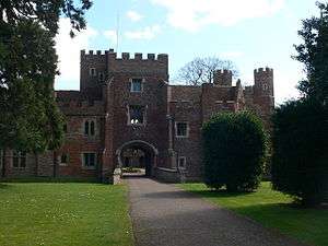
Between 1914 and 1919, Buckden Towers was used as a Red Cross hospital and during the Second World War as a home for evacuees from the London blitz. After the war, Buckden Towers was given to the Roman Catholic church and in 1956 the Towers went to the Claretian missionaries, who carried out some restoration work and built a Catholic church for the village.[41]
The site of the original Palace is designated an ancient monument and the Victorian Buckden Towers is a Grade II listed building; the Inner Gatehouse, the Curtain Wall and the Towers of the earlier Buckden Palace are all Grade I listed buildings. In addition to these and the former coaching inns, there are over 60 other listed buildings in the parish of Buckden, mainly located around Buckden Towers.[42] Much of the centre of the village around Buckden Towers, along the High Street and Church Street has been designated a Conservation Area by Huntingdonshire District Council.[39]
To the east of the village in the Great Ouse river valley there are a number of small lakes where gravel pits used to be worked. The enclosure map of 1813 shows the position of one gravel pit and another is shown on an Ordnance Survey map of 1926; but it was not until the 1960s that large-scale gravel and sand extraction took place. Sand and gravel were needed for two major local construction projects; the dual carriageway of the A1 road and the dam at Graham Water.[7] In 1986, the gravel pits at Buckden covered 400 acres (160 hectares).[43] Buckden Marina was constructed in a small disused gravel pit close to the Great Ouse.
Education
In 1661 a charity school was founded in Buckden for the education of boys in the parish and that school was still in existence when in 1842 a National School for girls was founded in part of the Bishop's Palace. A new school building was opened in 1871 to house the girls' school. The boys' and girls' schools merged in 1941.[7] A new infants school was opened in 1966, much of which was rebuilt after a fire in 1978, and a primary school was built in 1972.[7] The Buckden Church of England Primary School became an Academy in 2010 and operates independently of the local authority; 248 students were on the school roll in 2014–15.[44] The Ofsted report on the school following an inspection in 2015 rated the overall effectiveness of the school as outstanding.[44] Buckden is in the secondary education catchment area of Hinchingbrooke School.
Religious sites
The Anglican church, dedicated to St Mary the Virgin, is a grade I listed building. It consists of a chancel (with organ chamber and vestry), nave, west tower, north aisle, south aisle and porch. A church was listed in the Domesday book, but nothing from that date remains. The church contains some elements from the 13th century but it was greatly enlarged and re-built in the 15th century. The large buttresses to the north were added in the 17th century. The church was restored in 1840, 1860 and 1884. The west tower has an embattled parapet and is topped with an octagonal spire which Lewis described as "a tower surmounted by an elegant spire".[40] There were five bells in the bell tower[8] until 1997 when the bell frame and old bells were renewed, and an extra bell installed. A small extension known as the Living Stones Room was opened in 2011; it includes a meeting room, kitchen and toilets. In 2006, Buckden and the Offords were joined in a single benefice.[45] The church is in the deanery of St Neots, within the diocese of Ely.
A small Methodist chapel was built c. 1838 and a larger chapel built in 1876 remains in use today.[7] The Catholic church was built by the Claretians and dedicated to St Hugh of Lincoln in 1959; it is in the diocese of East Anglia.[41] A non-conformist chapel existed between c.1840 and 1862. Following its renovation, it re-opened in 1905 as a joint Baptist and Congregational chapel;[8] the chapel was in use as a religious site until 1984 when it was converted to a commercial use; in 2006 it was converted to a private residence.[7]
Notable people
- Hugh of Lincoln (c. 1135–1200), Bishop of Lincoln, builder of first wooden palace at Buckden.
- Robert Grosseteste (c. 1175–1253), scholastic philosopher, statesman and bishop of Lincoln, died at Buckden.
- Catherine of Aragon (1485–1536), divorced queen of Henry VIII, was confined at Buckden Towers in July 1533 – May 1534.[46]
- Thomas Barlow (1608/9–1691), religious writer and bishop of Lincoln, died at Buckden.[47]
- Thomas Pepys (1634–1664), a tailor and younger brother of Samuel Pepys, sold a house in Stirtloe, part of Buckden, in 1661/62.[48]
- Richard Reynolds (1674–1743), bishop of Lincoln active against the Walpole ministry in the House of Lords, was buried in Buckden church.[49]
- Edward Mann Langley (1851–1933), mathematician, was born in Buckden.
- John Leslie Green (1888–1916), born in Buckden, was awarded the Victoria Cross, for valour ending with his own death at the Battle of Loos on 1 July 1916.
- Lionel Powys-Maurice (1899–1991), a county cricketer with Northants, died in Buckden.
- Chris Morris (born 1962 in Buckden), is a comedian and director known for black humour.
Public services

Crime reported in Buckden December 2014 to November 2015[50]
Anglian Water supplies the village water and sewage services from their Huntingdon South Public Water Supply zone (FW41). The water quality was reported as excellent in 2015. In the same report, the hardness was reported as 301 mg/l of calcium carbonate which indicates that the water here is in the very hard range. The nearest reservoir, Grafham Water, is 1.5 miles (2.4 km) west of the village.
The Distribution Network Operator for electricity is UK Power Networks. There are three gas-fuelled power stations nearby; at Peterborough, Corby and at Little Barford near St Neots. The nearest, Little Barford Power Station, is 6 miles (9.7 km) from Buckden; it uses combined cycle gas turbines (CCGT) and is capable of generating 740 MW of electricity. There are two renewable-energy generation sites nearby. The landfill site at Station Farm on the Buckden Road uses landfill waste gas to generate a maximum of 1.9 MW of electricity. 3 miles (4.8 km) away at Cotton Farm near Graveley, onshore wind turbines generate a maximum of 20 MW of electricity.[51]
Huntingdonshire District Council is part of the Recycling in Cambridgeshire and Peterborough (RECAP) Partnership, which was granted Beacon status for waste and recycling in 2006–07.[52] In 2014–15, the council was just short of its target of recycling or composting 55% of all local household waste.
National Health Services (NHS) for the village are administered by NHS East of England. The nearest hospital is Hinchingbrooke, which is 4 miles (6.4 km) from Buckden and has a range of specialities, including Accident and Emergency. Further afield, there is Addenbrooke's Hospital, 16 miles (26 km) south-east and Papworth Hospital 4 miles (6.4 km) south-east of the village. The nearest doctor's surgery is in Buckden village.
The Cambridgeshire and Peterborough Fire Authority is responsible for providing fire and rescue services to a region that includes Buckden. Its headquarters are in Brampton; the nearest 24-hour fire station is at Huntingdon.
Cambridgeshire Constabulary is responsible for law enforcement within Cambridgeshire. The nearest police station to Buckden is at Huntingdon. In the 12 months from December 2014 to November 2015, there were 117 street crimes reported within a 1-mile (1.6 km) radius of Church Street, Buckden; this is an average of just under 10 crimes per month. The most frequent crime was anti-social behaviour. A Neighbourhood Watch Scheme has been operating in Buckden since before 1998.[53]
References
- 1 2 3 "Area: Buckden (Parish), Key Figures for 2011 Census". Neighbourhood Statistics. Office for National Statistics. Retrieved 29 December 2015.
- 1 2 Powell-Smith, Anna. "Open Domesday: Buckden". Open Domesday. Retrieved 29 December 2015.
- ↑ "Bugden". The Historical Gazetteer of England's Place Names. Retrieved 31 December 2015.
- ↑ Rye, Steven; Bayley, Justine. "Glass working crucibles from excavations at Buckden, Hunts 1961–64" (PDF). English Heritage. Retrieved 3 January 2016.
- ↑ Dr Ann Williams, Professor G.H. Martin, eds. (1992). Domesday Book: A Complete Translation. London: Penguin Books. p. 1321. ISBN 0-141-00523-8.
- 1 2 3 4 5 Professor J.J.N. Palmer, University of Hull. "Open Domesday: Place – Buckden". www.opendomesday.org. Anna Powell-Smith. Retrieved 25 February 2016.
- 1 2 3 4 5 6 7 8 9 10 11 12 13 14 15 "Buckden —A Huntingdonshire Village". Retrieved 31 December 2015.
- 1 2 3 Page, William; Proby, Granville; S Inskip, Ladds. "Parishes: Buckden in A History of the County of Huntingdonshire: Volume 2". British History Online. Victoria County History. Retrieved 31 December 2015.
- ↑ "The Palace of Buckden". Cambridge Military History. Retrieved 3 January 2016.
- ↑ "Order about the Bishop of Lincoln and his Tenants of Buckden.". House of Lords Journal. 1629–42. London. 4: 281–283. 22 June 1641. Retrieved 13 January 2016.
- ↑ "Offord and Buckden Mill". Domesday Reloaded. BBC. Retrieved 1 January 2016.
- 1 2 3 "Role of a Parish Council". Buckden Parish Council. Retrieved 2 January 2016.
- ↑ "Huntingdonshire District Council: Councillors". www.huntingdonshire.gov.uk. Huntingdonshire District Council. Retrieved 14 February 2016.
- 1 2 "BGS: Geology Viewer". British Geological Survey. Retrieved 23 December 2015.
- 1 2 "Magic Map Viewer". Defra. Retrieved 30 December 2015.
- ↑ Peel, M. C.; Finlayson B. L.; McMahon, T. A. (2007). "Updated world map of the Köppen–Geiger climate classification". Hydrol. Earth Syst. Sci. 11: 1633–1644. doi:10.5194/hess-11-1633-2007. ISSN 1027-5606. (direct: Final Revised Paper)
- ↑ "Forecast:East of England". UK Weather Forecasts. UK Met Office. Retrieved 3 January 2016.
- ↑ "Monks Wood Climate: Averages Table". UK Climate Summaries. UK Met Office. Retrieved 3 January 2016.
- ↑ "Buckden, United Kingdom". Weather Underground, Inc. 2016. Retrieved 3 January 2016.
- ↑ "Area: Buckden (Parish), Household Composition, 2011". Neighbourhood Statistics. Office for National Statistics. Retrieved 29 December 2015.
- ↑ "Area: Buckden (Parish), Age Structure, 2011". Neighbourhood Statistics. Office for National Statistics. Retrieved 30 December 2015.
- ↑ "Area: Buckden (Ward), Age Structure, 2011". Neighbourhood Statistics. Office for National Statistics. Retrieved 14 January 2016.
- ↑ "Area: Buckden (Parish), Industry, 2011". Neighbourhood Statistics. Office for National Statistics. Retrieved 30 December 2015.
- ↑ "Cambridgeshire Household Income". Cambridgeshire Insight. Cambridgeshire County Council. Retrieved 30 December 2015.
- 1 2 "Indices of Deprivation 2015 explorer". Retrieved 29 December 2015.
- ↑ "Area:Buckden (Parish), Country of Birth, 20111". Neighbourhood Statistics. Office for National Statistics. Retrieved 30 December 2015.
- ↑ "Area: Buckden Parish), Ethnic Group, 2011". Neighbourhood Statistics. Office for National Statistics. Retrieved 30 December 2015.
- ↑ "Area: Buckden (Parish), Religion, 2011". Neighbourhood Statistics. Office for National Statistics. Retrieved 30 December 2015.
- ↑ "Buckden Civil Parish". A Vision of Britain through Time. University of Portsmouth. Retrieved 30 December 2015.
- ↑ "Genuki: Buckden, Huntingdonshire". GENUKI. Retrieved 30 December 2015.
- ↑ "Area: Buckden (Parish), Key Figures for 2001 Census". Neighbourhood Statistics. Office for National Statistics. Retrieved 30 December 2015.
- ↑ "Area: Buckden (Ward), Key Figures for 2011 Census". Neighbourhood Statistics. Office for National Statistics. Retrieved 14 January 2016.
- ↑ "Buckden Marina". BBC – Domesday Reloaded. BBC. Retrieved 1 January 2016.
- ↑ "2001 Restoration Awards". Aggregates and Recycling Information Network. Retrieved 3 January 2016.
- ↑ "Buckden Village Hall: A brief history". Retrieved 3 January 2016.
- ↑ "High level map of proposed A14 improvements". www.highways.gov.uk. Highways England. Retrieved 14 January 2016.
- ↑ "A14 Cambridge to Huntingdon Improvement Scheme". www.highways.gov.uk. Highways England. Retrieved 14 January 2016.
- ↑ "Railways to Cambridge". Cambridge Branch Lines. Retrieved 17 December 2015.
- 1 2 "Buckden Conservation Area" (PDF). Huntingdonshire District Council. Retrieved 3 January 2016.
- 1 2 Lewis, Samuel, ed. (1848). Bruton – Buckingham', in A Topographical Dictionary of England. London. pp. 415–420. Retrieved 13 January 2016.
- 1 2 "A history of the Towers". Catholic Parish of St Neots and Buckden. Retrieved 1 January 2016.
- ↑ "Search Results for Buckden, Cambridgeshire". Historic England. Historic England. Retrieved 1 January 2016.
- ↑ "Buckden Gravel Pits". BBC – Domesday Reloaded. BBC. Retrieved 1 January 2016.
- 1 2 "Ofsted Reports: Buckden CofE Primary School". Ofsted. Retrieved 2 January 2016.
- ↑ "Buckden & Offord Benefice Profile" (PDF). A1 Church Buckden. Retrieved 3 January 2016.
- ↑ The Palace of Buckden. Retrieved 12 February 2015.
- ↑ John Spurr, "Barlow, Thomas (1608/9–1691)", ODNB, Oxford University Press, 2004 Retrieved 12 February 2015. Pay-walled.
- ↑ The Diary of Samuel Pepys, 11 February 1661/62.
- ↑ W. M. Jacob, "Reynolds, Richard (1674–1744)", ODNB, Oxford University Press, 2004 Retrieved 12 February 2015. Pay-walled.
- ↑ "Buckden Crime Statistics Archive". Crime Statistics. Retrieved 1 January 2016.
- ↑ "How the UK generates its energy". Carbon Brief. Carbon Brief. Retrieved 31 December 2015.
- ↑ "Recap Partnership". RECAP. Retrieved 31 December 2015.
- ↑ "Neighbourhood Watch: Buckden". Our Watch. Retrieved 3 January 2016.
External links
| Wikimedia Commons has media related to Buckden, Cambridgeshire. |
- Buckden parish council
- Buckden community magazine web site
- St Mary's Buckden, the A1 Church
- St Hugh of Lincoln Church, Buckden
- The Claret Centre, Buckden Towers
- Buckden: A Huntingdonshire Village