Btekhnay
| Btekhnay بتخنيه Btekhnai | |
|---|---|
 Btekhnay Location in Lebanon | |
| Coordinates: 33°50′30″N 35°43′10″E / 33.84167°N 35.71944°ECoordinates: 33°50′30″N 35°43′10″E / 33.84167°N 35.71944°E | |
| Country | Lebanon |
| Governorate | Mount Lebanon |
| District | Baabda |
| Area | |
| • Total | 263 ha (650 acres) |
| Elevation | 1,000 m (3,000 ft) |
Btekhnay (Arabic: بتخنيه; also spelled Btekhnai) is a municipality in the Baabda District of Mount Lebanon Governorate, Lebanon. It is located 38 kilometers east of Beirut. There is one public school in the village with 135 students as of 2006. Six companies with over five employees operate in the village.[1]
Geography
Btekhnay has a total land area of 263 hectares. Its average elevation is 1,000 meters above sea level. Neighboring municipalities include Qarnayel to the north, Deir al-Harf and Btebiat to the west, Bmariam to the south, and el-Qalaa to the east.[1] it is located in the mount lebanon governate
References
- 1 2 "Btekhnay". Localiban. Localiban. 2007-12-17. Retrieved 2016-01-26.
Capital: Baabda | ||
| Towns and villages | 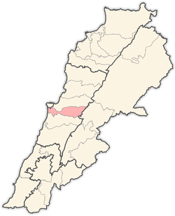 | |
This article is issued from Wikipedia - version of the 8/6/2016. The text is available under the Creative Commons Attribution/Share Alike but additional terms may apply for the media files.