Brunswick Executive Airport
| Brunswick Executive Airport | |||||||||||||||
|---|---|---|---|---|---|---|---|---|---|---|---|---|---|---|---|
|
Brunswick Executive Airport (as NAS Brunswick), October 2009 | |||||||||||||||
| IATA: NHZ[1] – ICAO: KBXM – FAA LID: BXM | |||||||||||||||
| Summary | |||||||||||||||
| Airport type | Public | ||||||||||||||
| Owner | Midcoast Regional Redevelopment Authority | ||||||||||||||
| Serves | Brunswick, Maine | ||||||||||||||
| Elevation AMSL | 75 ft / 23 m | ||||||||||||||
| Coordinates | 43°53′32″N 069°56′20″W / 43.89222°N 69.93889°W | ||||||||||||||
| Website | BrunswickExecutiveAirport.com | ||||||||||||||
| Runways | |||||||||||||||
| |||||||||||||||
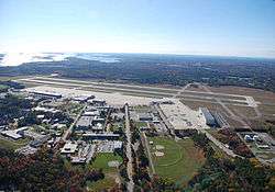
Brunswick Executive Airport (IATA: NHZ, ICAO: KBXM, FAA LID: BXM) is a public use general aviation airport located two nautical miles (4 km) southeast of the central business district of Brunswick, a town in Cumberland County, Maine, United States. It is owned by the Midcoast Regional Redevelopment Authority.[2]
The airport is located on the site of the former Naval Air Station Brunswick. The 2005 Base Realignment and Closure committee recommended the closure of NAS Brunswick. The airport was opened for civilian aircraft use in June 2011.[3]
The airport is the central focus of Brunswick Landing: Maine's Center for Innovation, a business park.[4]
Although most U.S. airports use the same three-letter location identifier for the FAA and IATA, this airport is assigned BXM by the FAA[2] but has no designation from the IATA[5] (which assigned BXM to Batom Airport in Indonesia).[6] The airport's ICAO identifier is KBXM.[7]
Facilities
Brunswick Executive Airport covers an area of 720 acres (291 ha) at an elevation of 75 feet (23 m) above mean sea level. It has two asphalt paved runways, 1L/19R and 1R/19L, each measuring 8,000 by 200 feet (2,438 x 61 m).[2]
References
- ↑ "Airline and Airport Code Search". IATA. Retrieved 1 April 2016.
- 1 2 3 4 FAA Airport Master Record for BXM (Form 5010 PDF). Federal Aviation Administration. Effective May 31, 2012.
- ↑ Levesque, Steve (June 17, 2011). "Update on Brunswick Landing". The Times Record. Retrieved July 7, 2011.
- ↑ "Reuse panel announces name for base property". The Times Record. March 17, 2010.
- ↑ "Brunswick Executive Airport (ICAO: KBXM, FAA: BXM, IATA: none)". Great Circle Mapper. Retrieved July 25, 2012.
- ↑ "Batom Airport, Indonesia (IATA: BXM)". Aviation Safety Network. Retrieved July 25, 2012.
- ↑ "Brunswick Executive – BXM (KBXM)". National Flight Data Center. Federal Aviation Administration. Retrieved July 25, 2012.
External links
- Official website
- [msrmaps.com/map.aspx?t=1&s=12&lat=43.8924&lon=-69.9368&w=700&h=900&lp=---+None+--- Aerial image as of April 1997] from USGS The National Map
- FAA Terminal Procedures for BXM, effective November 10, 2016
- Resources for this airport:
- FAA airport information for BXM
- AirNav airport information for BXM
- FlightAware airport information and live flight tracker
- SkyVector aeronautical chart for BXM
Municipalities and communities of Cumberland County, Maine, United States | ||
|---|---|---|
| Cities | 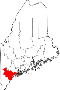 | |
| Towns | ||
| CDPs | ||
| Other villages | ||