Bruckner Expressway
| |
|---|---|
|
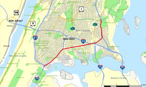
Map of the Bronx in New York City with Bruckner Expressway highlighted in red | |
| Route information | |
| Maintained by NYSDOT | |
| Length: | 7.02 mi[1] (11.30 km) |
| Component highways: |
|
| Major junctions | |
| South end: |
|
|
| |
| North end: |
|
| Highway system | |
.svg.png)
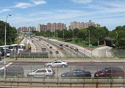
The Bruckner Expressway is a freeway in the borough of the Bronx in New York City. It carries Interstate 278 (I-278) and I-95 (and formerly I-878) from the Triborough Bridge to the south end of the New England Thruway at the Pelham Parkway interchange. The highway follows a mostly northeast–southwest alignment through the southern portion of the borough, loosely paralleling the course of the East River. It connects to several major freeways including the Bronx River Parkway, and at the Bruckner Interchange, it connects to the Cross Bronx Expressway, the Whitestone Expressway, and the Hutchinson River Parkway.
Route description
The expressway begins at the northern approach to the Triborough Bridge, where I-278 meets the southern end of I-87, here known as the Major Deegan Expressway. It heads to the northeast as an elevated highway, carrying the I-278 designation through the South Bronx. After 2 miles (3.2 km), the Bruckner Expressway meets the short Sheridan Expressway (I-895) and turns eastward to cross the Bronx River into the Soundview neighborhood. Here, the highway connects to the Bronx River Parkway at an interchange one block north of that road's official southern terminus. The Bruckner Expressway remains I-278 into the adjacent neighborhood of Castle Hill, where I-278 enters the west half of the complicated Bruckner Interchange and I-95 transitions from the Cross Bronx Expressway to the Bruckner.
In the east half of the junction, located on the opposite bank of Westchester Creek in Throggs Neck, the Bruckner Expressway (now designated I-95) intersects the Hutchinson River Parkway, I-295, and I-678. I-295 proceeds southeast from the Bruckner Interchange as the Cross Bronx Expressway Extension, while the Hutchinson Parkway and I-678 head to the north and south, respectively. The Bruckner eventually makes a turn to the north as well, connecting with I-695 in the process. The Hutchinson and the Bruckner follow mostly parallel alignments to Pelham Bay Park, where the Bruckner Expressway ends at an interchange with the Pelham Parkway. I-95 continues north from this point as the New England Thruway.
History
The Bruckner Expressway was a project envisioned by developer Robert Moses, who steered the Bruckner through the Soundview section of the Bronx, further decimating the neighborhood Moses had uprooted with his 15-year construction of the Cross Bronx Expressway, which was completed in 1963. The Bruckner Expressway opened in 1973, making it one of the last roads of the New York City Expressway system to be built. It is named in honor of former Bronx Borough President and Congressman, Henry Bruckner (1871–1942), and was built on and over the roadway of Bruckner Boulevard.[2]
Unlike the Cross Bronx Expressway, which cut through the existing street grid, the Bruckner Expressway was built along the Bruckner Boulevard alignment (except at its western end, where the Bruckner Expressway and Major Deegan Expressway meet). Between the Sheridan Expressway and the eastern end of the Bruckner Expressway, the Bruckner Boulevard is the service road, except at the Bruckner Interchange, where Bruckner Boulevard passes underneath the flying junction. West of the Sheridan Expressway, Bruckner Boulevard is underneath the expressway, and extends past the expressway's western terminus for about 0.5 miles (0.80 km), ending under the Third Avenue Bridge.
Exit list
The entire route is in the New York City borough of The Bronx.
| Location | mi[1][3] | km | Old exit | New exit | Destinations | Notes |
|---|---|---|---|---|---|---|
| Port Morris | 0.00 | 0.00 | – | – | Tolled bridge | |
| 44 | 47 | South end of I-87 | ||||
| 0.60 | 0.97 | 45 | 48 | East 138th Street | No westbound entrance | |
| Hunts Point | 1.50 | 2.41 | 46 | 49 | Eastbound exit and westbound entrance; south end of I-895 | |
| 1.90 | 3.06 | – | 50 | Hunts Point Avenue – Hunts Point Market | Westbound exit and eastbound entrance | |
| Bronx River | 2.00 | 3.22 | Drawbridge | |||
| Soundview | 2.20 | 3.54 | – | 51 | Bronx River Avenue | Westbound exit only |
| 2.30– 2.70 | 3.70– 4.35 | 51 | 52 | No westbound exit; exit 2 on Bronx Parkway | ||
| 3.00– 3.50 | 4.83– 5.63 | 52 | 53 | White Plains Road / Castle Hill Avenue | ||
| Throggs Neck | 3.60– 4.00 | 5.79– 6.44 | – | 54 | Bruckner Interchange; eastbound exit and westbound entrance; south end of Hutch Parkway; north end of I-678 | |
| 4.50 | 7.24 | 6A | Westbound exit only; exit 19 on I-678 | |||
| 4.73 | 7.61 | – | 6B | Route transition from I-278 to I-95 | ||
| Schuylerville | 5.40 | 8.69 | 7A | Southbound exit and northbound entrance | ||
| 5.50 | 8.85 | 7B | East Tremont Avenue | Southbound exit only | ||
| Country Club | 5.60– 6.00 | 9.01– 9.66 | 7C | Country Club Road – Pelham Bay Park | Northbound exit and entrance | |
| 6.00– 6.60 | 9.66– 10.62 | 8A | Westchester Avenue | No northbound exit | ||
| Pelham Bay Park | 6.50– 7.02 | 10.46– 11.30 | 8B | Orchard Beach, City Island | Via Shore Road | |
| 8C | East end of Pelham Parkway | |||||
| – | Continuation beyond Pelham Parkway | |||||
1.000 mi = 1.609 km; 1.000 km = 0.621 mi
| ||||||
See also
-
.svg.png) New York Roads portal
New York Roads portal
References
- 1 2 "2010 Traffic Volume Report for New York State" (PDF). New York State Department of Transportation. July 25, 2011. pp. 151, 205. Retrieved February 6, 2012.
- ↑ "Henry Bruckner, Lawyer, Son of Bronx President". The New York Times. August 3, 1970. p. 31. Retrieved April 4, 2010.
- ↑ Google (January 9, 2016). "Bruckner Expressway" (Map). Google Maps. Google. Retrieved January 9, 2016.