Broughton, Milton Keynes
| Broughton | |
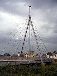 Bridge in Broughton |
|
 Broughton |
|
| Population | 2,493 (2011 Census)[1] |
|---|---|
| OS grid reference | SP895399 |
| Civil parish | Broughton |
| Unitary authority | Milton Keynes |
| Ceremonial county | Buckinghamshire |
| Region | South East |
| Country | England |
| Sovereign state | United Kingdom |
| Post town | MILTON KEYNES |
| Postcode district | MK10 |
| Dialling code | 01908 |
| Police | Thames Valley |
| Fire | Buckinghamshire |
| Ambulance | South Central |
| EU Parliament | South East England |
| UK Parliament | Milton Keynes North |
|
|
Coordinates: 52°03′00″N 0°41′38″W / 52.050°N 0.694°W
Broughton /ˈbrɔːtən/[2] is a historic village in North Buckinghamshire that has been a constituent element of Milton Keynes since the latter's designation in 1967; a civil parish; and modernly a suburb and new district of the 'city'.[3]
History and location

The name is Old English and meant village by the brook. In the Domesday Book, it is listed as owned by a Walter Giffard and the tenant was a Hugh de Bolbec. In the 6th century, its name was spelt Brotone, which is still its customary pronunciation. The original Northampton to London turnpike came through the village (to join Watling Street [now the A5 road] near Woburn).[4] The current main route, the M1 motorway, is very near and Junction 14 is barely half a mile away.
The Milton Keynes grid road, Portway (H5), forms the district's northern boundary and Tongwell Street (V11) provides its western. The section of the old turnpike, once the A50, is now part of the A5130. The original route through centre of the old village, named 'London Road', was bypassed in the early 1970s, the newer route runs between it and another MK district, Brook Furlong, and provides the eastern boundary. Finally, Chaffron Way (H7), provides the southern boundary: in mid-2009 this was extended to meet the A5130 and was opened to traffic in March 2010.
The district can be split into at least three areas. The original Broughton village forms part of a conservation area at the northern end, bounded by the brook and the A5130. Broughton Atterbury is an area of new build housing, predominantly between the Western side of the brook and the V11 grid road: this area has recently been completed and is awaiting final road surfacing. Broughton Gate is a new area, part of the Milton Keynes Eastern Expansion area and covers the area to the East of the brook. The iconic cable-stayed bridge is one of two main road crossing across Broughton Brook, the third and newest is the newly completed H7 extension between Broughton and the neighbouring district of Kingston.
Education
Broughton Fields primary school and Brooklands Farm primary school serve the area, whilst secondary education is provided by Oakgrove School in nearby Middleton. In addition, Broughton Manor Preparatory school, a private prep school, is also situated near to the old village.
Facilities
The facilities in the area include a "Hungry Horse" chain public house, and a range of small shops, hair dressers and convenience stores.
Broughton is within easy walking distance of the Milton Keynes park and ride service to Central Milton Keynes. The Kingston Shopping Centre, which includes one of the UK's largest Tesco stores, a McDonald's and a Dominos Pizza outlet, is nearby.
A site for a community playing fields has been also been identified between the old village and the primary school. Broughton Pavilion is located on the edge of this field and hosts a variety of groups.
The Broughton Brook linear park stretches the length of the brook as it travels through the area. This provides recreation space for residents. In the North end of Broughton, there is considerable open space and a conservation area. Although the population of this area has grown considerably, this open space is underused and provides a quiet retreat.
Civil parish
As of March 2013, Broughton CP operates as a joint parish council with Milton Keynes village CP, known as Broughton and Milton Keynes Parish Council.[5]
St Lawrence's Church
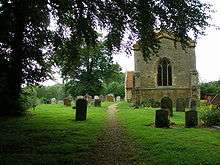
St Lawrence's Church in Broughton is 14th-century church with a 15th-century tower. A series of wall paintings covering large parts of the north and south walls, discovered during an 1849 restoration, are the chief interest of the church. The paintings include a 14th-century Pietà, a Doom, St Helena and St Eligius, and St George slaying the Dragon.[4][6]
The Rectors of St Lawrence are recorded from the end of 1261 to date, many may be interned within the grounds of St Lawrence.[7]
Canal development
The planned new waterway (Bedford & Milton Keynes Waterway) between Milton Keynes and Bedford will run through Broughton Brook[8]
References
- ↑ Neighbourhood Statistics 2011 Census, Accessed 3 February 2013
- ↑ Hanks, Patrick; Flavia Hodges; A. D. Mills; Adrian Room (2002). The Oxford Names Companion. Oxford: Oxford University Press. pp. 961–962.
- ↑ Formally, Milton Keynes is still a town. However, since it is an amalgam of many towns and villages, the local custom is to use the term 'city', albeit loosely
- 1 2 'Parishes : Broughton' – Victoria History of the Counties of England, A History of the County of Buckingham: Volume 4 (1927), pp. 303–308. Date accessed: 24 August 2009
- ↑ Parishes in Milton Keynes Archived 8 June 2009 at the Wayback Machine. – Milton Keynes Council.
- ↑ "Archived copy". Archived from the original on 17 March 2009. Retrieved 2009-08-22.
- ↑ Rectors of St Lawrence Broughton since 1261 Milton Keynes Heritage Association
- ↑ Bedford-MK Waterway
External links
- The website of the joint Broughton and Milton Keynes civil parish council.
- VisitChurches.org entry for St Lawrences.
- 'Parishes : Broughton' – Victoria History of the Counties of England, A History of the County of Buckingham: Volume 4 (1927), pp. 303–308.
External links
![]() Media related to Broughton, Milton Keynes at Wikimedia Commons
Media related to Broughton, Milton Keynes at Wikimedia Commons