Brotherhood and Unity Highway
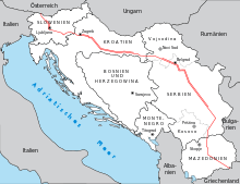
The Brotherhood and Unity Highway (Croatian: Autocesta "Bratstvo i jedinstvo"; Macedonian: Автопат „Братство и единство“; Slovene: Cesta bratstva in enotnosti or Avtocesta bratstva in enotnosti, Serbian: Autoput "Bratstvo i jedinstvo", Аутопут "Братство и јединство") was a highway that stretched over 1,182 km (734 mi)[1] across former Yugoslavia, from the Austrian border at Rateče near Kranjska Gora in the northwest via Ljubljana, Zagreb, Belgrade and Skopje to Gevgelija on the Greek border in the southeast. It was the one and only modern highway in the country, connecting four constituent states.
History

Construction began on the initiative of President Josip Broz Tito, who called the project the "Road of brotherhood and unity" (Autoput bratstva i jedinstva) after the motto of the League of Communists of Yugoslavia. A first section between Zagreb and Belgrade, built with the effort of the Yugoslav People's Army and volunteer Youth Labour Brigades, opened in 1950. The section between Ljubljana and Zagreb was built by 54,000 volunteers in less than eight months in 1958.[2]
Its importance caused it to be colloquially named autoput or autocesta (generic Serbo-Croatian expressions for "highway", "motorway"). This use has since largely faded out, after the successor states built further motorways.
In the 1960s and 1970s the autoput became a much frequented holiday route for Turkish immigrants in West Germany and Austria (then called Gastarbeiter) visiting their original homeland during the summer vacation time, and for tourists to southeastern Europe. Entering communist but non-aligned Yugoslavia was far easier, for people from NATO countries such as West Germany and Turkey, than entering any of the Warsaw Pact communist countries of the Balkan region that might have provided alternative routes.
Originally an ordinary road, the carriageway used to be congested with cars and trucks, especially in summertime, when overtired long-distance drivers caused numerous accidents. Wrecked cars usually remained in place for long periods of time, providing a grim reminder of the dangers of the highway. The situation slightly improved after some parts were brought up to modern motorway standards (two lanes for each direction plus an emergency lane) on the following sections built between 1977 and 1991:
- Kranj–Ljubljana: 20 km
- Jankomir interchange (Zagreb bypass)–Slavonski Brod (east): 207 km
- Sremska Mitrovica–Belgrade–Niš: 277 km
In 1991, several sections were affected by the Yugoslav wars, bringing severe damage, and causing the traffic to be almost completely discontinued in places.
International categorization
Since 1975, the road was concurrent with the following routes of the International E-road network:
- European route E61: Villach–Kranj–Ljubljana
- European route E70: Ljubljana–Zagreb–Sisak–Slavonski Brod–Belgrade
- European route E75: Belgrade–Niš–Skopje-Veles–Thessaloniki
Legacy
Since 1994 the route is also part of the Pan-European corridor X that extends from Salzburg to Thessaloniki.
The road has been continuously upgraded. As of 2011, it is a modern motorway in its entire length through:
- Slovenia - the A2 motorway
- Croatia - the A3 motorway,
and most of its length through:
- Serbia - the A3 motorway west of Belgrade and the A1 motorway south of Belgrade
- Macedonia - the M-1 motorway.
As of 2015, the only remaining non-motorway sections are a total of 70 km (43 mi) in southern Serbia around Vranje and the Grdelica Gorge, and 33 km (21 mi) in Macedonia south of Demir Kapija.
References
- ↑ Sić 1990, p. 23.
- ↑ Lubej, Uroš (28 November 2008). "Nova razstava v Dolenjskem muzeju: Cesta, ki je spremenila Dolenjsko" [The New Exhibition in the Lower Carniolan Museum: The Road that Transformed the Lower Carniola]. Park.si (in Slovenian).
Sources
- Sić, Miroslav (June 1990). "Problematika razvoja autocesta u Hrvatskoj i Jugoslaviji na pragu 90. godina" [Development of Motorways in Croatia and Yugoslavia on the Threshold of the Nineties] (PDF). Geografski glasnik (in Croatian). 52 (1): 13–29. Retrieved 13 December 2015.
External links
 Media related to Brotherhood and Unity Highway at Wikimedia Commons