Brooklyn, Portland, Oregon
| Brooklyn | |
|---|---|
| Neighborhood | |
 Brooklyn | |
| Coordinates: 45°29′38″N 122°39′10″W / 45.49401°N 122.65280°WCoordinates: 45°29′38″N 122°39′10″W / 45.49401°N 122.65280°W | |
| Country | United States |
| State | Oregon |
| City | Portland |
| Government | |
| • Association | Brooklyn Action Corps |
| • Coalition | Southeast Uplift Neighborhood Program |
| Area | |
| • Total | 0.90 sq mi (2.34 km2) |
| Population (2000)[1] | |
| • Total | 3,542 |
| • Density | 3,920/sq mi (1,514/km2) |
| Housing[1] | |
| • No. of households | 1672 |
| • Occupancy rate | 95% occupied |
| • % households renting | 63% renting |
| • Avg. household size | 2.12 persons |
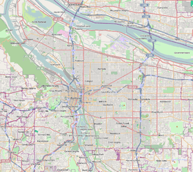
Brooklyn is a mostly residential neighborhood in southeast Portland, Oregon. It sits along the east side of the Willamette River in the vicinity of Reed College. Founded as a neighborhood in the late 1860s, the neighborhood today is a middle-class area comprising mainly single family homes, interspersed with remaining industrial sites along the river and a large railyard. This railyard is home to Southern Pacific 4449 as well as several other large antique steam and diesel-electric locomotives.
History
The area of the neighborhood was inhabited by Clackamas people before settlement by whites. The first white settler in the area of was Giddeon Tibbets, who acquired the land in the Donation Land Claim Act of 1850. He settled the area in 1851, building a family home and grist mill. Tibbets named the area "Brookland" due to the river, creeks, and lakes on his property. In 1868 Tibbets subdivided the property into smaller lots and allowed the Oregon Central Railroad to cross the property. The rail line and the subdivision quickly brought in a large number of residents to the neighborhood, which acquired its current name of "Brooklyn". The influx lead to the construction of a town square at the corner of Powell Boulevard and Milwaukie Avenue. In the 1890s, the neighborhood received an influx of largely Roman Catholic German-Americans. While many of the German street/landmark names were changed during World War I, the neighborhood continues to bear the traces of this period today, with several older German-American businesses, as well as the Sacred Heart Catholic Church and the 1891 Johan Poulsen House. In 1908, The contracting firm Giebisch and Joplin built this neighborhood's original sewer system. [2] In the 1920s, the neighborhood changed drastically as a part of a city-wide construction effort. The construction of the Ross Island Bridge over the Willamette destroyed the town square. At the same time, many of the streams and ponds in the neighborhood were filled in. The construction of McLoughlin Boulevard (Oregon Route 99E) severed the neighborhood's connection to the Willamette waterfront. The construction of an overpass on 17th avenue also divided the neighborhood in two.
By the 1960s, the neighborhood had acquired the reputation as being poverty-stricken. It was during this time that past Portland mayor Tom Potter began his police career in Portland, as a beat officer in the neighborhood, as well as nearby Sellwood to the south. According to Potter, he acquired many of the basic tenets of his philosophy of community policing while as a young officer in the neighborhood. Potter became involved in the Brooklyn Action Corps (BAC), a community organization that was founded during this time to combat the poverty, crime, and drugs that were afflicting the neighborhood.
By the 1980s, the neighborhood had undergone a nearly complete turnaround. Today it is regarded as among southeast Portland's most desirable residential neighborhoods. The construction of the Eastbank Esplanade in Portland allowed the neighborhood to regain its connection to the Willamette River, and the opening of the Orange Line light rail, completed in September 2015, has created easier mass-transit access to downtown.
References
- 1 2 Demographics (2000)
- ↑ "Row at Executive Board Meeting" The Oregonian (Portland Oregon) June 24 1909
External links
| Wikimedia Commons has media related to Brooklyn, Portland, Oregon. |
|