Britzer Garten
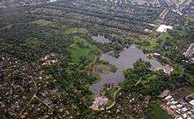
The Britzer Garten, a large park in the south of Berlin, was designated after the local part Britz of Berlin's borough Neukoelln. It was constructed for the Bundesgartenschau 1985, in order to provide a new landscape park to the citizens in the southeast of West-Berlin, who were at that time cut off from the surrounding countryside. The park covers an area of 90 hectares and offers nature and garden architecture (rose garden, rhododendron woods), playgrounds, lakes and hills as well as multicolored flower patches, matching the particular season and extensive lawns for any leisure activities. Architecture and art (e.g. the "Karl Foerster pavilion") play a vital role in the park. Along the restaurant at the "Kalenderplatz" the largest sundial of Europe and a solar system walkway, measuring 99 metres of diameter can be seen. It was planned by architects Juergen Dirk Zilling, Jasper Halfmann and Klaus Zillich. The "Café am See" was built in 1985 by the architect Engelbert Kremser, using his earthwork technology.
The "Britzer Museumsbahn" railroad, runs on a 600 mm track through the Britzer Garten . Some engines and cars are remakes of historical models.
Many special events also take place there, including concerts (classical and other) sometimes accompanied by big fireworks.
The main entrance is situated at the Buckower Damm, near the park cemetery in Neukoelln. The sculpture Fette Henne (Berlin-Neukölln), artwork in the Britzer Garten by artist Rolf Szymanski is at the entrance.
Visitors are charged a small entrance fee at the gates. Dogs and bicycles are not allowed.
The Britzer Garten belongs to the Grün Berlin Park und Garten GmbH company, which is owned by the city of Berlin. Other places of attraction run by this company are the Britzer Mühle, the Erholungspark Marzahn (opened as the "Berliner Gartenschau" 1987) and the Natur-Park Schöneberger Südgelände (a former EXPO-2000-project).
Bibliography
- Clemens Alexander Wimmer: Parks und Gärten in Berlin und Potsdam; ed. Senator für Stadtentwicklung und Umweltschutz, Abt. III – Gartendenkmalpflege; Nicolaische Verlagsbuchhandlung: 3. Aufl. Berlin 1989; ISBN 3-87584-267-7; S. 84-91.
External links
| Wikimedia Commons has media related to Britzer Garten. |
- Official website
- German Wikipedia article on the Britzer Garten, featuring images.
Coordinates: 52°26′N 13°25′E / 52.433°N 13.417°E