Crowsnest Highway

.png)
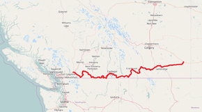
The Crowsnest Highway is an east-west highway in British Columbia and Alberta, Canada. It stretches 1,161 km (721 mi) across the southern portions of both provinces, from Hope, British Columbia to Medicine Hat, Alberta, providing the shortest highway connection between the Lower Mainland and southeast Alberta through the Canadian Rockies. The mostly two-lane highway was officially designated in 1932, mainly following a mid-19th century gold rush trail originally traced out by an engineer named Edgar Dewdney. It takes its name from the Crowsnest Pass, the location at which the highway crosses the Continental Divide between British Columbia and Alberta.
In British Columbia, the highway is entirely in mountainous regions and is also known as the Southern Trans-Provincial Highway. The first segment between the Trans-Canada Highway and Highway 5A is locally known as the Hope-Princeton Highway, and passes by the site of the Hope Slide. In Alberta, terrain is initially mountainous, before smoothing to foothills and eventually generally flat prairie in the vicinity of Pincher Creek. The highway forms part of the Red Coat Trail and the CANAMEX Corridor from Highway 2 near Fort Macleod to Highway 4 in Lethbridge.
Route description
Crowsnest Highway is designated a core route in Canada's National Highway System, and is designated as Highway 3 for its entire length.[1]
British Columbia
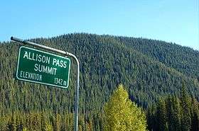
The Crowsnest Highway's total length in British Columbia is 838 km (521 mi), and its total length within Alberta is 323 km (201 mi).[2] The Crowsnest Highway's western terminus is at Hope, where it branches off from Highway 1. The highway goes east for 7 km (4.3 mi) to its junction with Highway 5, then through Allison Pass and Manning Provincial Park for 127 km (79 mi) towards the Town of Princeton. There are several significant ascents in this stretch between Hope and Princeton. The first is the steep climb to the Hope Slide, followed later by the remainder of the climb up to Allison Pass at an elevation of 1,342 m (4,403 ft). After the summit of Allison Pass, where the Crowsnest crosses from the Fraser Valley Regional District into the Regional District of Okanagan-Similkameen, the road descends for 40 km (25 mi) before beginning another long climb up Sunday Summit (1,284 m (4,213 ft)). Soon after Sunday Summit is the descent into Princeton, where Highway 5A begins.[3]
After Princeton, the Crowsnest goes southeast for 67 km (42 mi), through Hedley, to the Village of Keremeos, where a junction with a length of highway designated as 3A is located, leading towards Penticton and Highway 97. Another 46 km (29 mi) southeast, and the Crowsnest reaches the Town of Osoyoos and a junction with Highway 97. The highway then proceeds to hug the Canada-U.S. border east through a stretch of switchbacks known as Anarchist Mountain, which is also the name of the upland rural community beyond the summit. A few kilometres east of Anarchist Mountain, the Crowsnest enters the Regional District of Kootenay Boundary.[3]
52 km (32 mi) east of Osoyoos, the Crowsnest reaches its junction with Highway 33 at Rock Creek, then the highway heads east for 70 km (43 mi) to its junction with Highway 41 at a location called Carson, just west of Grand Forks. Another 26 km (16 mi) east, passing through Grand Forks en route, the Crowsnest meets Highway 395 at the southern end of Christina Lake.[3]
Further east from Christina Lake, the Crowsnest travels for 47 km (29 mi) through Bonanza Pass to its junction with Highway 3B at Nancy Greene Lake, which is the cutoff to the town of Rossland and Red Mountain Resort, shortly thereafter crossing into the Regional District of Central Kootenay. It is another 26 km (16 mi) east from Nancy Greene Lake to the junction with Highway 22 at Castlegar, and another 2 km (1.2 mi) east to a junction with another stretch of Highway designated as 3A, also within Castlegar. Leaving Castlegar, the Crowsnest reaches its eastern junction with Highway 3B 26 km (16 mi) east. Highway 6 converges with the Crowsnest at Salmo, 11 km (6.8 mi) east of the 3B junction, and the two highways proceed south for 14 km (8.7 mi) to the Burnt Flat Junction, where Highway 6 diverges south.[3]
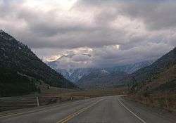
East of Burnt Flat, the Crowsnest heads through the Kootenay Pass on a stretch known as the Kootenay Skyway, or Salmo-Creston Skyway. 67 km (42 mi) east of Burnt Flat, the Crowsnest reaches the Town of Creston, just past junctions with Highway 21 and Highway 3A. 40 km (25 mi) later, south of Yahk, Highway 95 merges onto the Crowsnest. The two highways share a common alignment for 72 km (45 mi) northeast along the Moyie River, crossing into the Regional District of East Kootenay along the way, to a junction with Highway 95A at Cranbrook. Another 6 km (3.7 mi) east, Highway 95 diverges north from the Crowsnest and Highway 93 merges onto the Crowsnest from the north. Highway 93 and the Crowsnest share a common alignment for the next 53 km (33 mi) southeast to Elko, where Highway 93 diverges south. 31 km (19 mi) north of Elko, the Crowsnest reaches Fernie, then it goes north another 30 km (19 mi) to its junction with Highway 43 at Sparwood, and another 19 km (12 mi) east, the highway reaches the boundary with Alberta at Crowsnest Pass.[3]
Alberta
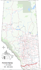
The Alberta portion of the Crowsnest Highway is designated Alberta Provincial Highway No. 3. In Alberta, the Crowsnest Highway goes east 16 km (9.9 mi) to the Bighorn Highway at Coleman, then 26 km (16 mi) east to its junction with Highway 22, another 20 km (12 mi) to its junction with Highway 6, then another 44 km (27 mi) to its junction with Highway 2 north, then proceeding 5 km (3.1 mi) east into the Town of Fort Macleod and the Crowsnest's junction with Highway 2 south. After Fort Macleod, the Crowsnest goes 27 km (17 mi) east, crossing the Oldman River, to Highway 3A southeast of Monarch, which feeds Highway 23.[4]
The highway reaches the first access (Westview Drive W) to the City of Lethbridge 13 km (8.1 mi) later.[4] At this point, the Crowsnest's only freeway segment begins. 2 km (1.2 mi) later, Highway 25 (University Drive W) branches to the north before crossing the Oldman River for the second time. The freeway segment ends at Mayor Magrath Drive, which branches as Highway 5 to the south. The highway intersects Highway 4 at the eastern limits of Lethbridge.[4]
45 km (28 mi) east of Lethbridge, the highway reaches the Town of Taber.[4] Within Taber, Highway 36 runs concurrently with the highway for 3 km (1.9 mi). Upon dropping the concurrency, the Crowsnest ends 113 km (70 mi) later at the Trans-Canada Highway in the City of Medicine Hat.
Future
Alberta Transportation has proposed the construction of a Lethbridge bypass to render the CANAMEX Corridor free-flowing through southern Alberta, in combination with proposed bypasses of Fort Macleod, Claresholm and Nanton.[2][5] The route would split from Crowsnest Highway just prior to Coalhurst, bypassing it, Lethbridge, and Coaldale before rejoining the existing highway.[5]
Major intersections
British Columbia
The following is a list of major intersections along British Columbia Highway 3 (Crowsnest Highway).[6][7]
| Regional district | Location | km[8] | mi | Exit | Destinations | Notes | |
|---|---|---|---|---|---|---|---|
| Continues as | |||||||
| Fraser Valley | Hope | 0.00 | 0.00 | 170 | Hope interchange No westbound exit West end of BC 5 concurrency. | ||
| 0.99 | 0.62 | 171 | Westbound exit only | ||||
| 3.08 | 1.91 | 173 | Old Hope-Princeton Way | Thacker Creek interchange No westbound entrance | |||
| | 6.67 | 4.14 | 177 | Othello interchange East end of BC 5 concurrency. | |||
| E. C. Manning Provincial Park | 25.04 | 15.56 | West end of E. C. Manning Provincial Park (Manning Park). | ||||
| ↑ / ↓ | 58.02 | 36.05 | Allison Pass – el. 1,342 m (4,403 ft) | ||||
| Okanagan-Similkameen | 83.00 | 51.57 | East end of E. C. Manning Provincial Park (Manning Park). | ||||
| | 99.77 | 61.99 | Sunday Summit – el. 1,284 m (4,213 ft) | ||||
| Princeton | 133.56 | 82.99 | Vermillion Avenue, Burton Avenue | ||||
| 133.93 | 83.22 | ||||||
| Keremeos | 200.62 | 124.66 | 7 Avenue, 7 Street | BC 3 branches north. | |||
| 201.11 | 124.96 | BC 3 branches east. | |||||
| | 225.63 | 140.20 | Nighthawk Road – Nighthawk (WA) | ||||
| Osoyoos | 247.11 | 153.55 | |||||
| 248.23 | 154.24 | Main Street, Spartan Drive, 83 Street | BC 3 branches south, then turns east. | ||||
| 248.80 | 154.60 | Osoyoos Trestle Bridge across Osoyoos Lake | |||||
| Kootenay Boundary | Rock Creek | 299.12 | 185.86 | ||||
| Midway | 318.26 | 197.76 | Florence Street | ||||
| Greenwood | 331.44 | 205.95 | Greenwood Street | ||||
| | 368.53 | 228.99 | |||||
| Grand Forks | 372.32 | 231.35 | 19 Street | ||||
| 372.97 | 231.75 | Boundary Drive | |||||
| 373.97 | 232.37 | 5 Street | |||||
| 374.16 | 232.49 | 2 Street | |||||
| | 392.10 | 243.64 | |||||
| Christina Lake | 394.55 | 245.16 | West Lake Drive, Swanson Road | ||||
| | 406.39 | 252.52 | Bonanza Pass – el. 1,535 m (5,036 ft) | ||||
| Nancy Greene Provincial Park | 441.53 | 274.35 | |||||
| Central Kootenay | Castlegar | 467.95 | 290.77 | Kinnaird interchange | |||
| 468.15 | 290.89 | 20 Street, 6 Avenue to BC 22 | Westbound only | ||||
| 468.78 | 291.29 | Crosses Columbia River | |||||
| 469.21 | 291.55 | Ootischenia interchange | |||||
| | 495.67 | 308.00 | |||||
| Salmo | 506.07 | 314.46 | West end of BC 6 concurrency | ||||
| | 520.23 | 323.26 | East end of BC 6 concurrency. | ||||
| | 543.27 | 337.57 | Kootenay Pass – el. 1,774 m (5,820 ft) | ||||
| | 582.34 | 361.85 | Crosses Kootenay River | ||||
| Creston | 585.08 | 363.55 | |||||
| 586.50 | 364.43 | BC 3 branches south. | |||||
| 589.30 | 366.17 | 10 Avenue N, Cook Street | BC 3 turns east. | ||||
| 589.80 | 366.48 | 16 Avenue | |||||
| Yahk | 626.59 | 389.34 | West end of BC 95 concurrency | ||||
| East Kootenay | Cranbrook | 695.07 | 431.90 | King Street, 9 Avenue S | |||
| 695.89 | 432.41 | 6 Street N | |||||
| 696.80 | 432.97 | Victoria Avenue, Theatre Road | |||||
| 697.46 | 433.38 | Willowbrook Drive | |||||
| 698.05 | 433.75 | 22 Street N | |||||
| 698.91 | 434.28 | Cranbrook interchange | |||||
| | 704.34 | 437.66 | Fort Steele interchange; east end of BC 95 concurrency; west end of BC 93 concurrency | ||||
| | 730.34 | 453.81 | Wardner Bridge across Kootenay River | ||||
| Elko | 760.08 | 472.29 | West end of BC 93 concurrency. | ||||
| | 788.75 | 490.11 | Mount Fernie Park Road – Fernie Alpine Resort | ||||
| Fernie | 791.20 | 491.63 | 4 Street | ||||
| 791.54 | 491.84 | 7 Street | |||||
| 792.20 | 492.25 | 13 Street | |||||
| 792.71 | 492.57 | 9 Avenue | |||||
| Sparwood | 821.32 | 510.34 | Red Cedar Drive | ||||
| 821.89 | 510.70 | ||||||
| | 841.29 | 522.75 | Alberta – British Columbia border Crowsnest Pass – el. 1,358 m (4,455 ft) | ||||
| Continues as Alberta Highway 3 east | |||||||
1.000 mi = 1.609 km; 1.000 km = 0.621 mi
| |||||||
Alberta
The following is a list of major intersections along Alberta Highway 3 (Crowsnest Highway) from west to east.[2][9]
| Rural/specialized municipality | Location | km | mi | Destinations | Notes | ||
|---|---|---|---|---|---|---|---|
| Continues as British Columbia Highway 3 west | |||||||
| Municipality of Crowsnest Pass | | 0 | 0.0 | Alberta – British Columbia border Crowsnest Pass – el. 1,358 m (4,455 ft) | |||
| Coleman | 16 | 9.9 | |||||
| Blairmore | 18 | 11 | 20 Avenue east | ||||
| 21 | 13 | 20 Avenue west | |||||
| Frank | 24 | 15 | 153 Street | Passes Frank Slide | |||
| Bellevue | 26 | 16 | 9 Avenue / 213 Street | Access to Hillcrest | |||
| | 30 | 19 | East Hillcrest Drive | Access to Hillcrest | |||
| M. D. of Pincher Creek No. 9 | Burmis | 35 | 22 | ||||
| | 40 | 25 | |||||
| | 42 | 26 | |||||
| Lundbreck | 44 | 27 | Breckenridge Avenue | ||||
| | 48 | 30 | |||||
| Cowley | 52 | 32 | |||||
| Pincher Station | 62 | 39 | |||||
| | 65 | 40 | |||||
| Piikani I.R. 147 | Brocket | 77 | 48 | ||||
| M. D. of Willow Creek No. 26 | | 102 | 63 | Future Hwy 3X east[2] | Future Fort Macleod bypass (Phase 2)[10] | ||
| | 104 | 65 | |||||
| | 105 | 65 | Divided highway begins | ||||
| Fort Macleod | 106 | 66 | Hwy 2 concurrency begins CANAMEX Corridor concurrency begins | ||||
| Future Hwy 2X south[2] | Future Fort Macleod bypass (Phase 1)[10] | ||||||
| 108 | 67 | One-way road pair begins | |||||
| 109 | 68 | ||||||
| 110 | 68 | One-way road pair ends | |||||
| 111 | 69 | Hwy 2 concurrency ends | |||||
| Future Hwy 2X north[2] | Future Fort Macleod bypass (Phase 1)[10] | ||||||
| | 132 | 82 | Eastbound access to Hwy 23. | ||||
| ↑ / ↓ | | 134 | 83 | Crosses Oldman River | |||
| Lethbridge County | | 138 | 86 | Partial interchange Westbound exit, eastbound entrance | |||
| | 142 | 88 | Future Hwy 3X east[2] | Future Lethbridge and Coaldale bypass.[11] | |||
| Kipp | 146 | 91 | |||||
| Coalhurst | 148 | 92 | 51 Avenue | Coalhurst access road | |||
| Freeway begins | |||||||
| City of Lethbridge | 151 | 94 | Westside Drive W Hwy 3A east (unsigned highway) | Partial interchange Eastbound exit, westbound entrance. | |||
| 153.1 | 95.1 | Interchange | |||||
| 155.0 | 96.3 | Bridge Drive W (Former Hwy 3A west) | Interchange | ||||
| 155.4 | 96.6 | Crosses Oldman River | |||||
| 155.6 | 96.7 | Access road to Oldman River valley | |||||
| 156.1 | 97.0 | 5 Avenue N (to Scenic Drive) | Eastbound exit, westbound entrance | ||||
| 156.3 | 97.1 | 1 Avenue S – City Centre To | Eastbound exit only | ||||
| 156.8 | 97.4 | Scenic Drive | Westbound exit, eastbound entrance | ||||
| 157.7 | 98.0 | Stafford Drive | |||||
| 158.5 | 98.5 | 13 Street | Westbound to northbound exit only | ||||
| 159.2 | 98.9 | 19 Street (to 3 Avenue S) | Eastbound exit/entrance | ||||
| 159.4 | 99.0 | Mayor Magrath Drive | |||||
| Freeway ends | |||||||
| 161.4 | 100.3 | 1 Avenue S To | Eastbound exit only | ||||
| 161.8 | 100.5 | 43 Street | CANAMEX Corridor concurrency ends | ||||
| Lethbridge County | | 168 | 104 | Future Hwy 4X[2] | Future Lethbridge bypass.[11] | ||
| Coaldale | 173 | 107 | |||||
| | 184 | 114 | Future Hwy 3X west[2] | Future Lethbridge and Coaldale bypass.[11] | |||
| M. D. of Taber | | 198 | 123 | ||||
| Barnwell | 200 | 120 | Heritage Road | ||||
| | 202 | 126 | |||||
| Taber | 207 | 129 | |||||
| 208 | 129 | Hwy 36 concurrency begins. | |||||
| 210 | 130 | Hwy 36 concurrency ends. | |||||
| 211 | 131 | Divided highway ends | |||||
| Grassy Lake | 242 | 150 | |||||
| County of Forty Mile No. 8 | Burdett | 254 | 158 | Main Street | Passes through Burdett | ||
| | 260 | 160 | |||||
| Bow Island | 266 | 165 | Centre Street | Passes through Bow Island | |||
| | 285 | 177 | |||||
| Cypress County | Seven Persons | 301 | 187 | ||||
| | 312 | 194 | Future Hwy 1X[2] | Future Medicine Hat bypass.[12] | |||
| City of Medicine Hat | 321 | 199 | |||||
| 322 | 200 | ||||||
| 323 | 201 | Hwy 3 ends. | |||||
| Continues as | |||||||
1.000 mi = 1.609 km; 1.000 km = 0.621 mi
| |||||||
See also
- Dewdney Trail
- Kettle Valley Railway (southern mainline of the CPR)
- CANAMEX Corridor
- Pan-American Highway
- Red Coat Trail
References
- ↑ "National Highway System". Transport Canada. December 13, 2009. Retrieved March 16, 2011.
- 1 2 3 4 5 6 7 8 9 10 "Provincial Highways 1 - 216 Progress Chart" (PDF). Alberta Transportation. March 2015. Retrieved 28 April 2016.
- 1 2 3 4 5 Google (October 31, 2016). "Crownest Highway in British Columbia" (Map). Google Maps. Google. Retrieved October 31, 2016.
- 1 2 3 4 Google (October 31, 2016). "Crownest Highway in Alberta" (Map). Google Maps. Google. Retrieved October 31, 2016.
- 1 2 "Highways 3 & 4 - Lethbridge and Area NHS & NTSC Functional Planning Study - Final Report" (PDF). Stantec Consulting Ltd. Alberta Transportation. February 2006. Retrieved October 28, 2016.
- ↑ Super, Natural British Columbia Road Map & Parks Guide (Map) (2010-2011 ed). Davenport Maps Ltd. in co-operation with Tourism British Columbia. § L-9, § L-10, § L-11, and § L-12.
- ↑ British Columbia Road Atlas (2007 ed.). Oshawa, ON: MapArt Publishing Corp. pp. 69-75.
- ↑ Nicol, Matthew; Horel, Steve (July 2015). "Landmark Kilometre Inventory" (PDF). British Columbia Ministry of Transportation and Infrastructure. Cypher Consulting. pp. 74–113.
- ↑ Alberta Official Road Map (Map) (2010 ed.). Alberta Tourism, Parks and Recreation. § N-5, N–6, N-7, N–8.
- 1 2 3 "HIGHWAYS 2 and 3 Fort Macleod Bypass Functional Planning Study" (PDF). Alberta Transportation. McElhanney. Retrieved 20 June 2016.
- 1 2 3 Stantec (February 2006). "Highways 3 & 4 - Lethbridge and Area NHS & NSTC: Functional Planning Study" (PDF). Alberta Transportation. Retrieved 28 April 2016.
- ↑ Stantec (2008). "Highway 1 & 3 Functional Planning Study" (PDF). Alberta Transportation. Retrieved 28 April 2016.