Bristol, Florida
| Bristol, Florida | |
|---|---|
| City | |
|
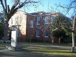
County courthouse | |
 Location in Liberty County and the state of Florida | |
| Coordinates: 30°25′37″N 84°58′45″W / 30.42694°N 84.97917°WCoordinates: 30°25′37″N 84°58′45″W / 30.42694°N 84.97917°W | |
| Country |
|
| State |
|
| County | Liberty |
| Area | |
| • Total | 1.6 sq mi (4.2 km2) |
| • Land | 1.6 sq mi (4.2 km2) |
| • Water | 0 sq mi (0 km2) |
| Elevation | 174 ft (53 m) |
| Population (2000) | |
| • Total | 845 |
| • Density | 528.1/sq mi (201.2/km2) |
| Time zone | Eastern (EST) (UTC-5) |
| • Summer (DST) | EDT (UTC-4) |
| ZIP code | 32321 |
| Area code(s) | 850 |
| FIPS code | 12-08600[1] |
| GNIS feature ID | 0279406[2] |
| Website | cityofbristolflorida.org |
Bristol is a city in and the county seat of Liberty County, Florida, United States.[3] The population was 845 at the 2000 census; in 2005, the population according to U.S Census estimates was 910. Two schools are based in Bristol: Liberty County High School and W. R. Tolar Elementary and Middle School.
Geography
Bristol is located at 30°25′37″N 84°58′45″W / 30.427063°N 84.979099°W.[4] In the Florida panhandle.
According to the United States Census Bureau, the city has a total area of 1.6 square miles (4.1 km2), all land.
Climate
| Climate data for Bristol, Florida | |||||||||||||
|---|---|---|---|---|---|---|---|---|---|---|---|---|---|
| Month | Jan | Feb | Mar | Apr | May | Jun | Jul | Aug | Sep | Oct | Nov | Dec | Year |
| Record high °F (°C) | 83 (28) |
85 (29) |
90 (32) |
92 (33) |
100 (38) |
102 (39) |
102 (39) |
101 (38) |
98 (37) |
95 (35) |
87 (31) |
84 (29) |
102 (39) |
| Average high °F (°C) | 64 (18) |
67 (19) |
74 (23) |
79 (26) |
86 (30) |
90 (32) |
91 (33) |
90 (32) |
88 (31) |
81 (27) |
73 (23) |
66 (19) |
79.1 (26.1) |
| Daily mean °F (°C) | 52 (11) |
55 (13) |
61 (16) |
66 (19) |
74 (23) |
79 (26) |
81 (27) |
80 (27) |
77 (25) |
69 (21) |
61 (16) |
54 (12) |
67.4 (19.7) |
| Average low °F (°C) | 40 (4) |
42 (6) |
48 (9) |
52 (11) |
61 (16) |
68 (20) |
71 (22) |
70 (21) |
66 (19) |
57 (14) |
49 (9) |
42 (6) |
55.5 (13.1) |
| Record low °F (°C) | 4 (−16) |
0 (−18) |
19 (−7) |
31 (−1) |
36 (2) |
49 (9) |
60 (16) |
59 (15) |
48 (9) |
33 (1) |
20 (−7) |
12 (−11) |
0 (−18) |
| Average precipitation inches (mm) | 4.80 (121.9) |
4.92 (125) |
5.86 (148.8) |
3.68 (93.5) |
5.04 (128) |
5.92 (150.4) |
7.36 (186.9) |
6.78 (172.2) |
4.15 (105.4) |
4.11 (104.4) |
3.51 (89.2) |
3.77 (95.8) |
59.9 (1,521.5) |
| Source: The Weather Channel[5] | |||||||||||||
Demographics
| Historical population | |||
|---|---|---|---|
| Census | Pop. | %± | |
| 1960 | 614 | — | |
| 1970 | 626 | 2.0% | |
| 1980 | 1,044 | 66.8% | |
| 1990 | 937 | −10.2% | |
| 2000 | 845 | −9.8% | |
| 2010 | 996 | 17.9% | |
| Est. 2015 | 976 | [6] | −2.0% |
As of the census[1] of 2000, there were 845 people, 326 households, and 235 families residing in the city. The population density was 517.1 people per square mile (200.2/km²). There were 393 housing units at an average density of 240.5 per square mile (93.1/km²). The racial makeup of the city was 87.22% White, 3.79% African American, 1.78% Native American, 5.44% from other races, and 1.78% from two or more races. Hispanic or Latino of any race were 5.80% of the population.
There were 326 households out of which 30.7% had children under the age of 18 living with them, 52.8% were married couples living together, 14.1% had a female householder with no husband present, and 27.9% were non-families. 25.8% of all households were made up of individuals and 12.0% had someone living alone who was 65 years of age or older. The average household size was 2.48 and the average family size was 2.91.
In the city the population was spread out with 24.9% under the age of 18, 8.5% from 18 to 24, 25.6% from 25 to 44, 24.5% from 45 to 64, and 16.6% who were 65 years of age or older. The median age was 39 years. For every 100 females there were 88.2 males. For every 100 females age 18 and over, there were 87.3 males.
The median income for a household in the city was $31,607, and the median income for a family was $36,932. Males had a median income of $26,473 versus $22,500 for females. The per capita income for the city was $17,949. About 14.8% of families and 19.8% of the population were below the poverty line, including 24.9% of those under age 18 and 15.5% of those age 65 or over.
Veterans Memorial Park
The park is located behind the local Civic Center. One very notable feature of the park is the 2 ft (610 mm) narrow gauge Veterans Memorial Railroad, operating multiple types of locomotives including a coal-powered steam locomotive built by Crown Metal Products.[8][9]
Claimed Garden of Eden site
A widely reported claim was once made by Elvy E. Callaway that the site of the Biblical Garden of Eden lay in northern Liberty County. He cited as evidence the Apalachicola River, with its four heads, and local sources of torreya (which Callaway claimed was gopher wood, the material said to have been used by Noah in constructing his ark).[10]
References
- 1 2 "American FactFinder". United States Census Bureau. Archived from the original on 2013-09-11. Retrieved 2008-01-31.
- ↑ "US Board on Geographic Names". United States Geological Survey. 2007-10-25. Retrieved 2008-01-31.
- ↑ "Find a County". National Association of Counties. Archived from the original on 2011-05-31. Retrieved 2011-06-07.
- ↑ "US Gazetteer files: 2010, 2000, and 1990". United States Census Bureau. 2011-02-12. Retrieved 2011-04-23.
- ↑ "Monthly Averages for Bristol, FL". Weather.com. 2013. Retrieved 2013-10-20.
- ↑ "Annual Estimates of the Resident Population for Incorporated Places: April 1, 2010 to July 1, 2015". Retrieved July 2, 2016.
- ↑ "Census of Population and Housing". Census.gov. Archived from the original on May 11, 2015. Retrieved June 4, 2015.
- ↑ Veterans Memorial Railroad No. 306
- ↑ Surviving Steam Locomotives in Florida
- ↑ Gloria Jahoda, The Other Florida, chap. 4, "The Garden of Eden."
External links
- The Calhoun-Liberty Journal - Local newspaper
- The Calhoun-Liberty Journal, newspaper that serves Bristol, Florida is available in full text with images at no cost in Florida Digital Newspaper Library
- Veterans Memorial Railroad - official website
Municipalities and communities of Liberty County, Florida, United States | ||
|---|---|---|
| City | 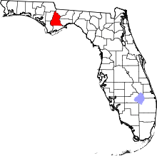 | |
| CDPs | ||
| Unincorporated communities |
| |