Bridgeport Harbor
| Bridgeport Harbor | |
|---|---|
| Location | |
| Country | United States |
| Location | Bridgeport, Connecticut |
| Coordinates | 41°09′24″N 73°10′48″W / 41.15667°N 73.18000°WCoordinates: 41°09′24″N 73°10′48″W / 41.15667°N 73.18000°W |
| Details | |
| Type of harbor | recreational and commercial |
Bridgeport Harbor is an inlet on the north side of Long Island Sound in the state of Connecticut in the United States. The harbor area is an inlet carved by the retreat of the glaciers during the last ice age approximately 13,000 years ago. It is due east of the smaller Black Rock Harbor which is also in the city of Bridgeport.
Geography
The Pequonnock River empties into the inlet on its north end while the Tongue Point Light is at the western end of the mouth of the harbor.
Notable structures in or near the harbor
- Arena at Harbor Yard, a 10,000 seat capacity basketball, hockey and sporting venue.
- The Ballpark at Harbor Yard, a 5,300 seat outdoor venue which is home to the Bridgeport Bluefish baseball team.
- Berkshire No. 7, a shipwreck.
- Pequonnock River Railroad Bridge is listed on the National Register of Historic Places.
- Pleasure Beach, also known as "Steeplechase Island" is a former amusement park and is currently a ghost town. It is the site of the transmission towers for WICC (AM).
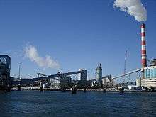
- The PSEG Bridgeport Harbor Generating Station is a familiar piece of the Bridgeport skyline.[1][2]
History
The harbor was dredged by the Army Corps of Engineers in 1964. Current plans to dredge it again have met with opposition from residents of New Haven due to plans to dump the dredged material at Morris Cove.[3]
Transportation
The Bridgeport & Port Jefferson Ferry is located in the harbor. The harbor is located at the end of 8/25 connector, where it merges into Interstate 95, near the Bridgeport (Metro-North station), a stop for Amtrak, Metro-North and Shoreline East trains.
See also
References
- ↑ http://www.stamfordadvocate.com/default/photo/PSEG-s-Bridgeport-Harbor-Generating-Station-in-149663.php
- ↑ "-:: PSEG - we make things work for you ::- The Bridgeport Harbor Generating Station". Retrieved 2010-11-21.
- ↑ http://www.ctpost.com/news/article/New-Haven-residents-angered-by-Bridgeport-Harbor-441765.php