Breton Island (Louisiana)
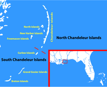

Breton Island is an island (or group of islands) in the Gulf of Mexico near the mouth of the Mississippi River and part of Plaquemines Parish, Louisiana.[1] It is part of the Breton National Wildlife Refuge, which was established in 1904.
Number of islands
In the early 19th century, Breton Island comprised two islands.[2] Prior to Hurricane Opal in 1995, it was a single island, and was divided in two by that storm. After Hurricane Georges in 1998 it was divided into three islands.[3] Hurricane Ivan in 2004 caused additional damage to the island.[3]
Erosion and restoration
Breton Island decreased from 820 acres (330 ha) in 1869 to 125 acres (51 ha) in 1996.[4] Some restoration was done in 1999 funded pursuant to the Water Resources Development Act of 1992;[5] the project was put on hold in 2000.[4] It is possible that fines from the Deepwater Horizon oil spill may be used for rebuilding Breton Island.[6]
References
- ↑ Sir Humphry Davy; U.S. Coast and Geodetic Survey (1896). The collected works of Sir Humphry Davy ...: Discourses delivered before the Royal society. Elements of agricultural chemistry, pt. I. Smith, Elder and Company. pp. 440–. Retrieved 10 December 2012.
- ↑ Richard Brookes (1827). Darby's Universal gazetteer, or A new geographical dictionary:: containing a description of the empires, kingdoms, states, provinces, cities, towns, forts, seas, harbours, rivers, lakes, mountains, capes, &c. in the known world : with the government, customs, and manners, of the inhabitants : the extent, boundaries, and natural productions of each country; and the trade, manufactures, and curiosities of the cities and towns : Illustrated by a neat coloured map of the United States. Bennett & Walton, 37, Market Street. pp. 101–. Retrieved 10 December 2012.
- 1 2 "USGS National Wetlands Research Center: Prehurricane Survey of Barrier Islands Post Hurricane Ivan". National Wetlands Research Center. U.S. Department of the Interior. September 18, 2004. Retrieved 2012-12-10.
- 1 2 "Consistency Issues & Projects - Department of Natural Resources, State of Louisiana". Retrieved 10 December 2012.
- ↑ Creef, Edward D.; Mathies, Linda G.; Hennington, Susan M. (2003). "Dredging '02": 1–5. doi:10.1061/40680(2003)13. ISBN 978-0-7844-0680-9.
|chapter=ignored (help) - ↑ "Louisiana lining up major restoration projects to build with BP oil spill fine money". New Orleans Times-Picaune. November 29, 2012. Retrieved 2012-12-11.
Coordinates: 29°27′51″N 89°11′58″W / 29.46417°N 89.19944°W