Brethour, Ontario
| Brethour | |
|---|---|
| Township (single-tier) | |
| Township of Brethour | |
 | |
 Brethour | |
| Coordinates: 47°40′N 79°34′W / 47.667°N 79.567°W | |
| Country |
|
| Province |
|
| District | Timiskaming |
| Government | |
| • Type | Township |
| • Federal riding | Nipissing—Timiskaming |
| • Prov. riding | Timiskaming—Cochrane |
| Area[1] | |
| • Land | 82.05 km2 (31.68 sq mi) |
| Population (2011)[1] | |
| • Total | 129 |
| • Density | 1.6/km2 (4/sq mi) |
| Time zone | EST (UTC-5) |
| • Summer (DST) | EDT (UTC-4) |
| Area code(s) | 705 |
Brethour is a township in the Canadian province of Ontario, located within the Timiskaming District.
The township had a population of 129 in the Canada 2011 Census.
Demographics
Population trend:[2]
- Population in 2011: 129 (2006 to 2011 population change: 10.3%)
- Population in 2006: 117
- Population in 2001: 157
- Population in 1996: 181
- Population in 1991: 179
Private dwellings occupied by usual residents: 46 (total dwellings: 54)
Mother tongue:[3]
- English as first language: 91.3%
- French as first language: 8.7%
- English and French as first language: 0%
- Other as first language: 0%
History
Brethour Township was surveyed in 1887. It was then later officially incorporated on October 17, 1917. The township's title was derived from the name of a prominent business man from Brantford, Ontario: H.W. Brethour.
Located in the District of Temiskaming, Brethour sits on the Ontario/Quebec provincial border. The first people to settle in the area were Edmond and Philomene Robert. Other mentionable early-settler family names include Schmidt, Cooke, Armstrong, Doonan, Broderick, and Goddard; many of which have living descendants still residing within the community. Most notably, Mr. Leonard Broderick continues to own and reside at the farm in which his great-grandfather William Broderick settled in 1903. Although the Brodericks are the only family to have remained on the same original land, many other original settler families have living descendants that have taken up residence on other lots within the township
See also
References
- 1 2 2011 Census Profile
- ↑ Statistics Canada: 1996, 2001, 2006, 2011 census
- ↑ "2006 Community Profile".
 |
Unorganized West Timiskaming | | ||
| Hilliard | |
| ||
| ||||
| | ||||
| Harley | Casey |
| City | 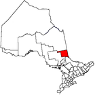 | |
|---|---|---|
| Towns | ||
| Townships | ||
| Village | ||
| Indian Reserves | ||
| Unorganized areas | ||
| Local services boards | ||
| ||
Coordinates: 47°40′N 79°34′W / 47.667°N 79.567°W