Brateyevo District
| Brateyevo District район Братеево (Russian) | |
|---|---|
 Location of Brateyevo District in Moscow | |
| Coordinates: 55°38′02″N 37°45′49″E / 55.63389°N 37.76361°ECoordinates: 55°38′02″N 37°45′49″E / 55.63389°N 37.76361°E | |
 Apartment blocks in Brateyevo District | |
.png) |
.png) |
|
| |
| Location | |
| Country | Russia |
| Federal subject | Moscow |
| Statistics | |
| Area | 7.63 km2 (2.95 sq mi)[1] |
| Population (2010 Census) | 102,600 inhabitants[2] |
| • Urban | 100% |
| • Rural | 0% |
| Density | 13,446.92/km2 (34,827.4/sq mi)[3] |
| Time zone | MSK (UTC+03:00)[4] |
| Official website | |
| Brateyevo District on WikiCommons | |
Brateyevo District (Russian: райо́н Брате́ево) is a district of Southern Administrative Okrug of the federal city of Moscow, Russia, located in the southeast of Moscow on the right bank of the Moskva River. Population: 102,600 (2010 Census);[2] 94,644 (2002 Census).[5] The area of the district is 7.63 square kilometers (2.95 sq mi).[1]
History
Several pagan mounds dated back to ancient settlements have been discovered on the territory of Brateyevo District. The settlement transformed into the prosperous village located on the Brateyevo hill which later gave its name to the district. In 1960 Brateyevo village became administrative part of Moscow. In the 1980s Brateyevo village has been demolished during the construction of the modern district.
Transportation
Metro
- Borisovo, opened on December 2, 2011; located in western part of district
- Alma-Atinskaya, opened on December 24, 2012; located in eastern part of district
Nearest stations, which are not located in Brateyevo District but accessible using public transportation:
References
- 1 2 Показатели муниципальных образования. Братеево (in Russian). Территориальный орган Федеральной службы государственной статистики по г. Москве. Retrieved August 10, 2011.
- 1 2 Russian Federal State Statistics Service (2011). "Всероссийская перепись населения 2010 года. Том 1" [2010 All-Russian Population Census, vol. 1]. Всероссийская перепись населения 2010 года (2010 All-Russia Population Census) (in Russian). Federal State Statistics Service. Retrieved June 29, 2012.
- ↑ The value of density was calculated automatically by dividing the 2010 Census population by the area specified in the infobox. Please note that this value is only approximate as the area specified in the infobox does not necessarily correspond to the area of the entity proper or is reported for the same year as the population.
- ↑ Правительство Российской Федерации. Федеральный закон №107-ФЗ от 3 июня 2011 г. «Об исчислении времени», в ред. Федерального закона №271-ФЗ от 03 июля 2016 г. «О внесении изменений в Федеральный закон "Об исчислении времени"». Вступил в силу по истечении шестидесяти дней после дня официального опубликования (6 августа 2011 г.). Опубликован: "Российская газета", №120, 6 июня 2011 г. (Government of the Russian Federation. Federal Law #107-FZ of June 31, 2011 On Calculating Time, as amended by the Federal Law #271-FZ of July 03, 2016 On Amending Federal Law "On Calculating Time". Effective as of after sixty days following the day of the official publication.).
- ↑ Russian Federal State Statistics Service (May 21, 2004). "Численность населения России, субъектов Российской Федерации в составе федеральных округов, районов, городских поселений, сельских населённых пунктов – районных центров и сельских населённых пунктов с населением 3 тысячи и более человек" [Population of Russia, Its Federal Districts, Federal Subjects, Districts, Urban Localities, Rural Localities—Administrative Centers, and Rural Localities with Population of Over 3,000] (XLS). Всероссийская перепись населения 2002 года [All-Russia Population Census of 2002] (in Russian). Retrieved August 9, 2014.
External links
- Official website of Brateyevo District (Russian)
- Official website of Brateyevo Municipal Formation (Russian)
| Central Administrative Okrug | 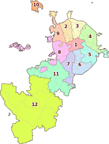 . . | |
|---|---|---|
| Northern Administrative Okrug | ||
| North-Eastern Administrative Okrug | ||
| Eastern Administrative Okrug | ||
| South-Eastern Administrative Okrug | ||
| Southern Administrative Okrug | ||
| South-Western Administrative Okrug | ||
| Western Administrative Okrug | ||
| North-Western Administrative Okrug | ||
| Zelenogradsky Administrative Okrug | ||
| Novomoskovsky Administrative Okrug |
| |
| Troitsky Administrative Okrug |
| |