Bras d'Or Lake
| Bras d'Or Lake | |
|---|---|
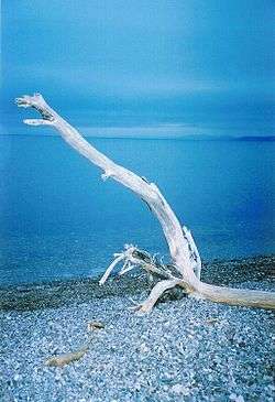 in late summer | |
| Location | Cape Breton Island, Nova Scotia |
| Coordinates | 45°51′37″N 60°46′44″W / 45.86028°N 60.77889°WCoordinates: 45°51′37″N 60°46′44″W / 45.86028°N 60.77889°W |
| Primary outflows |
Gulf of St. Lawrence Atlantic Ocean |
| Basin countries | Canada |
| Max. length | 100 kilometres (62 mi) |
| Max. width | 50 kilometres (31 mi) |
| Surface area | 1,099 km2 (424 sq mi) |
| Max. depth | 287 m (942 ft) |
| Water volume | 32,000,000,000 m3 (4.2×10¹⁰ cu yd)[1] |
| Shore length1 | 1,000 kilometres (621 mi) (excluding islands)[1] |
| Surface elevation | 0 metres (0 ft) (sea level) |
| 1 Shore length is not a well-defined measure. | |

Bras d'Or Lake /brəˈdɔːr/ is an inland sea, or large body of partially fresh/salt water in the centre of Cape Breton Island in the province of Nova Scotia, Canada.[2] Bras d'Or Lake is sometimes referred to as the Bras d'Or Lakes or the Bras d'Or Lakes system; however, its official geographic name is Bras d'Or Lake[3] as it is a singular entity. Canadian author and yachtsman Silver Donald Cameron describes Bras d'Or Lake as "A basin ringed by indigo hills laced with marble. Islands within a sea inside an island." The lake is connected to the North Atlantic by natural channels, the Great Bras d'Or Channel north of Boularderie Island and the Little Bras d'Or Channel to south of Boularderie Island, connect the northeastern arm of the lake to the Cabot Strait. The Bras d'Or is also connected to Atlantic Ocean via the Strait of Canso by means of a lock canal completed in 1869—the St. Peters Canal, at the southern tip of the lake.
There are several competing explanations of the origin of the name "Bras d'Or". The most popular is that the first Europeans to discover and subsequently settle the area were French, naming the lake Bras d'Or meaning "arm of gold"; this likely referring to the sun's rays reflected upon its waters. However, on the maps of 1872 and earlier, the lake is named "Le Lac de Labrador," (or more simply "Labrador")[4][5] and this is more likely the true derivation of the present name. The literal meaning of Labrador is "Laborer."[6][7] In a paper prepared by the late Dr. Patterson for the Nova Scotia Historical Society he says he believed the name Bras d'Or came from the Breton form of Bras 'd'eau arm of water or of the sea.[6][7]
The Mi'kmaq Nation named it Pitu'pok, roughly translated as "long salt water".
With an area of approximately 1,099 square kilometres,[8] the extents of Bras d'Or Lake measures roughly 100 km in length and 50 km in width. Surrounded almost entirely by high hills and low mountains, the shape of the lake is dominated by the Washabuck Peninsula in the centre-west, Boularderie Island in the northeast, and a large peninsula extending from the centre-east dominated by the Boisdale Hills. The Washabuck Peninsula and Boisdale Hills divide the lake into northern and southern basins, linked by the 1 km wide Barra Strait. The maximum depth of Bras d'Or Lake of 287 metres is found in the St. Andrews Channel.
This area was designated the Bras d'Or Lake Biosphere Reserve by UNESCO in 2011.[9]
Subdivisions
The effect of local topography has resulted in the following major components of Bras d'Or Lake:
Northern Basin
- Great Bras d'Or
- Little Bras d'Or
- St. Andrews Channel
- St. Patricks Channel
- Baddeck Bay
- Nyanza Bay
- Whycocomagh Bay
Southern Basin
- Denys Basin
- St. Peters Inlet
- East Bay
- West Bay
The largest part of the lake measures approximately 25 kilometres across in the southern basin, framed by East Bay and West Bay with Denys Basin to the north and St. Peters Inlet to the south. The Barra Strait is crossed by highway and railway bridges running between the Washabuck Peninsula and the Boisdale Hills.
Rivers
The following major rivers empty into the lake (which can also be defined as an inland sea, or a gulf):
- River Denys
- Middle River
- Baddeck River
- Skye River
- Georges River
- Washabuck River
The restricted tidal exchange in its three points of contact with the Atlantic ocean, coupled with significant freshwater drainage from the many rivers and streams in the lake watershed, cause the lake water to have less salinity than the surrounding ocean. Although salinity varies throughout the lake system, it approximates a one third fresh, two-thirds sea water mixture, and hence may be termed brackish water. Without much exchange with the ocean outside the island, the lake water quality is threatened by runoff from human activities in the surrounding watershed, especially from sewage treatment plants and septic tanks, ocean-going ships and small craft plying the lake system. Partly for this reason, the lakes were designated a UNESCO Biosphere Reserve.
Wildlife
Bras d'Or Lake is home to an array of wildlife with successful lobster and oyster fisheries, as well as the pursuit of other marine species. The lake's largely undeveloped shorelines have resulted in significant concentrations of bald eagle populations.
Boating
A renowned summer vacation destination, the area around the Bras d'Or Lake has become popular with recreational boaters. As the majority of cruising vessels enter the lake from the south via Lennox Passage and the St. Peters Canal, St. Peter's Lion's Club Marina located in Strachan's Cove (about 900 metres west of the Canal) in St. Peter's, Nova Scotia is the generally the first port of call for boats entering the lake. St. Peters Marina is one of the largest marinas in the Bras d'Or and has full boating services. Baddeck is home to two marinas, two full service boatyards and the Bras d'Or Yacht Club. Ben Eoin, in the East Bay, has a 75-slip marina with full services which opened in May 2013. The community operated Barra Strait Marina in Grand Narrows reopened in 2012.
Sailing Yacht Racing is a long traditions in the Bras d'Or, with the various yacht clubs around lake hosting annual Regattas and race weeks. Regatta Week hosted by the Bras d'Or Yacht Club has been an annual tradition for over 100 years.[10] A new addition to the summer racing calendar is the annual Race the Cape, now in its fourth year, a point-to-point sail race of 175 nautical miles, broken into five legs of up to 40 nautical miles through the Bras d’Or Lake and along Cape Breton Island’s Atlantic coast leading north to the Cape Breton Highlands. Race the Cape is an International Sailing Federation – Off Shore Special Regulations (OSR) Category 4 Race, for both cruising boats and racing yachts. There are both Spinnaker and Non-Spinnaker Divisions.[11]
While there are more than 20 launch ramps for trailered boats spread throughout the lake, they are scarce outside the lake villages.
The heavily indented shoreline of the lake system, bold shores and numerous protected coves and harbours with snug anchorages provide shelter and keep wave action small, resulting in the lake being known as one of the best sailing waters in North America.
Ocean-going ships presently enter the lake at the Great Bras d'Or and via the St. Patricks Channel to a gypsum quarry at Little Narrows.
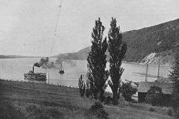
Before construction of the Trans-Canada Highway and other roadways, ships and boats plied the Bras d'Or Lake carrying coal, gypsum, marble, agricultural and forestry products from Cape Breton to the outside world, via barge through the St. Peters Canal to destinations along the Atlantic coast of North America. In addition, some products - like marble quarried into the early 20th century at Marble Mountain, were shipped by lake barges through both lakes to Sydney for transshipment. Mail boats also ran on scheduled service across the lakes until the 1960s, providing connecting passenger service to the train at Iona.
Lakeside development
The largest communities located on Bras d'Or Lake are the villages of Baddeck, Eskasoni, Little Bras d'Or, St. Peter's, and Whycocomagh. Remaining parts of lake shorelines are largely rural with some farming, although encroaching urban sprawl from Sydney in the Cape Breton Regional Municipality (CBRM) is approaching East Bay. Many cottage and recreational properties are located in rural areas, largely owned by people from Sydney, Halifax, or from out of province.
There is little significant protection for shorelines from development in the form of designated parks or conservation areas. In addition, Nova Scotia does not provide much protection of rural areas from subdivision of property. Despite this, most of the shoreline is undeveloped.
Until modern roads were built in the 20th century, coastal freighters/steamships would make the rounds to various lakeside communities, frequently making connection with passenger trains at Iona/Grand Narrows where the railway crossed the Barra Strait.
Unlike the industrial part of CBRM where coal, steel, and manufacturing industries flourished in the early 20th century, and the petroleum, manufacturing, and pulp and paper industries located in the Strait of Canso region since the construction of the Canso Causeway in 1955, Bras d'Or Lake has no major industries within its watershed aside from logging and gypsum extraction.
Mi'kmaq culture
The Mi'kmaq called the Bras d'Or "Pitupaq" Ba-doo-buck (long salt water). The lake connected ancient lakeside and even ocean coastal communities elsewhere on Cape Breton Island by Canoe such as Chapel Island, Eskasoni, Wagmatcook, Waycobah, and Galtoneg, among many others. The lake was also a major source of food for these historic communities, with abundant populations of mussels, crabs, clams, trout, salmon, herring, cod and mackerel.
Historic role as a research center and first Bell Labs
From the summer of 1886, famed inventor and scientist Alexander Graham Bell made his estate and future retirement home at Red Head, a peninsula opposite Baddeck. He named his 640 Acre estate Beinn Bhreagh (pronounced "ben vreeah" meaning "Beautiful Mountain" in Scottish Gaelic) and lived there half of his life until his death in 1922. It is because of Bell's connection to this area that Beinn Bhreagh and Baddeck are routinely featured on National Geographic maps showing eastern North America.[12]
Bell established a research laboratory—the first Bell Labs on Beinn Bhreagh, and used the Bras d'Or Lake to test man-carrying kites, airplanes and hydrofoil boats, as part of his many and varying research activities.
Flight of the Silver Dart
Baddeck Bay, between Baddeck and Beinn Bhreagh, was the site of the first officially recognized heavier-than-air powered flight in the British Empire which then included Canada.[12] The flight was performed by an airplane designed by Dr. Alexander Graham Bell, F.C. Baldwin and Glenn Curtiss and others, in the original Bell Labs on Beinn Bhreagh. The Silver Dart flew off the frozen ice of Baddeck Bay in January 1909. Commemorating this event, 100 years later, in January, 2009 a replica of the original airplane was flown off the ice in the same location: Baddeck Bay.
After demonstrating their airplanes using tricycle landing wheels and other innovations, Bell's laboratory on Beinn Bhreagh designed and built a hydrofoil boat- the HD4 - which set a water speed record of 71 MPH (63 knots) in 1919. HMCS Bras d'Or, an experimental 1960s-era Canadian Forces hydrofoil, reportedly the world's fastest warship ever built, was named honor of the hydrofoils tested long before on Baddeck Bay by Bell.
In 2003, National Geographic Traveler rated Cape Breton Island its second-ranked worldwide destination for sustainable tourism, citing Bras d'Or Lake as having a major influence on this designation. Cape Breton Island tied for second place with New Zealand's South Island and Chile's Torres del Paine, behind the Norwegian fjords.
"The Bras d'Or Lakes are my favorite landscape on planet Earth. Nestled into the rolling hills of Cape Breton, Nova Scotia, their pristine tidal waters reflect centuries of Scottish culture, music, and friendly people."
Gilbert M. Grosvenor, Chairman of the Board, National Geographic Society
Via Rail Canada's weekly Halifax–Sydney tourist passenger train, the Bras d'Or was named in honour of the spectacular scenery provided by Bras d'Or Lake along the eastern part of its journey.
See also
References
- 1 2 "Canadian Technical Report of Hydrography and Ocean Sciences 230 - Modelling the tides of the Bras d'Or Lakes" (PDF). Department of Fisheries and Oceans - 2003.
- ↑
 Chisholm, Hugh, ed. (1911). "Bras d'Or". Encyclopædia Britannica (11th ed.). Cambridge University Press.
 - ↑ "Bras d'Or Lake". Natural Resources Canada.
- ↑ "Carte du Canada ou de la Nouvelle France et des decouvertes que y ont ete faites. Dressee sur plusieurs observations et sur un grand nombre de relations imprimees ou manuscrites. Par Guillaume Del'Isle, Geographe de l'Academie Royale des Sciences. A Paris - David Rumsey Historical Map Collection (includes map)". Guillaume DeLisle, Quai de l'Horloge a l'Aigle d'Or, Paris, 1708. Retrieved April 24, 2012.
- ↑ "A Chart Of The Gulf Of St. Laurence, Composed From A Great Number Of Actual Surveys - David Rumsey Historical Map Collection (includes map)". Sayer and Bennett, London, 1708. Retrieved April 24, 2012.
- 1 2 "Bras d'Or Lake". Sayer and Bennett, London, 1708. Government of Nova Scotia. Retrieved April 24, 2012.
- 1 2 "Bras d'Or Lake (C. B.)". Place-names of the province of Nova Scotia by Thomas J. Brown. Royal Print & Litho. in Halifax, N.S. 1922.
- ↑ "Facts About Canada: Lakes". The Atlas of Canada. Natural Resources Canada.
- ↑ "UNESCO Biosphere". UNESCO.
- ↑ "Archived copy" (PDF). Archived from the original (PDF) on 2016-03-04. Retrieved 2015-11-22.
- ↑ "Race the Cape, the Race". Race the Cape Association.
- 1 2 Bethune, Jocelyn. Historic Baddeck: Images of our past, Nimbus Publishing, Halifax, N.S., 2009, ISBN 1-55109-706-0, ISBN 978-1-55109-706-0.
External links
- Great Canadian Lakes: Bras d'Or Lake. Archived.
- The Natural History of Nova Scotia, 916 Bras d'Or Lake. Archived.
- Bras d’Or Preservation Nature Trust
- Cruising Cape Breton — The Cruisers' Guide to Cape Breton Island and the Bras d'Or Lakes