Bramhall
| Bramhall | |
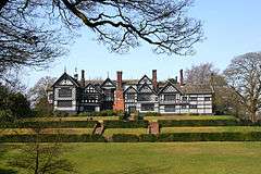 Bramall Hall is a Tudor mansion and local landmark |
|
 Bramhall |
|
| Population | 17,436 (2011) |
|---|---|
| OS grid reference | SJ890845 |
| Metropolitan borough | Stockport |
| Metropolitan county | Greater Manchester |
| Region | North West |
| Country | England |
| Sovereign state | United Kingdom |
| Post town | STOCKPORT |
| Postcode district | SK7 |
| Dialling code | 0161 |
| Police | Greater Manchester |
| Fire | Greater Manchester |
| Ambulance | North West |
| EU Parliament | North West England |
| UK Parliament | Cheadle |
|
|
Coordinates: 53°21′25″N 2°09′50″W / 53.357°N 2.164°W
Bramhall is a suburb of the Metropolitan Borough of Stockport, in Greater Manchester, England. Historically part of Cheshire, it has a population of about 25,500,[1] being measured at 17,436 at the 2011 Census.[2]
Bramhall is an affluent area and has been rated the "least lonely" place in Britain.[3][4][5]
History
The manor of Bramall dates from the Anglo-Saxon period, when it was held as two separate estates by two Saxon freemen, Brun and Hacun.[6] In 1070, William the Conqueror subdued the north-west of England, and divided the land among his followers. The manor of "Bramale" was given to Hamon de Massey, who eventually became the first Baron of Dunham Massey.[7] The earliest reference to Bramall was recorded in the Domesday Book as "Bramale", a name derived from the Old English words brom meaning broom, both indigenous to the area, and halh meaning nook or secret place, probably by water. De Masci received the manor as wasteland, since it had been devastated by William the Conqueror's subdual. By the time of the Domesday survey, the land was recovering and cultivated again.[8]
In 1875 Bramhall was one of eight civil parishes of Cheshire to be included in the Stockport Rural rural sanitary district. The sanitary district became the Stockport Rural District in 1894. The parish was abolished in 1900 and its former area became part of the Hazel Grove and Bramhall civil parish and urban district. In 1974 the district was abolished, under the Local Government Act 1972, and its former area was transferred to Greater Manchester to be combined with that of other districts to form the Metropolitan Borough of Stockport.[9]
Governance
Bramhall is part of the parliamentary constituency of Cheadle. Mary Robinson, Conservative, has been the local MP since 2015.
Landmarks

Bramall Hall, situated in 28 hectares (0.28 km2) of parkland, is an example of a 14th-century Cheshire building. In 2016 an extensive program of restoration work was completed by a dedicated team. The Ladybrook flows through the park towards Cheadle and Bramall Hall.
The war memorial commemorates the deaths of 89 men killed in the two world wars.[10]
Churches

The Church of England parish church of St Michael and All Angels[11] in Robins Lane was consecrated in 1911 when Bramhall parish was created, although the building was not completed until 1963. It replaced an earlier mission church opened in 1890.[12]
Other churches in Bramhall include the Methodist church near the centre of the village, the United Reformed church located on Bramhall Lane South, the Baptist church located on Woodford Road, the Catholic Church of St Vincent de Paul in Handley Road and Ford's Lane Evangelical church.
Recreation
There is a recreation centre linked with the High School. Bramhall's most notable sporting club is Bramhall Cricket Club, close to the Cheshire border to the south of the village. There are also three lawn tennis clubs (LTC), Bramhall Queensgate LTC, to the north, Bramhall Lane LTC, close to the village, and Bramhall Park LTC, close to the park.
Transport
Bramhall railway station is on the main line from Manchester to London via Macclesfield and Stoke-on-Trent. Local stopping trains stop every hour during week days on their way to/from Manchester Piccadilly and Stoke-on-Trent. Buses link Bramhall to Manchester (X57), Stockport (378), Cheadle Hulme (X57,307/8), Woodford (X57), Parrs Wood (X57) and Hazel Grove (307/8).
 |
Cheadle | Stockport | Great Moor | |
| Cheadle Hulme | |
Hazel Grove | ||
| ||||
| | ||||
| Handforth | Woodford | Poynton |
Amenities
Bramhall has a number of bars, restaurants, cafes, clothes shops, hairdressers, beauty salons, charity shops, churches and a library. Many of these are housed in Bramhall's village square,[13] although some shops are in and around the main roads. There is also a recreation centre, a high school and several primary schools. There are two golf courses in Bramhall: Bramhall and Bramall Park Golf Clubs. There are also three tennis centres: Bramhall Lane, Bramhall Park and Bramhall Queensgate.
Housing
The sixties and early seventies saw a rapid growth in housing stock with the construction of four main housing estates: The Parkside and the New House Farm estates are in the north of Bramhall, The Dairyground estate is in central Bramhall and The "Little Australia" estate is in the south of Bramhall. Bramhall also has a small pocket of ex-council housing near to the village centre on the Australia estate.
Dairyground
The Dairyground estate in Central Bramhall is the largest of the four estates. Dairyground is bordered by the Ladybrook river to the North, the Bramhall golf club to the East, the West Coast Main Line to the South and the A5102 (Bramhall Lane South) to the West.[14] The estate consists of more than Twenty five roads and Dairyground Road is the centre of the estate, it has a range of shops such as a co-operative, some flats and a care home. The estate is served by Stagecoach Manchester[15] and is in close proximity to Bramhall railway station. Bramhall High School is situated on the estate. The Dairyground estate is part of the Bramhall North Ward.[16]
Little Australia
The Little Australia estate (so called as all the roads are name after towns in Australia) is bordered by the West Coast Main Line to the north, the Bramhall oil terminal to the east, Bramhall town centre to the west and Moorend Golf Club to the south. The largest road on the estate is Meadway, which starts in Bramhall town centre and runs through the heart of the estate for its entire length. Meadway has a number of shops, care homes and two large car parking facilities which are served by multiple CCTV cameras. There is also a recycling centre situated on the Meadway east car park. Housing on the estate is composed of ex-council terraces, bungalows, flats, semi-detached and detached properties. Lumb Lane park is located on the estate and consists of two football pitches, a small children's playground and a caged football/basketball court. Bramhall village hall is located on Lumb Lane. Greater Manchester Police once trialed a section 30 dispersal order on the estate and Bramhall town centre to combat anti-social behaviour, particularly in the Lumb Lane/Meadway areas. Queensgate primary school is located on Albany road. The Australia estate is part of the Bramhall South Ward.
New House Farm Estate
The New House Farm Estate is to the north of Bramhall and extends into Hazel Grove after crossing the Fred Perry Way. It is home to a Co-operative and a pub, the Shady Oak. The main roads through the estate are Grange Road, which links to Bramhall Lane South, and the Ringmore Road. The estate is served by the 374 bus route between Hazel Grove Station and Reddish. The estate has a mixture of detached, semi-detached houses and flats. The New House Farm contains a section of the Fred Perry Way joining the estate from Bridge Lane and exiting up into Woodsmoor. The estate is part of the Bramhall North Ward.
Education
There are several primary schools, including Ladybrook Primary School, Nevill Road, Pownall Green, Queensgate and Moss Hey. Bramhall High School is the local secondary school.
Notable people from Bramhall
- Peter Butterworth – Actor
- Dame Wendy Hiller – Actress born in Bramhall
- Sacha Dhawan – Actor born in Bramhall
- Martin Fry – Lead Singer of ABC
- Mark Hadfield – Actor born in Bramhall
- Peter Fendall - Auditor
See also
External links
Bramhall United Reformed Church
References
- ↑ Bramhall South and Bramhall North Wards."Ward mid-year population estimates for England and Wales (experimental)". Office for National Statistics. Mid-2007 Quinary Estimates for 2009 wards (experimental).
- ↑ "Village population 2011". Retrieved 8 January 2016.
- ↑ Williams, Jennifer (3 December 2008). "Happy to be home in Bramhall". Stockport Express. M.E.N. Media.
- ↑ "Bramhall named friendliest spot". Manchester Evening News. 19 April 2010. Retrieved 11 March 2014.
- ↑ Stockport council (2005),"Bramhall Area Public Health Report".
- ↑ [http://www.bramhill.net/BramhillInfo/brammanor.html Bramhill info]], Retrieved 26 January 2015
- ↑ "Bramhall Park (2005)". Stockport Metropolitan Borough Council. Retrieved 11 March 2014.
- ↑ Dean, p14
- ↑ http://www.manchesteronline.co.uk/ewm/maps/districtstext.html
- ↑ "The Men of the Bramhall War Memorial" (PDF). Archived from the original (PDF) on 13 November 2013. Retrieved 13 November 2013.
- ↑ "Bramhall Parish Church - St Michaels".
- ↑ "BRAMHALL, ST MICHAEL AND ALL ANGELS". The National Archives. Retrieved 13 November 2013.
- ↑ http://www.bramhallcentre.co.uk/
- ↑ http://maps.google.co.uk/maps?hl=en-GB&q=dairyground%20estate&sourceid=navclient-ff&rlz=1B3GGGL_en-GBGB314GB314&um=1&ie=UTF-8&sa=N&tab=wl
- ↑ http://www.nationalrail.co.uk/stations/bml/busmaps.html
- ↑ Skinner, Miles (29 November 2006). "Bramhall businesses forced to barricade themselves in". Stockport Express. M.E.N. Media.