Bradfield, South Yorkshire
Coordinates: 53°25′44″N 1°35′53″W / 53.429°N 1.598°W
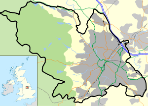
Bradfield is a civil parish in the City of Sheffield, in South Yorkshire, England.
The civil parish is extensive, the western half is situated in the moorlands of the Peak District, the eastern half is in lower agricultural land and contains the parishes significant habitations, which include the Sheffield suburb of Stannington, as well as Oughtibridge and Worrall, and the villages of High Bradfield and Low Bradfield. The parish also includes several reservoirs, and a number of minor settlements. Bradfield is located 8 miles (13 km) from Sheffield city centre and 14 miles (23 km) from Barnsley.
On 6 July 2014, Stage 2 of the 2014 Tour de France from York to Sheffield, passed through the village. It was also the location of the seventh climb of the stage, the Category 4 Côte de Bradfield. It was 1 kilometre (0.62 mi) long at an average gradient of 7.4%. The one point in the King of the Mountains competition was claimed by Andriy Hrivko of Astana Pro Team.[1]
Description
Bradfield is one of the largest parishes in England,[2] and covers extensive moor and agricultural land around the Damflask Reservoir, Dale Dike Reservoir, Strines Reservoir, and Agden Reservoirs, including the Bradfield, Midhope, and Broomhead moors and eastern parts of the Howden moors. The western end of the parish reaches to the upper parts of the Upper Derwent Valley with part of its boundary forming Yorkshire’s border with Derbyshire. The northern part of the parish includes the Langsett reservoir and Midhope reservoir, and borders the town and civil parish of Stocksbridge.[3][4]
The eastern edge reaches the western extent of the urban spread of Sheffield, and includes the suburb of Stannington, as well as the villages of Oughtibridge, Wharncliffe Side, and Worrall. Minor habitations within the parish include Midhopestones, Upper Midhope on the northern edge, and Dungworth in the southeastern part.[3][4] The moorland villages of High Bradfield and Low Bradfield are located within the parish. High Bradfield possesses a Gothic revival church, and the earthworks of a motte and bailey castle. Low Bradfield is less historic, having been largely destroyed in the Great Sheffield flood of 1864.
At the time of the 2001 census the parish had a population of 14,915,[5] increasing to 17,100 at the 2011 Census.[6] The parish extends across the City of Sheffield electoral wards of Stocksbridge and Upper Don and Stannington Ward, and covers more than a third of the land area of Sheffield City Council.[3]
References
- ↑ "Tour de France Stage 1". Retrieved 15 July 2014.
- ↑ Midhopestones Conservation Area Appraisal (Final Draft) (PDF), October 2007, 5.8,
..the parish of Bradfield, which has the distinction of being one of Englands largest parishes (14,400 hectares in extent).
- 1 2 3 "Area: Bradfield CP (Parish)", 2001 Census: Key Statistics, Office for National Statistics
- 1 2 Ordnance survey. 1:25000, c.2012
- ↑ "Area: Bradfield CP (Parish) - Parish Headcounts", 2001 Census: Key Statistics, Office for National Statistics
- ↑ "Civil Parish population 2011". Neighbourhood Statistics. Office for National Statistics. Retrieved 11 March 2016.
External links
- Sources for the history of Bradfield Produced by Sheffield City Council's Libraries and Archives
![]() Media related to Bradfield, South Yorkshire at Wikimedia Commons
Media related to Bradfield, South Yorkshire at Wikimedia Commons
| About Sheffield | |||||||
|---|---|---|---|---|---|---|---|
| Electoral wards |
| ||||||
| Suburbs and estates |
| ||||||
| Towns and villages |
| ||||||
| Other areas | |||||||
| |||||||