Boxford, Massachusetts
| Boxford, Massachusetts | ||
|---|---|---|
| Town | ||
|
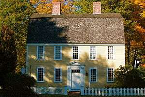
The Holyoke-French House (c. 1760) in East Boxford Village | ||
| ||
 Location in Essex County in Massachusetts | ||
| Coordinates: 42°39′40″N 70°59′50″W / 42.66111°N 70.99722°WCoordinates: 42°39′40″N 70°59′50″W / 42.66111°N 70.99722°W | ||
| Country | United States | |
| State | Massachusetts | |
| County | Essex | |
| Settled | 1645 | |
| Incorporated | 1685 | |
| Government | ||
| • Type | Open town meeting | |
| Area | ||
| • Total | 24.4 sq mi (63.2 km2) | |
| • Land | 23.6 sq mi (61.0 km2) | |
| • Water | 0.8 sq mi (2.2 km2) | |
| Elevation | 95 ft (29 m) | |
| Population (2010) | ||
| • Total | 7,965 | |
| • Density | 330/sq mi (130/km2) | |
| Time zone | Eastern (UTC-5) | |
| • Summer (DST) | Eastern (UTC-4) | |
| ZIP code | 01921 | |
| Area code(s) | 351 / 978 | |
| FIPS code | 25-07420 | |
| GNIS feature ID | 0618294 | |
| Website | Town of Boxford Official Web Site | |

Boxford is a town in Essex County, Massachusetts, United States. According to the U.S. Census Bureau, the town's population in 2010 was 7,965.[1]
The original town center of Boxford, was East Boxford and other areas in the eastern part of the town, comprise the census-designated place of Boxford.
History
Boxford was first settled in 1646 as part of Rowley Village by Abraham Redington. When it was officially incorporated in 1685, about forty families resided in Boxford. Farming was the primary occupation of the early settlers although craftsmen were also found among the townspeople. The largest industry in Boxford was the match factory (located on Lawrence Road) which operated from 1866 to 1905. The original building of the First Church was built in 1701 in East Boxford Village. As the population of West Boxford expanded, the legislature designated this section as precinct 2 in 1735. Town meetings alternated between East and West parishes. The first West Boxford church building was erected in 1774.
Geography
According to the United States Census Bureau, the town has a total area of 24.4 square miles (63.2 km2), of which 23.6 square miles (61.0 km2) is land and 0.85 square miles (2.2 km2), or 3.46%, is water.[2]
Boxford is divided into Boxford Village (commonly called East Boxford) and West Boxford Village, corresponding to the respective East and West Boxford centers. It is heavily forested and criss-crossed by various streams and brooks, many of which empty into the Ipswich River on Boxford's southern border. A number of ponds dot town as well, among them Stiles Pond, Cedar Pond, Spofford Pond, Lowe Pond, Four Mile Pond and Baldpate Pond. Throughout Boxford there are also a number of scenic hiking trails. The highest natural point in Boxford is Bald Hill, at an elevation of 243 feet (74 m). It sits in a corner of the Boxford State Forest, near Interstate 95 and the town's border with Middleton.
Small farms are interspersed throughout Boxford. Stone walls, remnants of old farming land boundaries, meander through the area. One major farm located in Boxford is Small Oxx farm, a branch of the main farm, Smolak's, located in North Andover.
Boxford is located near the geographic center of Essex County, with Boxford Center about 10 miles (16 km) southeast of Lawrence and 24 miles (39 km) north of Boston. The town is bordered by Haverhill to the north, Groveland to the northeast, Georgetown and Rowley to the east, Ipswich and Topsfield to the southeast, Middleton to the southwest, and North Andover to the west.
The eastern end of Boxford is crossed by Interstate 95, with three exits lying within the town. Route 133 crosses through the northern part of town, from North Andover to Georgetown, and Route 97 crosses through the eastern part of town, from Topsfield to Georgetown. The town does not have any means of mass transportation. The Newburyport/Rockport Line of the MBTA Commuter Rail passes through neighboring Rowley and Ipswich to the east, and the Haverhill/Reading Line passes to the north. The nearest small airport is Lawrence Municipal Airport, located in North Andover, and the nearest domestic and international air service is Logan International Airport.
Demographics
| Historical population | ||
|---|---|---|
| Year | Pop. | ±% |
| 1850 | 982 | — |
| 1860 | 1,020 | +3.9% |
| 1870 | 847 | −17.0% |
| 1880 | 824 | −2.7% |
| 1890 | 865 | +5.0% |
| 1900 | 704 | −18.6% |
| 1910 | 718 | +2.0% |
| 1920 | 588 | −18.1% |
| 1930 | 652 | +10.9% |
| 1940 | 778 | +19.3% |
| 1950 | 926 | +19.0% |
| 1960 | 2,010 | +117.1% |
| 1970 | 4,032 | +100.6% |
| 1980 | 5,374 | +33.3% |
| 1990 | 6,266 | +16.6% |
| 2000 | 7,921 | +26.4% |
| 2010 | 7,965 | +0.6% |
| * = population estimate. Source: United States Census records and Population Estimates Program data.[3][4][5][6][7][8][9][10][11][12] | ||
As of the census of 2000, there were 7,921 people, 2,568 households, and 2,254 families residing in the town. The population density was 330.4 people per square mile (127.6/km²). There were 2,610 housing units at an average density of 42.0 persons/km² (108.9 persons/sq mi). The racial makeup of the town was 97.37% White, 0.34% African American, 0.11% Native American, 1.21% Asian, 0.03% Pacific Islander, 0.29% from other races, and 0.64% from two or more races. 0.85% of the population were Hispanic or Latino of any race.
There were 2,568 households out of which 48.5% had children under the age of 18 living with them, 80.0% were married couples living together, 6.0% had a female householder with no husband present, and 12.2% were non-families. 9.7% of all households were made up of individuals and 4.9% had someone living alone who was 65 years of age or older. The average household size was 3.08 and the average family size was 3.32.
In the town the population was spread out with 32.2% under the age of 18, 4.2% from 18 to 24, 25.8% from 25 to 44, 28.5% from 45 to 64, and 9.3% who were 65 years of age or older. The median age was 39 years. For every 100 females there were 98.9 males. For every 100 females age 18 and over, there were 94.8 males.
The median income for a household in the town was $113,212, and the median income for a family was $119,491. Males had a median income of $90,397 versus $48,042 for females. The per capita income for the town was $48,846. 1.4% of the population and 0.8% of families were below the poverty line. Out of the total people living in poverty, 0.8% are under the age of 18 and 3.1% are 65 or older
Government and infrastructure
Boxford employs the open town meeting form of government, and is led by a board of selectmen and a town executive secretary. Boxford has a police department, a fire department with two branches in the main villages, two post offices, a public works department and a library, which is located within the town hall. A second library was located in West Boxford, but due to budget constraints it was closed in 2008. The nearest hospitals are Merrimack Valley Hospital in Haverhill to the north, Lawrence General to the west, and Beverly Hospital to the south.
On the state level, Boxford is under the jurisdiction of the Central District Court of Essex County, located in Haverhill. It is patrolled by the Newbury station of Troop A of the Massachusetts State Police. The town is represented by two representatives, from the Fourth and Eighteenth Essex districts, in the Massachusetts House of Representatives, and as part of the First Essex and Middlesex district in the Massachusetts Senate. On the national level, the town is part of Massachusetts's 6th congressional district, and has been represented by John F. Tierney (D) since 1997. The state's senior Senator, elected in the 2012, is Elizabeth Warren (D), and its junior Senator, elected in 2013, is Ed Markey.
Politics
One of the few communities in Massachusetts to have more registered Republicans than Democrats,[13] the town is more conservative than the rest of the state. In 2012, Mitt Romney received 59% of the vote in Boxford compared to President Obama's 40%.[14]
Education
Boxford has one high school, Masconomet Regional High School, named after Chief Masconomet, sagamore of the Agawam tribe, who lived in Essex County at the time of English colonization. Masconomet is a regional school, serving the towns of Boxford, Middleton, and Topsfield. The school is commonly believed to be in Topsfield because it has a Topsfield street address. However, the school, which is located on Endicott Road, lies entirely within Boxford. Students may also elect to attend North Shore Technical High School in Middleton or Essex Agricultural and Technical High School in Danvers. Nearby private schools include The Governor's Academy in Rowley; St. John's Preparatory School (boys only) in Danvers; Phillips Academy in Andover; and Brooks School in North Andover.
Masconomet Regional Middle School is also located in Boxford, and is attached to the high school. There are also three elementary schools in Boxford. The Harry Lee Cole School, which serves Preschool through Grade 2, is located near East Boxford center. The Spofford Pond School, serving Grades 3 through 6, is located on the western side of the town's geographic center. Boxford Academy, Preschool - 5th grade, is located in First Church Congregational Boxford on Georgetown Road.
Boxford also has two public schools, Spofford Pond School and Harry Lee Cole School.
Points of interest
Boxford State Forest, near Interstate 95 and the towns of Topsfield and Middleton, boasts numerous walking trails that weave through heavily forested areas.
Commercial landmarks in and around town include Benson's Ice Cream, Paisley's Farm Stand and West Village Provisions in West Boxford center, Ingaldsby Farm, the Boxford Community store in East Boxford (also known as "Jack's" or "Wayne's", after its former and current owners), and the Boxford House of Pizza, which lies near the border of Boxford and Georgetown.
"Witch Hollow Farm", (a.k.a. the Tyler-Wood House) build c. 1727 by Capt. John Tyler the son of Moses Tyler whose sister-in-law, Rebecca Eames was tried in the famous 1693 Salem Witch Trials, found at the intersection of Main Street and Ipswich Road in Boxford. The house gets its name from a hollow that was on the Tyler property in the 1690s where Rebecca Eames claimed, in her trial, that she was bewitched by the Devil.[15] It is a nationally recognized "Haunted House".
The town has a retirement community called Four Mile Village which sits adjacent to Four Mile Pond. The waiting list to get into this community is significant, and prospective applicants must either be former Boxford residents, or primary family members of current Boxford residents.
Boxford's centrally located Stiles Pond is the site for the town beach, where membership can be purchased by Boxford residents only, each season for a nominal fee through the Boxford Athletic Association (BAA). The adjacent ballpark and play area were recently designated by unanimous vote at Town Meeting as "Keith Koster Memorial Baseball Park" in memory of one of Boxford's beloved young people, a former Boxford beach lifeguard and baseball player, victim of a senseless act of crime in 2006.
Baldpate Pond, and the adjacent state recreation area, is another popular swimming, fishing, boating, and hiking location.
Camp Rotary is a popular summer co-ed boarding camp located on Stiles Pond off Ipswich Road in Boxford. Danvers YMCA holds another popular summer day camp on Stiles Pond, next to the town beach.
Notable people
- Mark Bavaro (1963-), former Pro Bowl football player for the New York Giants
- Raymond Bourque (1960-), Boston Bruins - Hall of Fame - former team captain
- Johnny Bucyk (1935-), Boston Bruins - Hall of Fame - former team captain
- Thomas Knowlton (1740–1776), colonel in the Continental Army during the American Revolution
- Chris Kreider (1990-), Boston College ice hockey player and current member of the New York Rangers
- Earle O. Latham (1908-1999), first vice-president of the Federal Reserve Bank of Boston
- Alice Freeman Palmer (1855–1902), American educator and president of Wellesley College
- Sidney Perley (1858–1928), lawyer, writer, author, poet, historian
- Rufus Porter (1792–1884), painter, designer of the Colt revolver, and founder of Scientific American
- Debra Jo Rupp (1951-), actress, known for her role as Kitty Foreman in That '70s Show
- Henry Knox Sherrill (1890-1980), an Episcopal clergyman and the 20th Presiding Bishop of the Episcopal Church from 1947 to 1958, having previously served as Bishop of Massachusetts (1930-1947)
- Jermaine Wiggins, New England Patriots
- Carl Yastrzemski (1939-), former member of the Boston Red Sox and a Major League Baseball hall of fame
References
- ↑ "Profile of General Population and Housing Characteristics: 2010 Demographic Profile Data (DP-1): Boxford town, Essex County, Massachusetts". U.S. Census Bureau, American Factfinder. Archived from the original on September 11, 2013. Retrieved August 31, 2012.
- ↑ "Geographic Identifiers: 2010 Demographic Profile Data (G001): Boxford town, Essex County, Massachusetts". U.S. Census Bureau, American Factfinder. Archived from the original on September 11, 2013. Retrieved August 31, 2012.
- ↑ "TOTAL POPULATION (P1), 2010 Census Summary File 1". American FactFinder, All County Subdivisions within Massachusetts. United States Census Bureau. 2010.
- ↑ "Massachusetts by Place and County Subdivision - GCT-T1. Population Estimates". United States Census Bureau. Retrieved July 12, 2011.
- ↑ "1990 Census of Population, General Population Characteristics: Massachusetts" (PDF). US Census Bureau. December 1990. Table 76: General Characteristics of Persons, Households, and Families: 1990. 1990 CP-1-23. Retrieved July 12, 2011.
- ↑ "1980 Census of the Population, Number of Inhabitants: Massachusetts" (PDF). US Census Bureau. December 1981. Table 4. Populations of County Subdivisions: 1960 to 1980. PC80-1-A23. Retrieved July 12, 2011.
- ↑ "1950 Census of Population" (PDF). Bureau of the Census. 1952. Section 6, Pages 21-10 and 21-11, Massachusetts Table 6. Population of Counties by Minor Civil Divisions: 1930 to 1950. Retrieved July 12, 2011.
- ↑ "1920 Census of Population" (PDF). Bureau of the Census. Number of Inhabitants, by Counties and Minor Civil Divisions. Pages 21-5 through 21-7. Massachusetts Table 2. Population of Counties by Minor Civil Divisions: 1920, 1910, and 1920. Retrieved July 12, 2011.
- ↑ "1890 Census of the Population" (PDF). Department of the Interior, Census Office. Pages 179 through 182. Massachusetts Table 5. Population of States and Territories by Minor Civil Divisions: 1880 and 1890. Retrieved July 12, 2011.
- ↑ "1870 Census of the Population" (PDF). Department of the Interior, Census Office. 1872. Pages 217 through 220. Table IX. Population of Minor Civil Divisions, &c. Massachusetts. Retrieved July 12, 2011.
- ↑ "1860 Census" (PDF). Department of the Interior, Census Office. 1864. Pages 220 through 226. State of Massachusetts Table No. 3. Populations of Cities, Towns, &c. Retrieved July 12, 2011.
- ↑ "1850 Census" (PDF). Department of the Interior, Census Office. 1854. Pages 338 through 393. Populations of Cities, Towns, &c. Retrieved July 12, 2011.
- ↑
- ↑
- ↑ http://tylertopics.com/genealogy/genealogy.homesteadhistory.html
Sources
- Perley, Sidney. History of Boxford, Essex County, Massachusetts. Full images at books.google.Published 1880.
- Perley, Francis, Samuel Wood, Moses Carleton. 1795 Map of Boxford.
- Dorman, Moses. 1830 Map of Boxford.
- Beers, D.G. 1872 Atlas of Essex County 1872 Map of Boxford. Plate 57.
- Walker, George H. 1884 Atlas of Essex County 1884 Map of Boxford. Plate 109.
- Vital Records of Boxford to 1849. Originally published by the Topsfield Historical Society in 1905. Transcribed and put online by John Slaughter and Jodi Salero 2007.
- Boxford Town Records 1685-1706. Transcribed by Sidney Perley in 1880. From page 41 of Volume 5 of The Historical Collections of the Topsfield Historical Society. Published 1899. Full image and OCR at books.google.
- Burt, Bill (2007-07-02). "'67 Sox were there from start to finish". Gloucester Daily Times. Retrieved 2007-07-11.
- Goode, John (2004-12-14). "A Giant Among Us". Boston.com. Retrieved 2007-02-03.
External links
| Wikimedia Commons has media related to Boxford, Massachusetts. |
Municipalities and communities of Essex County, Massachusetts, United States | ||
|---|---|---|
| Cities | 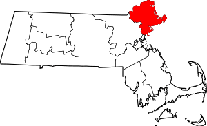 | |
| Towns | ||
| CDPs | ||
| Other villages | ||